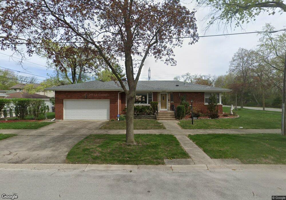
9300 Lotus Ave Skokie, IL 60077
Estimated Value: $416,000 - $467,800
3
Beds
2
Baths
1,425
Sq Ft
$308/Sq Ft
Est. Value
About This Home
This home is located at 9300 Lotus Ave, Skokie, IL 60077 and is currently estimated at $439,200, approximately $308 per square foot. 9300 Lotus Ave is a home located in Cook County with nearby schools including Old Orchard Jr High School, Jane Stenson School, and Niles North High School.
Ownership History
Date
Name
Owned For
Owner Type
Purchase Details
Closed on
May 30, 2002
Sold by
Weissman Carol and Urkov Jodi
Bought by
Hakimiyan Ardeshir R and Hakimiyan Arnavaz A
Current Estimated Value
Home Financials for this Owner
Home Financials are based on the most recent Mortgage that was taken out on this home.
Original Mortgage
$252,900
Outstanding Balance
$107,687
Interest Rate
6.91%
Estimated Equity
$331,513
Purchase Details
Closed on
Mar 15, 1994
Sold by
Nbd Bank
Bought by
Weissman Carol and Bergman Jodi
Create a Home Valuation Report for This Property
The Home Valuation Report is an in-depth analysis detailing your home's value as well as a comparison with similar homes in the area
Home Values in the Area
Average Home Value in this Area
Purchase History
| Date | Buyer | Sale Price | Title Company |
|---|---|---|---|
| Hakimiyan Ardeshir R | $281,000 | -- | |
| Weissman Carol | -- | -- |
Source: Public Records
Mortgage History
| Date | Status | Borrower | Loan Amount |
|---|---|---|---|
| Open | Hakimiyan Ardeshir R | $252,900 |
Source: Public Records
Tax History Compared to Growth
Tax History
| Year | Tax Paid | Tax Assessment Tax Assessment Total Assessment is a certain percentage of the fair market value that is determined by local assessors to be the total taxable value of land and additions on the property. | Land | Improvement |
|---|---|---|---|---|
| 2024 | $7,916 | $32,663 | $8,423 | $24,240 |
| 2023 | $7,679 | $35,000 | $8,423 | $26,577 |
| 2022 | $7,679 | $35,000 | $8,423 | $26,577 |
| 2021 | $6,322 | $26,428 | $5,183 | $21,245 |
| 2020 | $6,321 | $26,428 | $5,183 | $21,245 |
| 2019 | $6,471 | $29,695 | $5,183 | $24,512 |
| 2018 | $5,933 | $25,459 | $4,697 | $20,762 |
| 2017 | $5,992 | $25,459 | $4,697 | $20,762 |
| 2016 | $6,596 | $27,921 | $4,697 | $23,224 |
| 2015 | $6,066 | $24,357 | $4,049 | $20,308 |
| 2014 | $5,940 | $24,357 | $4,049 | $20,308 |
| 2013 | $5,910 | $24,357 | $4,049 | $20,308 |
Source: Public Records
Map
Nearby Homes
- 9234 Central Ave
- 5449 Arcadia St
- 5644 Lyons St
- 9539 Lorel Ave
- 9314 Menard Ave
- 9320 Menard Ave
- 9224 Menard Ave
- 9508 Leamington Ave
- 5459 Suffield Ct
- 5536 Greenwood St
- 5247 Suffield Ct
- 9655 Woods Dr Unit 1304
- 9655 Woods Dr Unit P350
- 8918 Parkside Ave
- 9715 Woods Dr Unit 1104
- 9715 Woods Dr Unit 903
- 9725 Woods Dr Unit 1913
- 9725 Woods Dr Unit 802
- 9725 Woods Dr Unit 309
- 9725 Woods Dr Unit 2015
- 9306 Lotus Ave
- 9310 Lotus Ave
- 9256 Lotus Ave
- 9314 Lotus Ave
- 9301 Linder Ave
- 9307 Linder Ave
- 9311 Linder Ave
- 9318 Lotus Ave
- 9250 Lotus Ave
- 9257 Linder Ave
- 9315 Linder Ave
- 9253 Linder Ave
- 9322 Lotus Ave
- 9321 Linder Ave
- 9321 Linder Ave
- 9249 Linder Ave
- 9326 Lotus Ave
- 9327 Linder Ave
- 9327 Linder Ave
- 9245 Linder Ave