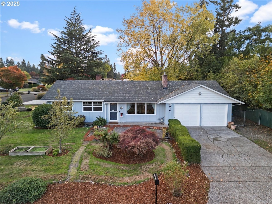
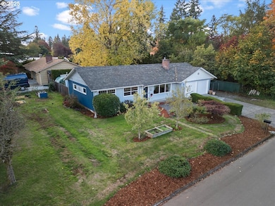
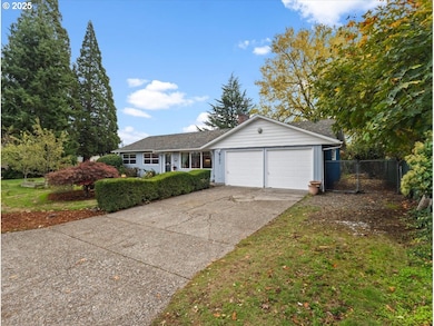
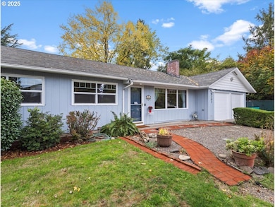
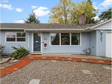
9301 Silver Star Ave Vancouver, WA 98664
Vancouver Heights NeighborhoodEstimated payment $2,925/month
Highlights
- RV Access or Parking
- Engineered Wood Flooring
- Corner Lot
- Solar Power System
- Bonus Room
- Private Yard
About This Home
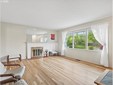
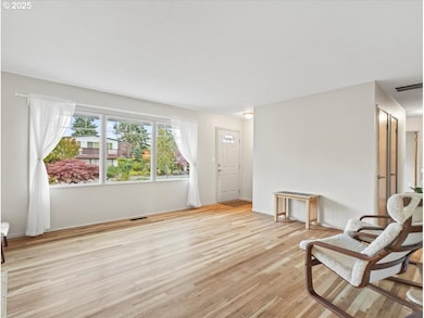
Updated 3 bed/1.5 bath home on a corner lot with 18 solar panels & 2 Tesla Powerwall's—enjoy minimal electric bills! Light-filled 1,265 SF interior with refinished white oak hardwood floors, wood-burning fireplace, newer windows, gas furnace, A/C & water heater. Outdoor living shines with custom brick patio, raised garden beds, berries, grapes & pear trees. RV parking w/50-amp plug, sewer connect + 2nd RV area. Near Peace Health Hospital, freeways, shopping & dining.
Listing Agent
Cascade Hasson Sotheby's International Realty License #7063 Listed on: 10/30/2025

Home Details
Home Type
- Single Family
Est. Annual Taxes
- $3,539
Year Built
- Built in 1955 | Remodeled
Lot Details
- 7,840 Sq Ft Lot
- Fenced
- Corner Lot
- Level Lot
- Landscaped with Trees
- Private Yard
- Garden
- Raised Garden Beds
Parking
- 2 Car Attached Garage
- Extra Deep Garage
- Garage Door Opener
- Driveway
- On-Street Parking
- RV Access or Parking
Home Design
- Composition Roof
- Wood Siding
- Metal Siding
Interior Spaces
- 1,265 Sq Ft Home
- 1-Story Property
- Wood Burning Fireplace
- Double Pane Windows
- Vinyl Clad Windows
- Family Room
- Living Room
- Dining Room
- Bonus Room
- Engineered Wood Flooring
- Crawl Space
- Laundry Room
Kitchen
- Free-Standing Gas Range
- Range Hood
- Plumbed For Ice Maker
- Dishwasher
- Stainless Steel Appliances
Bedrooms and Bathrooms
- 3 Bedrooms
Eco-Friendly Details
- Solar Power System
Outdoor Features
- Patio
- Shed
- Outbuilding
Schools
- Marshall Elementary School
- Mcloughlin Middle School
- Fort Vancouver High School
Utilities
- Forced Air Heating and Cooling System
- Heating System Uses Gas
- Electric Water Heater
Community Details
- No Home Owners Association
Listing and Financial Details
- Assessor Parcel Number 037915839
Map
Home Values in the Area
Average Home Value in this Area
Tax History
| Year | Tax Paid | Tax Assessment Tax Assessment Total Assessment is a certain percentage of the fair market value that is determined by local assessors to be the total taxable value of land and additions on the property. | Land | Improvement |
|---|---|---|---|---|
| 2025 | $3,539 | $379,524 | $184,450 | $195,074 |
| 2024 | $3,544 | $362,193 | $184,450 | $177,743 |
| 2023 | $3,550 | $378,660 | $190,650 | $188,010 |
| 2022 | $3,090 | $380,778 | $190,650 | $190,128 |
| 2021 | $2,851 | $308,732 | $155,000 | $153,732 |
| 2020 | $2,593 | $268,539 | $123,228 | $145,311 |
| 2019 | $2,338 | $253,057 | $102,690 | $150,367 |
| 2018 | $2,490 | $236,347 | $0 | $0 |
| 2017 | $2,207 | $208,959 | $0 | $0 |
| 2016 | $2,015 | $193,330 | $0 | $0 |
| 2015 | $1,970 | $168,635 | $0 | $0 |
| 2014 | -- | $155,846 | $0 | $0 |
| 2013 | -- | $136,135 | $0 | $0 |
Property History
| Date | Event | Price | List to Sale | Price per Sq Ft |
|---|---|---|---|---|
| 10/30/2025 10/30/25 | For Sale | $499,000 | -- | $394 / Sq Ft |
Purchase History
| Date | Type | Sale Price | Title Company |
|---|---|---|---|
| Interfamily Deed Transfer | -- | None Available | |
| Interfamily Deed Transfer | -- | -- | |
| Warranty Deed | $72,500 | Chicago Title Insurance Co |
Mortgage History
| Date | Status | Loan Amount | Loan Type |
|---|---|---|---|
| Previous Owner | $65,250 | No Value Available |
Source: Regional Multiple Listing Service (RMLS)
MLS Number: 294613038
APN: 037915-839
Disclaimer: Certain information contained herein is derived from information provided by parties other than Homes.com. All information provided is deemed reliable, but is not guaranteed to be accurate and should be independently verified.
![]() The content relating to real estate for sale on this web site comes in part from the IDX program of the RMLS™ of Portland, Oregon. Real estate listings held by brokerage firms other than Ten-X are marked with the RMLS™ logo, and detailed information about these properties includes the names of the listing brokers. Listing content is copyright © 2025 RMLS™, Portland, Oregon. Some properties which appear for sale on this web site may subsequently have sold or may no longer be available. All information provided is deemed reliable but is not guaranteed and should be independently verified.
The content relating to real estate for sale on this web site comes in part from the IDX program of the RMLS™ of Portland, Oregon. Real estate listings held by brokerage firms other than Ten-X are marked with the RMLS™ logo, and detailed information about these properties includes the names of the listing brokers. Listing content is copyright © 2025 RMLS™, Portland, Oregon. Some properties which appear for sale on this web site may subsequently have sold or may no longer be available. All information provided is deemed reliable but is not guaranteed and should be independently verified.
- 509 Mt Shasta Dr
- 409 SE 95th Ave
- 9301 E Mill Plain Blvd
- 8607 Mount Thielson Ave
- 8601 Saint Helens Ave
- 715 SE Sherley Ct
- 410 SE 100th Ave
- 214 SE 101st Ave
- 1040 SE Columbia Ridge Dr Unit 2
- 515 SE 102nd Ave
- 220 N Lieser Rd
- 9212 NE 7th St
- 8318 SE Middle Way
- 10305 St Helens Ave
- 300 Baltimore Way
- 8014 SE Middle Way
- 10303 SE 13th Cir
- 1511 SE 86th Ct
- 1323 SE Columbia Crest Ct
- 10216 SE 15th St
- 411 SE Ellsworth Rd
- 1319 SE Ellsworth Rd
- 1221 SE Ellsworth Rd
- 7806 NE 12th St
- 11301 SE 10th St
- 11304 SE 10th St
- 501 NE 112th Ave
- 11301 NE 7th St
- 711 NE 112th Ave
- 604 SE 121st Ave
- 2220 NE Bridgecreek Ave
- 2231 NE Bridgecreek Ave
- 501 SE 123rd Ave
- 1900 NE 113th Ave
- 7401 NE 18th St
- 7531 NE 18th St
- 11202 NE 20th St
- 2201 NE 112th Ave
- 12800 SE 7th St
- 2400 NE 112th Ave