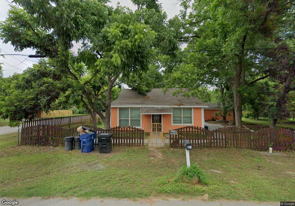
931 Baker St Denison, TX 75020
Estimated Value: $205,000
--
Bed
--
Bath
1,242
Sq Ft
$165/Sq Ft
Est. Value
About This Home
This home is located at 931 Baker St, Denison, TX 75020 and is currently estimated at $205,000, approximately $165 per square foot. 931 Baker St is a home located in Grayson County with nearby schools including Scott Middle School, Denison High School, and St. Luke's Parish Day School.
Ownership History
Date
Name
Owned For
Owner Type
Purchase Details
Closed on
May 25, 2025
Sold by
Baltasar Colin
Bought by
Colin Francisco and Garduno Monica
Current Estimated Value
Purchase Details
Closed on
Aug 16, 2012
Sold by
Rodriguez Oscar and Rodriguez Rosalinda
Bought by
Colin Baltasar and Tavera Cecilia
Purchase Details
Closed on
Jan 9, 2009
Sold by
Clarka Toby G and Bledsoe Janita E
Bought by
Rodriguez Oscar and Rodriguez Rosalinda
Purchase Details
Closed on
Oct 16, 2008
Sold by
Douglas Aven
Bought by
Bledsoe Janita E and Clark Toby G
Purchase Details
Closed on
May 24, 2007
Sold by
Holt Norman and Holt Joyce
Bought by
Douglas Aven
Create a Home Valuation Report for This Property
The Home Valuation Report is an in-depth analysis detailing your home's value as well as a comparison with similar homes in the area
Home Values in the Area
Average Home Value in this Area
Purchase History
| Date | Buyer | Sale Price | Title Company |
|---|---|---|---|
| Colin Francisco | -- | None Listed On Document | |
| Colin Baltasar | -- | None Available | |
| Rodriguez Oscar | -- | None Available | |
| Ali Ahmad | -- | North American Title Co | |
| Bledsoe Janita E | -- | None Available | |
| Douglas Aven | $10,000 | None Available |
Source: Public Records
Tax History Compared to Growth
Tax History
| Year | Tax Paid | Tax Assessment Tax Assessment Total Assessment is a certain percentage of the fair market value that is determined by local assessors to be the total taxable value of land and additions on the property. | Land | Improvement |
|---|---|---|---|---|
| 2025 | $4,121 | $178,413 | $57,466 | $120,947 |
| 2024 | $4,121 | $177,368 | $54,973 | $122,395 |
| 2023 | $3,821 | $168,653 | $53,267 | $115,386 |
| 2022 | $3,811 | $160,412 | $53,267 | $107,145 |
| 2021 | $2,755 | $109,251 | $23,747 | $85,504 |
| 2020 | $2,846 | $107,891 | $19,680 | $88,211 |
| 2019 | $3,000 | $109,021 | $19,680 | $89,341 |
| 2018 | $2,819 | $101,621 | $10,496 | $91,125 |
| 2017 | $2,528 | $90,371 | $5,773 | $84,598 |
| 2016 | $2,236 | $79,935 | $5,773 | $74,162 |
| 2015 | $1,683 | $59,561 | $5,773 | $53,788 |
| 2014 | $1,445 | $51,147 | $5,773 | $45,374 |
Source: Public Records
Map
Nearby Homes
- 919 W Collins St
- 923 W Collins St
- 921 W Collins St
- 916 W Collins St
- 923 Dubois St
- 930 W Florence St
- 603 W Star St
- 904 W Florence St
- 1901 Woodlawn Blvd
- 1044 W Ford St
- 701 W Star St
- 711 Dubois St
- 928 W Chase St
- 938 Amsden St
- 616 & 618 Rice St
- 700 Dubois St
- 614 Rice St
- 905 Seymore Cir
- 611 W Baker St
- 614 W Collins St