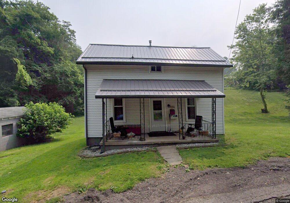
931 N Chestnut St Barnesville, OH 43713
Estimated Value: $102,534 - $129,000
2
Beds
2
Baths
952
Sq Ft
$122/Sq Ft
Est. Value
About This Home
This home is located at 931 N Chestnut St, Barnesville, OH 43713 and is currently estimated at $116,384, approximately $122 per square foot. 931 N Chestnut St is a home located in Belmont County with nearby schools including Barnesville Elementary School, Barnesville Middle School, and Barnesville High School.
Ownership History
Date
Name
Owned For
Owner Type
Purchase Details
Closed on
Jul 27, 2016
Sold by
Barker Russell R and Barker Dawn R
Bought by
Barker Megan D
Current Estimated Value
Purchase Details
Closed on
Oct 10, 2014
Sold by
Doan Richard
Bought by
Barker Russell R and Barker Dawn R
Purchase Details
Closed on
Aug 2, 2004
Sold by
Hickenbottom Everett R
Bought by
Hickenbottom Everett R
Purchase Details
Closed on
Jan 1, 1986
Sold by
Hickenbottom Everett R
Bought by
Hickenbottom Everett R
Create a Home Valuation Report for This Property
The Home Valuation Report is an in-depth analysis detailing your home's value as well as a comparison with similar homes in the area
Home Values in the Area
Average Home Value in this Area
Purchase History
| Date | Buyer | Sale Price | Title Company |
|---|---|---|---|
| Barker Megan D | -- | Attorney | |
| Barker Russell R | $41,500 | Attorney | |
| Hickenbottom Everett R | -- | -- | |
| Hickenbottom Everett R | -- | -- |
Source: Public Records
Tax History
| Year | Tax Paid | Tax Assessment Tax Assessment Total Assessment is a certain percentage of the fair market value that is determined by local assessors to be the total taxable value of land and additions on the property. | Land | Improvement |
|---|---|---|---|---|
| 2025 | $924 | $28,090 | $4,710 | $23,380 |
| 2023 | $721 | $21,320 | $4,000 | $17,320 |
| 2022 | $721 | $21,322 | $4,000 | $17,322 |
| 2021 | $723 | $21,332 | $4,004 | $17,328 |
| 2020 | $666 | $18,770 | $3,340 | $15,430 |
| 2019 | $668 | $18,770 | $3,340 | $15,430 |
| 2018 | $669 | $18,770 | $3,340 | $15,430 |
| 2017 | $612 | $16,880 | $3,700 | $13,180 |
| 2016 | $589 | $16,880 | $3,700 | $13,180 |
| 2015 | $587 | $16,880 | $3,700 | $13,180 |
| 2014 | $573 | $16,280 | $3,360 | $12,920 |
| 2013 | $571 | $16,280 | $3,360 | $12,920 |
Source: Public Records
Map
Nearby Homes
- 617 Park St
- 618 Park St
- 202 Walton Ave
- 62239 Hillcrest Rd
- 136 E Walnut St
- 152 E Main St
- TBD W Main St
- 613 E Main St
- 0 County Road 114
- 105 Bethesda St
- 61900 Fairview Rd
- 329 S Chestnut St
- 118 Pine Ln
- 164 Pine Ln
- 0 Fairmont Ave Unit 5163774
- 0 Fairmont Ave Unit 5163784
- Lot 1 Cattle Dr
- 0 Nevada Rd
- 57128 Somerton Hwy
- 471 Fair Ave
- 214 Pleasant St
- 214 Pleasant St
- 923 N Chestnut St
- 113 Kennard Ave
- 0 Kennard Ave Unit 3733939
- 0 Kennard Ave Unit 3814502
- 0 Kennard Ave Unit 3889961
- 913 N Chestnut St
- 1028 N Chestnut St
- 118 Kennard Ave
- 213 Pleasant St
- 909 N Chestnut St
- 122 Kennard Ave
- 301 Pleasant St
- 201 Woodland Ave
- 901 N Chestnut St
- 902 N Chestnut St
- 125 North St
- 202 Woodland Ave
- 203 Woodland Ave
Your Personal Tour Guide
Ask me questions while you tour the home.