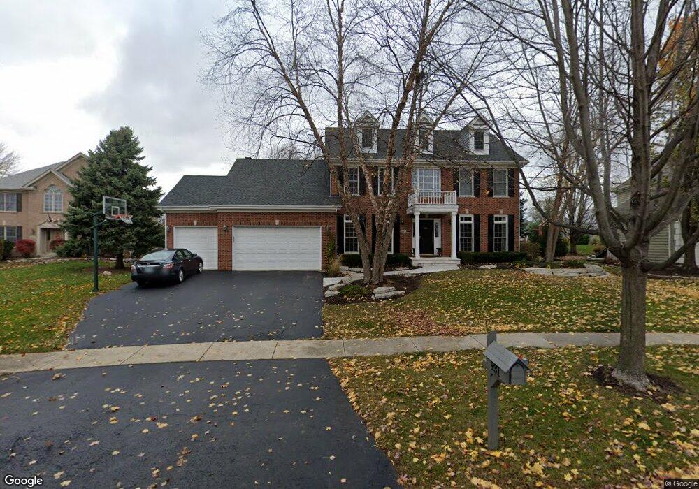
931 Saint Andrews Cir Geneva, IL 60134
Eagle Brook NeighborhoodEstimated Value: $742,000 - $776,000
5
Beds
3
Baths
2,946
Sq Ft
$258/Sq Ft
Est. Value
About This Home
This home is located at 931 Saint Andrews Cir, Geneva, IL 60134 and is currently estimated at $758,945, approximately $257 per square foot. 931 Saint Andrews Cir is a home located in Kane County with nearby schools including Western Avenue Elementary School, Geneva Community High School, and St. Peter School.
Ownership History
Date
Name
Owned For
Owner Type
Purchase Details
Closed on
Jul 19, 2006
Sold by
Primacy Closing Corp
Bought by
Jass Jeffrey and Jass Kerri
Current Estimated Value
Home Financials for this Owner
Home Financials are based on the most recent Mortgage that was taken out on this home.
Original Mortgage
$274,000
Outstanding Balance
$164,456
Interest Rate
6.85%
Mortgage Type
Purchase Money Mortgage
Estimated Equity
$594,489
Purchase Details
Closed on
Jun 8, 2006
Sold by
Rocks Robert K and Rocks Patricia T
Bought by
Primacy Closing Corp
Home Financials for this Owner
Home Financials are based on the most recent Mortgage that was taken out on this home.
Original Mortgage
$274,000
Outstanding Balance
$164,456
Interest Rate
6.85%
Mortgage Type
Purchase Money Mortgage
Estimated Equity
$594,489
Purchase Details
Closed on
Mar 29, 2002
Sold by
Gustafson David C and Yoch Karen
Bought by
Rocks Robert K and Rocks Patricia T
Home Financials for this Owner
Home Financials are based on the most recent Mortgage that was taken out on this home.
Original Mortgage
$326,000
Interest Rate
6.93%
Purchase Details
Closed on
Sep 10, 1997
Sold by
Gustafson Joanne
Bought by
Gustafson C Donald and The Joanne Gustafson Qualified Personal
Home Financials for this Owner
Home Financials are based on the most recent Mortgage that was taken out on this home.
Original Mortgage
$200,000
Interest Rate
7.68%
Purchase Details
Closed on
Jul 31, 1997
Sold by
Batson Lance D and Batson Synthia A
Bought by
Gustafson C Donald and Gustafson Joanne
Home Financials for this Owner
Home Financials are based on the most recent Mortgage that was taken out on this home.
Original Mortgage
$200,000
Interest Rate
7.68%
Purchase Details
Closed on
Feb 3, 1997
Sold by
Keim Corp
Bought by
Batson Lance D and Batson Synthia A
Home Financials for this Owner
Home Financials are based on the most recent Mortgage that was taken out on this home.
Original Mortgage
$250,000
Interest Rate
6.62%
Purchase Details
Closed on
Mar 20, 1996
Sold by
American National Bk&Tr Co Of Chicago
Bought by
Keim Corp
Create a Home Valuation Report for This Property
The Home Valuation Report is an in-depth analysis detailing your home's value as well as a comparison with similar homes in the area
Home Values in the Area
Average Home Value in this Area
Purchase History
| Date | Buyer | Sale Price | Title Company |
|---|---|---|---|
| Jass Jeffrey | $530,000 | First American Title | |
| Primacy Closing Corp | $530,000 | First American Title | |
| Rocks Robert K | $407,500 | Chicago Title Insurance Co | |
| Gustafson C Donald | -- | -- | |
| Gustafson Joanne | -- | -- | |
| Gustafson C Donald | $238,000 | -- | |
| Batson Lance D | $350,000 | Chicago Title Insurance Co | |
| Keim Corp | $86,500 | Chicago Title Insurance Co |
Source: Public Records
Mortgage History
| Date | Status | Borrower | Loan Amount |
|---|---|---|---|
| Open | Jass Jeffrey | $274,000 | |
| Previous Owner | Rocks Robert K | $326,000 | |
| Previous Owner | Gustafson C Donald | $200,000 | |
| Previous Owner | Batson Lance D | $250,000 |
Source: Public Records
Tax History Compared to Growth
Tax History
| Year | Tax Paid | Tax Assessment Tax Assessment Total Assessment is a certain percentage of the fair market value that is determined by local assessors to be the total taxable value of land and additions on the property. | Land | Improvement |
|---|---|---|---|---|
| 2024 | $15,084 | $203,881 | $69,659 | $134,222 |
| 2023 | $14,640 | $185,346 | $63,326 | $122,020 |
| 2022 | $13,969 | $172,222 | $58,842 | $113,380 |
| 2021 | $13,569 | $165,821 | $56,655 | $109,166 |
| 2020 | $13,417 | $163,290 | $55,790 | $107,500 |
| 2019 | $13,385 | $160,199 | $54,734 | $105,465 |
| 2018 | $13,675 | $163,789 | $54,734 | $109,055 |
| 2017 | $13,528 | $159,421 | $53,274 | $106,147 |
| 2016 | $13,597 | $157,266 | $52,554 | $104,712 |
| 2015 | -- | $149,521 | $49,966 | $99,555 |
| 2014 | -- | $145,220 | $49,966 | $95,254 |
| 2013 | -- | $145,220 | $49,966 | $95,254 |
Source: Public Records
Map
Nearby Homes
- 2147 Fargo Blvd
- 839 S Randall Rd
- 1417 Sherwood Ln
- 1736 Kaneville Rd
- 1580 Turnberry Ct
- 1437 Cooper Ln
- 106 Bridgeport Ln
- 1530 Kaneville Rd
- 51 Burgess Rd
- 2694 Berkshire Dr Unit 8
- 2671 Stone Cir Unit 208
- 301 Country Club Place
- 2927 Caldwell Ln Unit 2
- 2692 Stone Cir Unit 203
- 2769 Stone Cir
- 2749 Stone Cir
- 2771 Stone Cir
- 2753 Stone Cir
- 2767 Stone Cir
- 2747 Stone Cir
- 925 Saint Andrews Cir
- 937 Saint Andrews Cir
- 943 Saint Andrews Cir
- 919 Saint Andrews Cir
- 920 Saint Andrews Cir
- 913 Saint Andrews Cir
- 2086 Fargo Blvd
- 2066 Fargo Blvd
- 949 Saint Andrews Cir
- 940 Saint Andrews Cir
- 2094 Fargo Blvd
- 2052 Fargo Blvd
- 2108 Fargo Blvd
- 904 Saint Andrews Cir
- 907 Saint Andrews Cir
- 2038 Fargo Blvd Unit 3
- 1063 Saint Andrews Cir
- 952 Saint Andrews Cir
- 2126 Fargo Blvd
- 955 Saint Andrews Cir