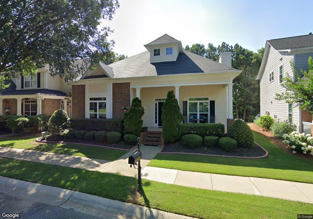
932 Cambron Commons Trace Suwanee, GA 30024
Estimated Value: $409,967 - $500,000
3
Beds
3
Baths
1,897
Sq Ft
$244/Sq Ft
Est. Value
About This Home
This home is located at 932 Cambron Commons Trace, Suwanee, GA 30024 and is currently estimated at $462,242, approximately $243 per square foot. 932 Cambron Commons Trace is a home located in Gwinnett County with nearby schools including Roberts Elementary School, North Gwinnett Middle School, and North Gwinnett High School.
Ownership History
Date
Name
Owned For
Owner Type
Purchase Details
Closed on
Aug 3, 2009
Sold by
Tucker Dorothy J
Bought by
Storey Gary S
Current Estimated Value
Home Financials for this Owner
Home Financials are based on the most recent Mortgage that was taken out on this home.
Original Mortgage
$193,922
Outstanding Balance
$125,725
Interest Rate
5.26%
Mortgage Type
FHA
Estimated Equity
$336,517
Purchase Details
Closed on
Jan 29, 2004
Sold by
Richport Prop Inc
Bought by
Tucker Dorothy Jo
Home Financials for this Owner
Home Financials are based on the most recent Mortgage that was taken out on this home.
Original Mortgage
$109,350
Interest Rate
5%
Mortgage Type
New Conventional
Purchase Details
Closed on
Sep 25, 2003
Sold by
J Squared Inc
Bought by
Richard Properties Inc
Create a Home Valuation Report for This Property
The Home Valuation Report is an in-depth analysis detailing your home's value as well as a comparison with similar homes in the area
Home Values in the Area
Average Home Value in this Area
Purchase History
| Date | Buyer | Sale Price | Title Company |
|---|---|---|---|
| Storey Gary S | $197,500 | -- | |
| Tucker Dorothy Jo | $188,600 | -- | |
| Richard Properties Inc | $210,100 | -- |
Source: Public Records
Mortgage History
| Date | Status | Borrower | Loan Amount |
|---|---|---|---|
| Open | Storey Gary S | $193,922 | |
| Previous Owner | Tucker Dorothy Jo | $109,350 |
Source: Public Records
Tax History
| Year | Tax Paid | Tax Assessment Tax Assessment Total Assessment is a certain percentage of the fair market value that is determined by local assessors to be the total taxable value of land and additions on the property. | Land | Improvement |
|---|---|---|---|---|
| 2025 | $5,411 | $171,240 | $44,080 | $127,160 |
| 2024 | $5,324 | $166,360 | $40,800 | $125,560 |
| 2023 | $5,324 | $143,480 | $35,600 | $107,880 |
| 2022 | $5,223 | $138,640 | $35,600 | $103,040 |
| 2021 | $3,986 | $105,640 | $26,800 | $78,840 |
| 2020 | $3,780 | $99,520 | $23,080 | $76,440 |
| 2019 | $3,280 | $99,520 | $23,080 | $76,440 |
| 2018 | $3,141 | $94,880 | $23,080 | $71,800 |
| 2016 | $2,546 | $77,000 | $24,000 | $53,000 |
| 2015 | $2,318 | $69,160 | $18,400 | $50,760 |
| 2014 | $2,333 | $69,160 | $18,400 | $50,760 |
Source: Public Records
Map
Nearby Homes
- 812 Cambron Commons Trace Unit 2
- 923 Echo Park Dr
- 821 Scales Rd
- 255 Sims Park Place
- 3820 White St
- 765 Green Sapling Trail
- 3655 Belle Fields Crossing
- 3615 Belle Fields Crossing
- 3625 Belle Fields Crossing
- 3675 Belle Fields Crossing
- 3645 Belle Fields Crossing
- 3635 Belle Fields Crossing
- 3685 Belle Fields Crossing
- 714 Urban Grange Way
- 3405 Crop Corner Rd
- 3880 Prairie Field Crossing
- 825 Green Sapling Trail Unit 18
- 704 Urban Grange Way
- 722 Urban Grange Way
- 3761 Lake Point Blvd
- 922 Cambron Commons Trace
- 942 Cambron Commons Trace
- 942 Cambron Commons
- 912 Cambron Commons Trace
- 4110 Baxter Trail
- 902 Cambron Commons Trace Unit 2
- 4120 Baxter Trail
- 913 Cambron Commons Trace Unit 2
- 961 Cambron Commons Trace
- 963 Cambron Commons Trace
- 892 Cambron Commons Trace
- 903 Cambron Commons Trace
- 4130 Baxter Trail
- 965 Cambron Commons Trace
- 967 Cambron Commons Trace
- 893 Cambron Commons Trace Unit 2
- 969 Cambron Commons Trace
- 969 Cambron Commons Trace Unit 3
- 882 Cambron Commons Trace
- 4140 Baxter Trail
Your Personal Tour Guide
Ask me questions while you tour the home.