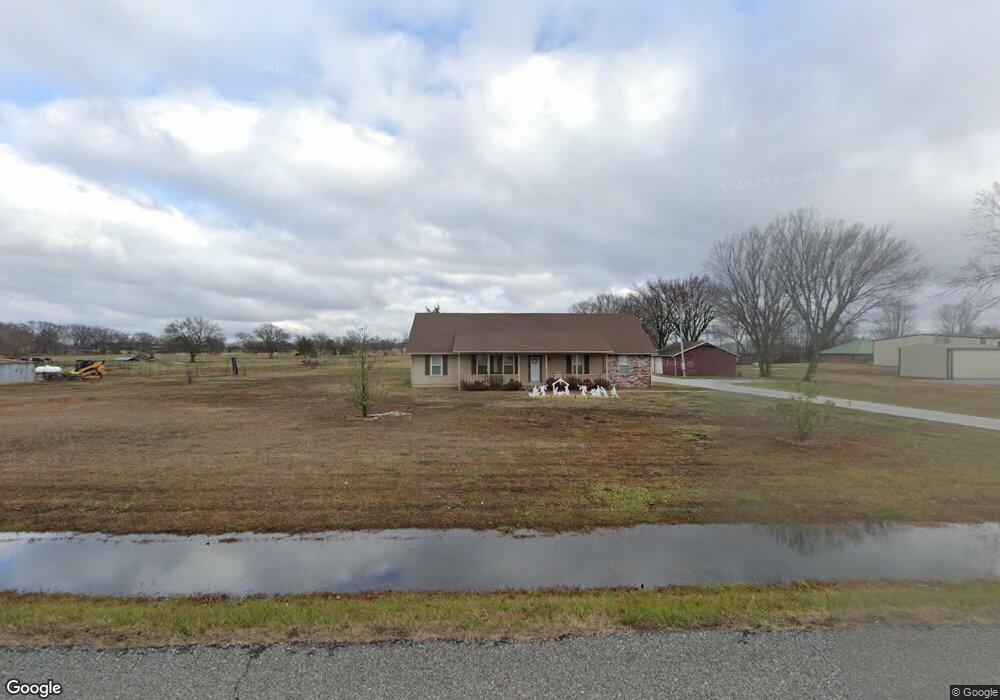
932 N Moseley Rd Colcord, OK 74338
Estimated Value: $223,000 - $397,000
3
Beds
2
Baths
2,000
Sq Ft
$151/Sq Ft
Est. Value
About This Home
This home is located at 932 N Moseley Rd, Colcord, OK 74338 and is currently estimated at $301,448, approximately $150 per square foot. 932 N Moseley Rd is a home located in Delaware County with nearby schools including Moseley Public School.
Ownership History
Date
Name
Owned For
Owner Type
Purchase Details
Closed on
Jul 19, 2006
Sold by
Jones Doug and Jones Douglas Wayne
Bought by
Fredrick Duane and Fredrick Katina
Current Estimated Value
Home Financials for this Owner
Home Financials are based on the most recent Mortgage that was taken out on this home.
Original Mortgage
$105,000
Outstanding Balance
$61,835
Interest Rate
6.6%
Mortgage Type
New Conventional
Estimated Equity
$239,613
Purchase Details
Closed on
Oct 19, 1999
Sold by
Jones Quana Ranae
Purchase Details
Closed on
Jan 26, 1993
Sold by
Butts John William and Butts Evelyn L
Create a Home Valuation Report for This Property
The Home Valuation Report is an in-depth analysis detailing your home's value as well as a comparison with similar homes in the area
Home Values in the Area
Average Home Value in this Area
Purchase History
| Date | Buyer | Sale Price | Title Company |
|---|---|---|---|
| Fredrick Duane | $165,000 | -- | |
| -- | -- | -- | |
| -- | $9,500 | -- |
Source: Public Records
Mortgage History
| Date | Status | Borrower | Loan Amount |
|---|---|---|---|
| Open | Fredrick Duane | $105,000 |
Source: Public Records
Tax History Compared to Growth
Tax History
| Year | Tax Paid | Tax Assessment Tax Assessment Total Assessment is a certain percentage of the fair market value that is determined by local assessors to be the total taxable value of land and additions on the property. | Land | Improvement |
|---|---|---|---|---|
| 2025 | $1,418 | $21,620 | $2,923 | $18,697 |
| 2024 | $1,418 | $21,620 | $2,962 | $18,658 |
| 2023 | $1,418 | $21,620 | $2,377 | $19,243 |
| 2022 | $1,418 | $21,620 | $2,440 | $19,180 |
| 2021 | $1,418 | $21,620 | $2,440 | $19,180 |
| 2020 | $1,418 | $21,620 | $2,440 | $19,180 |
| 2019 | $1,418 | $21,620 | $2,440 | $19,180 |
| 2018 | $1,418 | $21,620 | $2,440 | $19,180 |
| 2017 | $1,563 | $21,620 | $2,440 | $19,180 |
| 2016 | $836 | $12,570 | $2,210 | $10,360 |
| 2015 | $836 | $12,570 | $2,210 | $10,360 |
| 2014 | $836 | $12,570 | $2,210 | $10,360 |
Source: Public Records
Map
Nearby Homes
- 840 N Moseley Rd
- 8302 Covenant Cove
- Tract A Highway 412 (10 Ac Mol)
- TRACT B
- 306 N Moseley Rd
- 20724 E 578 Rd
- 56826 County Road 710
- 5978 Cedar Dr
- 5773 Cedar Dr
- 57128 S 690 Rd
- 369 S Cherry St
- 0 W 412 Hwy Unit 1308057
- 880 Snyder Springs Loop
- 847 Snyder Springs Loop
- 934 Snyder Springs Loop
- 939 Snyder Springs Loop
- 944 Snyder Springs Loop
- 975 Snyder Springs Loop
- 991 Snyder Springs Loop
- 58 Snyder Springs Cir
- 834 N Moseley
- 834 N Moseley
- 994 N Moseley Rd
- 832 N Moseley
- 840 N Moseley Rd Unit TR4
- 840 N Moseley Rd Unit TR3
- 840 N Moseley Rd Unit TR2
- 840 N Moseley Rd Unit TR1
- 0 N Moseley Rd Unit 376884
- 0 N Moseley Rd Unit 376900
- 0 N Moseley Rd Unit 1537867
- 0 N Moseley Rd Unit 713078
- 841 N Moseley Rd
- 764 N Moseley Rd
- 1127 N Moseley Rd
- 688 N Moseley Rd
- 7640 412 Hwy
- 58472 705 S Mosley Rd
- 58472 S 705 Mosley Rd
- 1236 N Moseley Rd