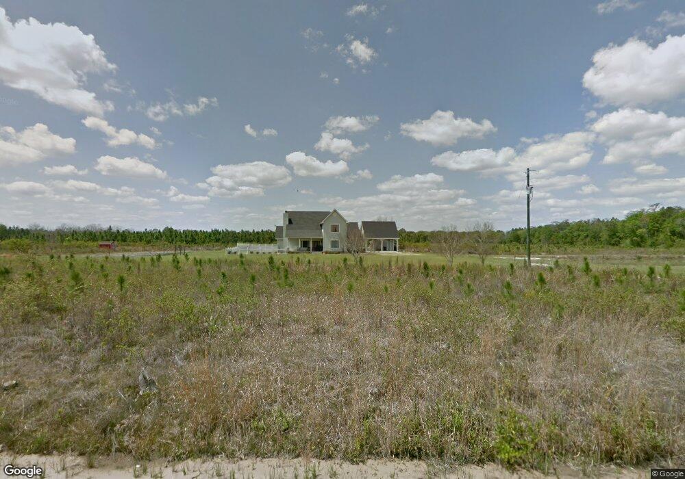
932 Old Racepond Rd Hoboken, GA 31542
Estimated Value: $348,000 - $403,672
4
Beds
4
Baths
2,759
Sq Ft
$139/Sq Ft
Est. Value
About This Home
This home is located at 932 Old Racepond Rd, Hoboken, GA 31542 and is currently estimated at $383,891, approximately $139 per square foot. 932 Old Racepond Rd is a home located in Brantley County with nearby schools including Hoboken Elementary School, Brantley County Middle School, and Brantley County High School.
Ownership History
Date
Name
Owned For
Owner Type
Purchase Details
Closed on
Feb 28, 2020
Sold by
Dowling Ronda Jo Coker
Bought by
Justice Rodney D and Justice Renee M
Current Estimated Value
Home Financials for this Owner
Home Financials are based on the most recent Mortgage that was taken out on this home.
Original Mortgage
$282,000
Outstanding Balance
$249,751
Interest Rate
3.5%
Mortgage Type
VA
Estimated Equity
$134,140
Purchase Details
Closed on
Jun 24, 2010
Sold by
Coker Gary T
Bought by
Coker Ronda
Create a Home Valuation Report for This Property
The Home Valuation Report is an in-depth analysis detailing your home's value as well as a comparison with similar homes in the area
Home Values in the Area
Average Home Value in this Area
Purchase History
| Date | Buyer | Sale Price | Title Company |
|---|---|---|---|
| Justice Rodney D | $282,000 | -- | |
| Coker Ronda | -- | -- |
Source: Public Records
Mortgage History
| Date | Status | Borrower | Loan Amount |
|---|---|---|---|
| Open | Justice Rodney D | $282,000 |
Source: Public Records
Tax History Compared to Growth
Tax History
| Year | Tax Paid | Tax Assessment Tax Assessment Total Assessment is a certain percentage of the fair market value that is determined by local assessors to be the total taxable value of land and additions on the property. | Land | Improvement |
|---|---|---|---|---|
| 2024 | $2,773 | $122,621 | $5,951 | $116,670 |
| 2023 | $322 | $122,080 | $5,410 | $116,670 |
| 2022 | $2,752 | $121,080 | $5,410 | $115,670 |
| 2021 | $2,749 | $79,468 | $5,410 | $74,058 |
| 2020 | $2,758 | $79,079 | $5,021 | $74,058 |
| 2019 | $2,755 | $79,079 | $5,021 | $74,058 |
| 2018 | $2,823 | $83,378 | $9,320 | $74,058 |
| 2017 | $2,823 | $83,378 | $9,320 | $74,058 |
| 2016 | $2,925 | $83,378 | $9,320 | $74,058 |
| 2015 | -- | $83,379 | $9,320 | $74,058 |
Source: Public Records
Map
Nearby Homes
- 4947 High Bluff Rock Rd
- 950 Apple Dr
- 25 Jefferson St
- 20 Marla St
- 220 Chickasaw Rd
- 203 Johnny B St
- 0 Caney Bay Rd
- 12169 Central Ave
- 12091 Central Ave
- 57 Lynn Holly Ln
- 26 Lynn Holly Ln
- 5588 Brunswick Hwy
- 157 Hwy
- 456 Blue Jay Loop
- 00 Blue Jay Ln
- 563 Bennett Rd
- 0-0 Foxwood Rd
- 0 Foxwood Rd
- 56 Fj Melton Ln
- 8.84 Strickland Rd
- 5357 High Bluff Rd
- 5351 High Bluff Rd
- 1076 Old Racepond Rd
- 5341 High Bluff Rd
- 147 Og Lee Rd
- 5296 High Bluff Rd
- 5083 High Bluff Rd
- 5079 High Bluff Rd
- 185 Og Lee Rd
- 16 Og Lee Rd
- 5039 High Bluff Rd
- 4995 High Bluff Rd
- 4947 High Bluff Rd
- 356 Old Racepond Rd
- 91 Stallion Rd
- 116 Stallion Rd
- 106 Leo Loop
- 4975 Mattie Shuman Rd
- 5105 Mattie Shuman Rd
- 0 Mattie Shuman Rd Unit 7387343