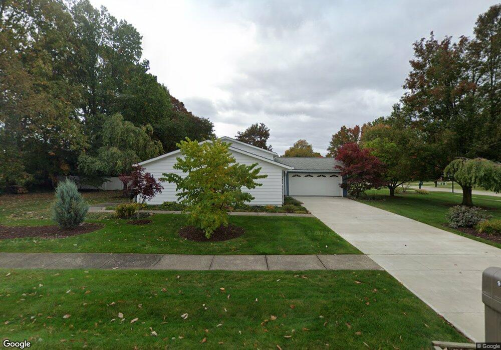
9321 Pheasant Run Place Strongsville, OH 44149
Estimated Value: $320,878 - $368,000
3
Beds
2
Baths
2,060
Sq Ft
$167/Sq Ft
Est. Value
About This Home
This home is located at 9321 Pheasant Run Place, Strongsville, OH 44149 and is currently estimated at $344,970, approximately $167 per square foot. 9321 Pheasant Run Place is a home located in Cuyahoga County with nearby schools including Strongsville High School, Sts Joseph & John Interparochial School, and St Mary School.
Ownership History
Date
Name
Owned For
Owner Type
Purchase Details
Closed on
Aug 5, 2019
Sold by
Papcun Daniel J and Papcun Sherrie M
Bought by
Papcun Daniel J and Papcun Sherrie M
Current Estimated Value
Purchase Details
Closed on
Jun 10, 1977
Sold by
Papcun Daniel J and Papcun Paula J
Bought by
Papcun Daniel J
Purchase Details
Closed on
Jan 1, 1975
Bought by
Papcun Daniel J and Papcun Paula J
Create a Home Valuation Report for This Property
The Home Valuation Report is an in-depth analysis detailing your home's value as well as a comparison with similar homes in the area
Home Values in the Area
Average Home Value in this Area
Purchase History
| Date | Buyer | Sale Price | Title Company |
|---|---|---|---|
| Papcun Daniel J | -- | None Available | |
| Papcun Daniel J | -- | -- | |
| Papcun Daniel J | -- | -- |
Source: Public Records
Tax History Compared to Growth
Tax History
| Year | Tax Paid | Tax Assessment Tax Assessment Total Assessment is a certain percentage of the fair market value that is determined by local assessors to be the total taxable value of land and additions on the property. | Land | Improvement |
|---|---|---|---|---|
| 2024 | $3,900 | $92,855 | $20,265 | $72,590 |
| 2023 | $4,462 | $71,260 | $17,150 | $54,110 |
| 2022 | $4,430 | $71,260 | $17,150 | $54,110 |
| 2021 | $4,395 | $71,260 | $17,150 | $54,110 |
| 2020 | $4,072 | $58,420 | $14,070 | $44,350 |
| 2019 | $3,953 | $166,900 | $40,200 | $126,700 |
| 2018 | $3,537 | $58,420 | $14,070 | $44,350 |
| 2017 | $3,550 | $53,520 | $11,480 | $42,040 |
| 2016 | $3,522 | $53,520 | $11,480 | $42,040 |
| 2015 | $3,466 | $53,520 | $11,480 | $42,040 |
| 2014 | $3,466 | $51,940 | $11,130 | $40,810 |
Source: Public Records
Map
Nearby Homes
- 9401 Pheasant Run Place
- 20424 Scotch Pine Way
- 19890 Idlewood Trail
- 21292 Creekside Dr
- 20050 Idlewood Trail
- 20684 Albion Rd
- 19997 Idlewood Trail
- 8627 Courtland Dr
- 10839 Prospect Rd
- 21176 Hickory Branch Trail
- 10986 Fawn Meadow Ln
- 11179 Fawn Meadow Ln
- 84 Sprague Rd
- 10353 Oak Branch Trail
- 19240 Briarwood Ln
- 18737 Evergreen Dr
- 104 Whitehall Dr
- 18433 Whitney Rd
- 9829 Plum Brook Ln
- 8036 Fair Rd
- 9329 Pheasant Run Place
- 9367 Pheasant Run Place
- 9324 Woodhurst Dr
- 9356 Woodhurst Dr
- 20324 Homestead Park Dr
- 20300 Homestead Park Dr
- 20336 Homestead Park Dr
- 20288 Homestead Park Dr
- 9388 Woodhurst Dr
- 9330 Pheasant Run Place
- 20342 Homestead Park Dr
- 20276 Homestead Park Dr
- 9420 Woodhurst Dr
- 9366 Pheasant Run Place
- 20360 Homestead Park Dr
- 20264 Homestead Park Dr
- 9452 Woodhurst Dr
- 20247 Homestead Park Dr
- 20388 Homestead Park Dr
- 20395 Homestead Park Dr