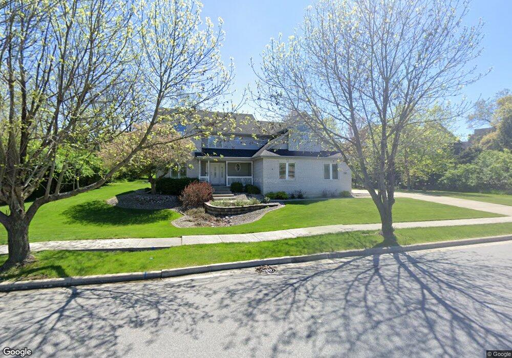
933 Mary Ellen Dr Crown Point, IN 46307
Estimated Value: $619,000 - $700,000
4
Beds
3
Baths
2,800
Sq Ft
$235/Sq Ft
Est. Value
About This Home
This home is located at 933 Mary Ellen Dr, Crown Point, IN 46307 and is currently estimated at $657,327, approximately $234 per square foot. 933 Mary Ellen Dr is a home located in Lake County with nearby schools including Lake Street Elementary School, Robert Taft Middle School, and Crown Point High School.
Ownership History
Date
Name
Owned For
Owner Type
Purchase Details
Closed on
Jan 8, 2014
Sold by
Myszkowski Carl L and Myszkowski Beatrice A
Bought by
Myszkowski Carl L and Myszkowski Beatrice A
Current Estimated Value
Create a Home Valuation Report for This Property
The Home Valuation Report is an in-depth analysis detailing your home's value as well as a comparison with similar homes in the area
Home Values in the Area
Average Home Value in this Area
Purchase History
| Date | Buyer | Sale Price | Title Company |
|---|---|---|---|
| Myszkowski Carl L | -- | None Available |
Source: Public Records
Tax History
| Year | Tax Paid | Tax Assessment Tax Assessment Total Assessment is a certain percentage of the fair market value that is determined by local assessors to be the total taxable value of land and additions on the property. | Land | Improvement |
|---|---|---|---|---|
| 2025 | $5,522 | $571,400 | $111,500 | $459,900 |
| 2024 | $13,541 | $549,800 | $111,500 | $438,300 |
| 2023 | $5,264 | $492,700 | $95,500 | $397,200 |
| 2022 | $5,264 | $469,100 | $95,500 | $373,600 |
| 2021 | $5,036 | $449,100 | $74,300 | $374,800 |
| 2020 | $4,922 | $439,000 | $74,300 | $364,700 |
| 2019 | $5,013 | $443,100 | $74,300 | $368,800 |
| 2018 | $6,632 | $447,300 | $74,300 | $373,000 |
| 2017 | $6,022 | $406,000 | $74,300 | $331,700 |
| 2016 | $5,972 | $396,900 | $74,300 | $322,600 |
| 2014 | $5,338 | $380,100 | $74,300 | $305,800 |
| 2013 | $5,129 | $363,400 | $74,300 | $289,100 |
Source: Public Records
Map
Nearby Homes
- 804 Shannon Dr
- 964 Ryan Ct
- 914 Lillian Russell Ct
- 817 Mary Ellen Dr
- 815 Hayfield Dr
- 1089 George Ade Ct
- 745 Huey Dr
- 3709 W 121st Ave
- 802 Hayfield Dr
- 1140 Hyde Park
- 460 O'Hagan Dr
- 12109 White Oak Dr
- 437 Fairview Ave
- 3516 W 123rd Place
- 629 W South St
- 1002 Gordon Ct
- 780 Williams Ct
- 217 Crestview Ln
- 12275 S Williams Ct
- 123 Elmwood Place
- 938 Cooke Ct
- 925 Mary Ellen Dr
- 936 Cooke Ct
- 932 Cooke Ct
- 936 Mary Ellen Dr
- 936 Mary Ellen Dr
- 928 Mary Ellen Dr
- 940 Mary Ellen Dr
- 928 Cooke Ct
- 940 Cooke Ct
- 921 Mary Ellen Dr
- 924 Mary Ellen Dr
- Lot 306 Mary Ellen Dr
- Lot 308 Mary Ellen Dr
- Lot 269 Mary Ellen Dr
- Lot 107 Mary Ellen Dr
- Lot 115 Mary Ellen Dr
- Lot 108 Mary Ellen Dr
- Lot 305 Mary Ellen Dr
- (Lot 305 Mary Ellen Dr
Your Personal Tour Guide
Ask me questions while you tour the home.