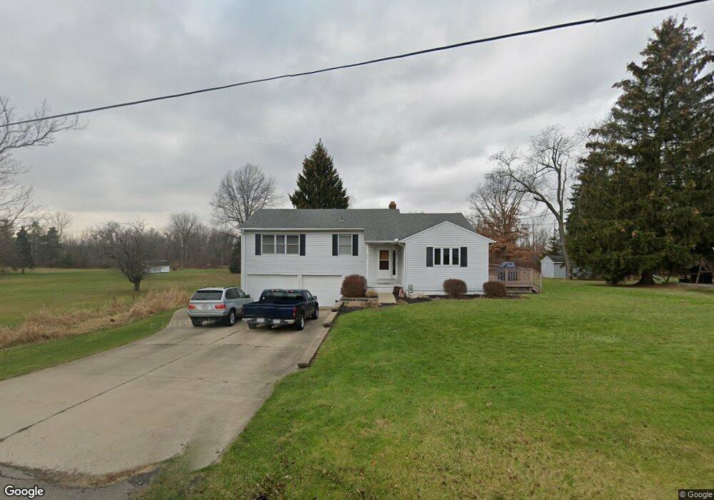
933 State Route 314 N Mansfield, OH 44903
Estimated Value: $215,000 - $336,000
3
Beds
2
Baths
1,677
Sq Ft
$159/Sq Ft
Est. Value
About This Home
This home is located at 933 State Route 314 N, Mansfield, OH 44903 and is currently estimated at $266,716, approximately $159 per square foot. 933 State Route 314 N is a home located in Richland County with nearby schools including Stingel Elementary School, Ontario Middle School, and Ontario High School.
Ownership History
Date
Name
Owned For
Owner Type
Purchase Details
Closed on
May 30, 2013
Sold by
Valgas Ronald D
Bought by
Scott David K
Current Estimated Value
Home Financials for this Owner
Home Financials are based on the most recent Mortgage that was taken out on this home.
Original Mortgage
$103,581
Outstanding Balance
$72,889
Interest Rate
3.25%
Mortgage Type
FHA
Estimated Equity
$193,827
Purchase Details
Closed on
Feb 19, 1991
Sold by
Stadalsky Robert F
Bought by
Valgas Ronald D
Create a Home Valuation Report for This Property
The Home Valuation Report is an in-depth analysis detailing your home's value as well as a comparison with similar homes in the area
Home Values in the Area
Average Home Value in this Area
Purchase History
| Date | Buyer | Sale Price | Title Company |
|---|---|---|---|
| Scott David K | $105,500 | Southern Title | |
| Valgas Ronald D | $67,000 | -- |
Source: Public Records
Mortgage History
| Date | Status | Borrower | Loan Amount |
|---|---|---|---|
| Open | Scott David K | $103,581 |
Source: Public Records
Tax History Compared to Growth
Tax History
| Year | Tax Paid | Tax Assessment Tax Assessment Total Assessment is a certain percentage of the fair market value that is determined by local assessors to be the total taxable value of land and additions on the property. | Land | Improvement |
|---|---|---|---|---|
| 2024 | $2,285 | $45,850 | $6,990 | $38,860 |
| 2023 | $2,285 | $45,850 | $6,990 | $38,860 |
| 2022 | $2,103 | $36,310 | $6,360 | $29,950 |
| 2021 | $2,107 | $36,310 | $6,360 | $29,950 |
| 2020 | $2,249 | $36,310 | $6,360 | $29,950 |
| 2019 | $2,106 | $30,780 | $5,390 | $25,390 |
| 2018 | $1,788 | $30,780 | $5,390 | $25,390 |
| 2017 | $1,763 | $30,780 | $5,390 | $25,390 |
| 2016 | $1,765 | $30,690 | $5,230 | $25,460 |
| 2015 | $1,765 | $30,690 | $5,230 | $25,460 |
| 2014 | $1,767 | $30,690 | $5,230 | $25,460 |
| 2012 | $1,656 | $31,640 | $5,390 | $26,250 |
Source: Public Records
Map
Nearby Homes
- 832 State Route 314 N
- 0 Rudy Rd
- 1671 State Route 314 N
- 56 Lexington Ontario Rd
- 1689 State Route 314
- 1689 Ohio 314
- 3880 Horizon Dr
- 0 Alexander Dr
- 3308 Park Ave W
- 3436 Ridgestone Ct
- 3320 Oakstone Dr
- 3541 Oakstone Dr
- 3251 Cookton Grange Rd
- 1085 Lewis Rd
- 4451 Beam Rd
- 4825 Lincoln Hwy
- 3516 Muirfield
- 3516 Muirfield Dr
- 445 Rudy Rd
- 436 Joy Lynn Ln
- 943 State Route 314 N
- 943 State Route 314 N
- 930 State Route 314 N
- 930 State Route 314 S
- 977 Shelby Ontario Rd
- 963 Shelby Ontario Rd
- 885 State Route 314 N
- 885 State Route 314 N
- 937 Shelby Ontario Rd
- 880 State Route 314 N
- 0 Kings Pointe Dr Lot #7
- 0 Kings Pointe Lot #1
- 1090 Ohio 314
- 862 State Route 314 N
- 901 Shelby Ontario Rd
- 3910 Kings Pointe Dr
- 1037 State Route 314 N
- 3950 Kings Pointe Dr
- 1034 State Route 314 N
- 3880 W 4th St