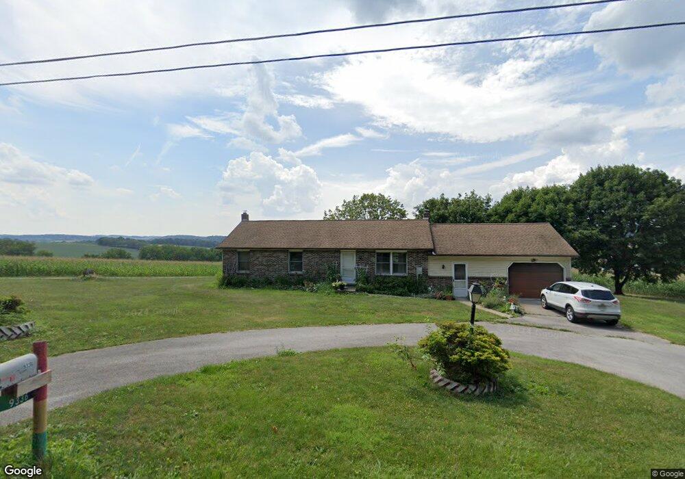
9336 Camp Rd Red Lion, PA 17356
Estimated Value: $303,682 - $331,000
3
Beds
2
Baths
1,344
Sq Ft
$234/Sq Ft
Est. Value
About This Home
This home is located at 9336 Camp Rd, Red Lion, PA 17356 and is currently estimated at $314,421, approximately $233 per square foot. 9336 Camp Rd is a home located in York County with nearby schools including North Hopewell-Winterstown Elementary School, Red Lion Area Junior High School, and Red Lion Area Senior High School.
Ownership History
Date
Name
Owned For
Owner Type
Purchase Details
Closed on
Jun 17, 2022
Sold by
Marks Dorothy E
Bought by
Latimer Ralph E and Latimer Naomi A
Current Estimated Value
Home Financials for this Owner
Home Financials are based on the most recent Mortgage that was taken out on this home.
Original Mortgage
$365,000
Outstanding Balance
$346,307
Interest Rate
5.27%
Mortgage Type
New Conventional
Estimated Equity
-$31,886
Purchase Details
Closed on
May 3, 1964
Sold by
Marks Dorothy E
Bought by
Marks Dorothy E
Create a Home Valuation Report for This Property
The Home Valuation Report is an in-depth analysis detailing your home's value as well as a comparison with similar homes in the area
Home Values in the Area
Average Home Value in this Area
Purchase History
| Date | Buyer | Sale Price | Title Company |
|---|---|---|---|
| Latimer Ralph E | $255,000 | None Listed On Document | |
| Marks Dorothy E | $3,400 | -- |
Source: Public Records
Mortgage History
| Date | Status | Borrower | Loan Amount |
|---|---|---|---|
| Open | Latimer Ralph E | $365,000 | |
| Closed | Latimer Ralph E | $365,000 |
Source: Public Records
Tax History Compared to Growth
Tax History
| Year | Tax Paid | Tax Assessment Tax Assessment Total Assessment is a certain percentage of the fair market value that is determined by local assessors to be the total taxable value of land and additions on the property. | Land | Improvement |
|---|---|---|---|---|
| 2025 | $4,855 | $154,070 | $45,010 | $109,060 |
| 2024 | $4,703 | $154,070 | $45,010 | $109,060 |
| 2023 | $4,703 | $154,070 | $45,010 | $109,060 |
| 2022 | $4,703 | $154,070 | $45,010 | $109,060 |
| 2021 | $4,549 | $154,070 | $45,010 | $109,060 |
| 2020 | $4,549 | $154,070 | $45,010 | $109,060 |
| 2019 | $4,534 | $154,070 | $45,010 | $109,060 |
| 2018 | $4,534 | $154,070 | $45,010 | $109,060 |
| 2017 | $4,534 | $154,070 | $45,010 | $109,060 |
| 2016 | $0 | $154,070 | $45,010 | $109,060 |
| 2015 | -- | $154,070 | $45,010 | $109,060 |
| 2014 | -- | $154,070 | $45,010 | $109,060 |
Source: Public Records
Map
Nearby Homes
- 786 Arbor Dr
- 0 Oak Ridge Ave
- 0 Swamp Hollow Ln
- 290 Neff Rd
- 705 Summit Dr
- 250 Country Ridge Dr
- 260 Country Ridge Dr
- 175 Country Ridge Dr
- 209 Forest Hills Rd
- 126 Country Ridge Dr
- 8219 Lehman Rd
- 630 Woodland Ave
- 11983 Tree Ln
- 117 S Park St
- 620 Boundary Ave
- 28 Pleasant Ave
- 1 N Duke St
- 116 S Franklin St
- 18 E Howard St
- 430 E Maple St