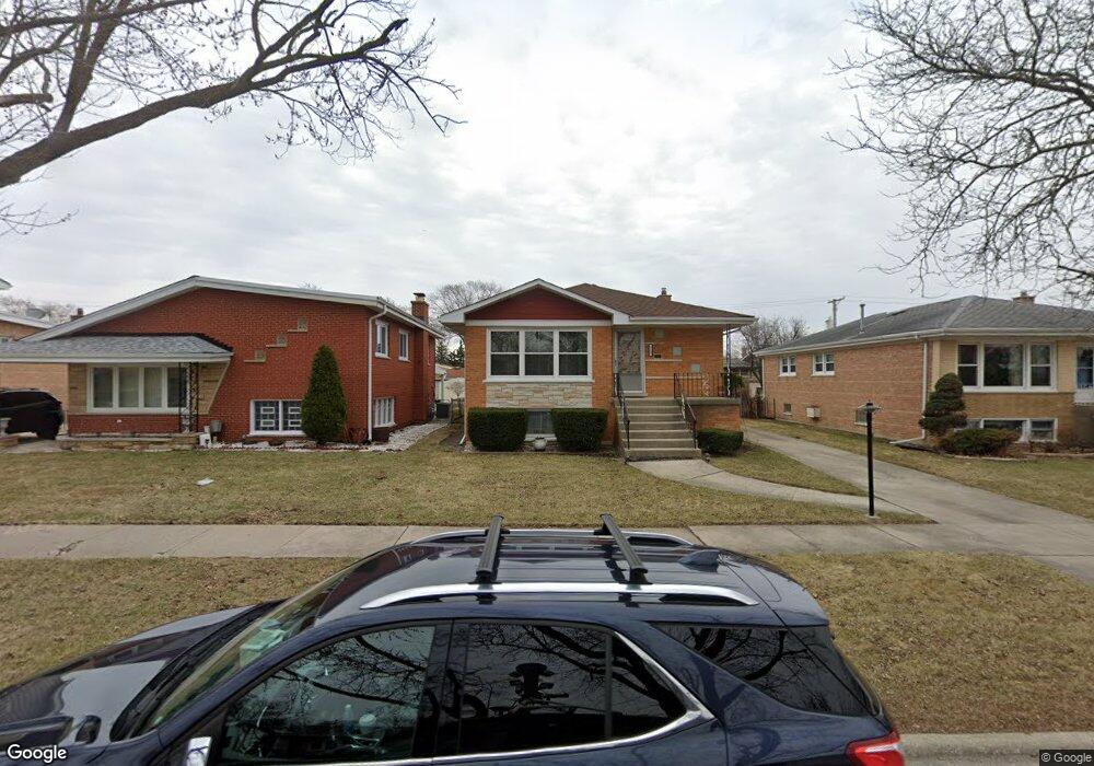
9337 Massasoit Ave Oak Lawn, IL 60453
Estimated Value: $299,000 - $348,000
3
Beds
1
Bath
1,334
Sq Ft
$235/Sq Ft
Est. Value
About This Home
This home is located at 9337 Massasoit Ave, Oak Lawn, IL 60453 and is currently estimated at $313,299, approximately $234 per square foot. 9337 Massasoit Ave is a home located in Cook County with nearby schools including Harnew Elementary School, Simmons Middle School, and Oak Lawn Community High School.
Ownership History
Date
Name
Owned For
Owner Type
Purchase Details
Closed on
Jan 25, 2021
Sold by
Norkaitis Dalia and Ankus Genovaite
Bought by
Ringys Arturas and Ringys Rasa
Current Estimated Value
Home Financials for this Owner
Home Financials are based on the most recent Mortgage that was taken out on this home.
Original Mortgage
$174,800
Interest Rate
3.12%
Mortgage Type
New Conventional
Create a Home Valuation Report for This Property
The Home Valuation Report is an in-depth analysis detailing your home's value as well as a comparison with similar homes in the area
Home Values in the Area
Average Home Value in this Area
Purchase History
| Date | Buyer | Sale Price | Title Company |
|---|---|---|---|
| Ringys Arturas | $190,000 | Chicago Title |
Source: Public Records
Mortgage History
| Date | Status | Borrower | Loan Amount |
|---|---|---|---|
| Previous Owner | Ringys Arturas | $174,800 |
Source: Public Records
Tax History Compared to Growth
Tax History
| Year | Tax Paid | Tax Assessment Tax Assessment Total Assessment is a certain percentage of the fair market value that is determined by local assessors to be the total taxable value of land and additions on the property. | Land | Improvement |
|---|---|---|---|---|
| 2024 | $6,592 | $26,001 | $3,853 | $22,148 |
| 2023 | $5,555 | $26,001 | $3,853 | $22,148 |
| 2022 | $5,555 | $19,238 | $3,350 | $15,888 |
| 2021 | $6,547 | $19,237 | $3,350 | $15,887 |
| 2020 | $1,986 | $19,237 | $3,350 | $15,887 |
| 2019 | $2,137 | $20,777 | $3,015 | $17,762 |
| 2018 | $2,051 | $20,777 | $3,015 | $17,762 |
| 2017 | $2,044 | $20,777 | $3,015 | $17,762 |
| 2016 | $3,017 | $17,111 | $2,512 | $14,599 |
| 2015 | $3,145 | $17,111 | $2,512 | $14,599 |
| 2014 | $3,052 | $17,111 | $2,512 | $14,599 |
| 2013 | $2,846 | $20,386 | $2,512 | $17,874 |
Source: Public Records
Map
Nearby Homes
- 9422 Central Ave
- 9520 S Mayfield Ave Unit N105
- 9542 Massasoit Ave
- 9228 S 55th Ct
- 9542 Parkside Ave
- 9540 S Mayfield Ave Unit 103S
- 9239 S 55th Ct
- 9258 Austin Ave
- 9600 Central Ave
- 9545 Southwest Hwy Unit 5
- 9429 S 55th Ave
- 5810 W 97th St
- 9609 S Austin Ave Unit 1E
- 9100 Lynwood Dr
- 9624 W Shore Dr
- 9716 Massasoit Ave
- 9001 Major Ave
- 9704 W Shore Dr
- 9712 W Shore Dr
- 5840 W 90th St
- 9333 Massasoit Ave
- 9341 Massasoit Ave
- 9329 Massasoit Ave
- 9345 Massasoit Ave
- 9336 Major Ave
- 9332 Major Ave
- 9340 Major Ave
- 9325 Massasoit Ave
- 9328 Major Ave
- 9344 Major Ave
- 9336 Massasoit Ave
- 9321 Massasoit Ave
- 9324 Major Ave
- 9340 Massasoit Ave
- 9332 Massasoit Ave
- 9401 Massasoit Ave
- 9344 Massasoit Ave
- 9328 Massasoit Ave
- 9320 Major Ave
- 9317 Massasoit Ave