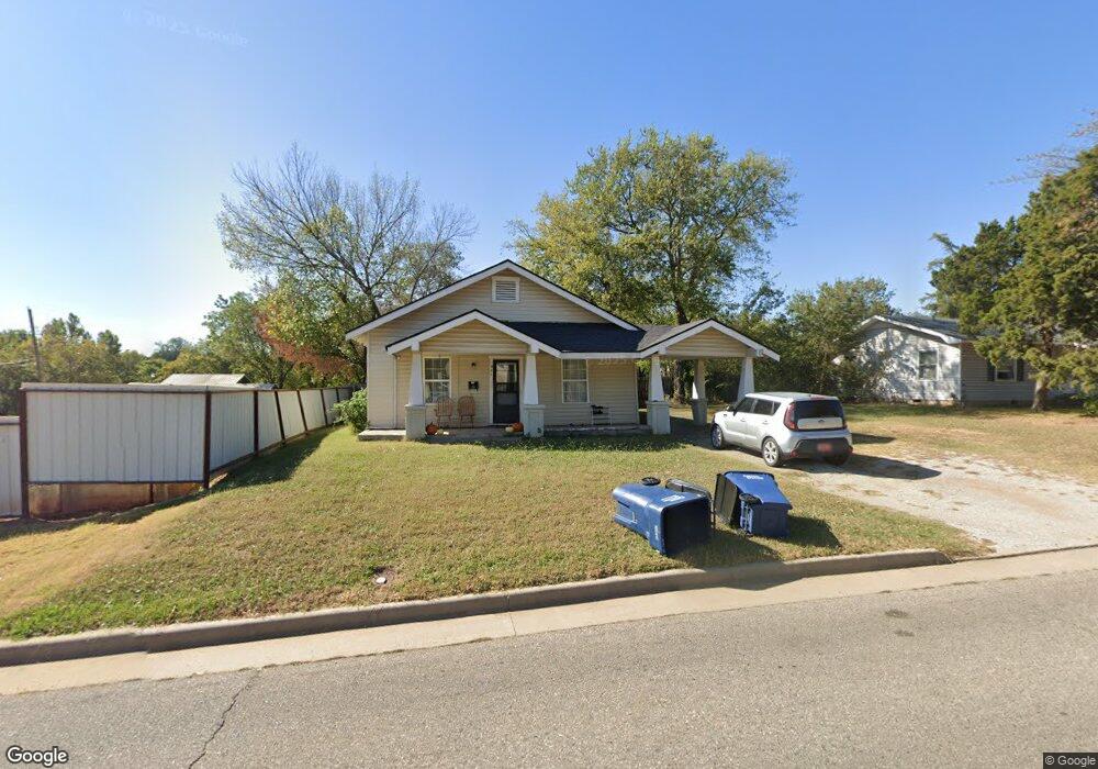
934 N Union Ave Shawnee, OK 74801
Estimated Value: $75,000 - $99,000
3
Beds
1
Bath
1,180
Sq Ft
$75/Sq Ft
Est. Value
About This Home
This home is located at 934 N Union Ave, Shawnee, OK 74801 and is currently estimated at $88,017, approximately $74 per square foot. 934 N Union Ave is a home located in Pottawatomie County with nearby schools including Sequoyah Elementary School, Shawnee Middle School, and Shawnee High School.
Ownership History
Date
Name
Owned For
Owner Type
Purchase Details
Closed on
Jul 9, 2025
Sold by
Kaye Steele Harrod Family Revocable Trus and Kaye Steele Harrod Family Trust
Bought by
Mrz Lizzies Home Rentals Llc
Current Estimated Value
Purchase Details
Closed on
Sep 21, 2012
Sold by
Rowan Kimberly M and Rowan Charles E
Bought by
The Kaye Steele Harrod Family Trust
Purchase Details
Closed on
Mar 3, 1997
Sold by
Wilbourne Russell and Wilbourne Carla
Bought by
Rowan Kimberly
Create a Home Valuation Report for This Property
The Home Valuation Report is an in-depth analysis detailing your home's value as well as a comparison with similar homes in the area
Home Values in the Area
Average Home Value in this Area
Purchase History
| Date | Buyer | Sale Price | Title Company |
|---|---|---|---|
| Mrz Lizzies Home Rentals Llc | -- | None Listed On Document | |
| Mrz Lizzies Home Rentals Llc | -- | None Listed On Document | |
| Mrz Lizzies Home Rentals Llc | -- | None Listed On Document | |
| The Kaye Steele Harrod Family Trust | $44,500 | None Available | |
| Rowan Kimberly | $13,500 | -- |
Source: Public Records
Tax History Compared to Growth
Tax History
| Year | Tax Paid | Tax Assessment Tax Assessment Total Assessment is a certain percentage of the fair market value that is determined by local assessors to be the total taxable value of land and additions on the property. | Land | Improvement |
|---|---|---|---|---|
| 2024 | $639 | $6,427 | $588 | $5,839 |
| 2023 | $639 | $6,121 | $588 | $5,533 |
| 2022 | $628 | $6,121 | $588 | $5,533 |
| 2021 | $618 | $6,137 | $588 | $5,549 |
| 2020 | $632 | $6,255 | $588 | $5,667 |
| 2019 | $665 | $6,372 | $588 | $5,784 |
| 2018 | $660 | $6,454 | $588 | $5,866 |
| 2017 | $646 | $6,404 | $573 | $5,831 |
| 2016 | $622 | $6,100 | $534 | $5,566 |
| 2015 | $581 | $5,808 | $500 | $5,308 |
| 2014 | $553 | $5,532 | $454 | $5,078 |
Source: Public Records
Map
Nearby Homes
- 1017 N Bdwy Ave
- 434 E Wallace St
- 727 N Beard Ave
- 1003 N Minnesota Ave
- 717 N Broadway Ave
- 1006 N Market Ave
- 735 N Park Ave
- 320 W Dill St
- 1217 N Market Ave
- 317 W Dill St
- 318 W Dill St
- 128 W Ridgewood St
- 0 Independence and Minnesota St
- 920 N Kickapoo Ave
- 730 N Tucker Ave
- 615 N Park Ave
- 1324 N Park Ave
- 810 N Kickapoo Ave
- 1510 N Union Ave
- 907 N Mckinley Ave
- 908 N Union Ave
- 906 N Union Ave
- 938 N Union Ave
- 115 E Burns St
- 902 N Union Ave
- 218 E Bannock St
- 941 N Union Ave
- 941 N Union Ave Unit A
- 941 N Union Ave Unit B
- 941 N Union Ave Unit OK
- 1002 N Union Ave
- 937 N Union Ave
- 829 N Union Ave
- 927 Hobson St
- 923 Hobson St
- 909 Hobson St
- 1004 N Union Ave
- 901 Hobson St
- 1001 N Union Ave
- 931 N Hobson Ave