
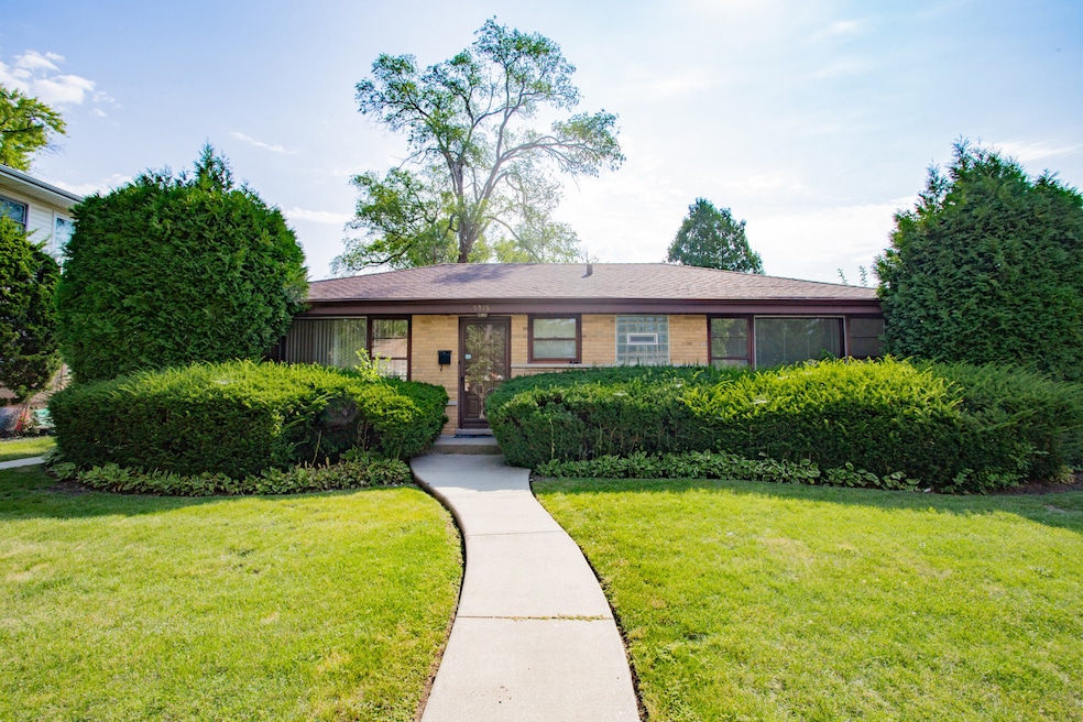


9345 Kildare Ave Skokie, IL 60076
North Skokie NeighborhoodEstimated payment $3,237/month
Total Views
729
3
Beds
2.5
Baths
--
Sq Ft
--
Price per Sq Ft
Highlights
- Very Popular Property
- Property is near a park
- Ranch Style House
- Niles North High School Rated A+
- Recreation Room
- Wood Flooring
About This Home
Charming, solid, and well-maintained home in the desirable Devonshire area. This expansive and versatile residence offers 3 bedrooms, 2 1/2 baths, and a finished basement featuring a spacious rec room plus 2 additional rooms-perfect for an office, guest space, or hobby area. Ample storage throughout. Freshly painted in neutral tones, ready for your creative decorating ideas. Situated on an extra-wide 50' x 120' lot with a 2-car garage. Conveniently located near top-rated schools, shopping malls, parks, and with easy access to major highways. Exceptional opportunity-don't miss it!
Listing Agent
Jameson Sotheby's International Realty License #475131796 Listed on: 08/21/2025
Home Details
Home Type
- Single Family
Est. Annual Taxes
- $9,744
Year Built
- Built in 1955
Lot Details
- Lot Dimensions are 50 x 120
- Paved or Partially Paved Lot
Parking
- 2 Car Garage
Home Design
- Ranch Style House
- Brick Exterior Construction
- Asphalt Roof
Interior Spaces
- Family Room
- Living Room
- Dining Room
- Home Office
- Recreation Room
- Bonus Room
- Carbon Monoxide Detectors
Kitchen
- Range
- Microwave
- Dishwasher
- Granite Countertops
- Disposal
Flooring
- Wood
- Parquet
- Laminate
Bedrooms and Bathrooms
- 3 Bedrooms
- 3 Potential Bedrooms
Laundry
- Laundry Room
- Dryer
- Washer
Basement
- Basement Fills Entire Space Under The House
- Finished Basement Bathroom
Schools
- Highland Elementary School
- Old Orchard Junior High School
- Niles North High School
Utilities
- Central Air
- Heating System Uses Natural Gas
- 100 Amp Service
- Lake Michigan Water
Additional Features
- Patio
- Property is near a park
Map
Create a Home Valuation Report for This Property
The Home Valuation Report is an in-depth analysis detailing your home's value as well as a comparison with similar homes in the area
Home Values in the Area
Average Home Value in this Area
Tax History
| Year | Tax Paid | Tax Assessment Tax Assessment Total Assessment is a certain percentage of the fair market value that is determined by local assessors to be the total taxable value of land and additions on the property. | Land | Improvement |
|---|---|---|---|---|
| 2024 | $9,744 | $39,000 | $8,567 | $30,433 |
| 2023 | $9,483 | $39,000 | $8,567 | $30,433 |
| 2022 | $9,483 | $39,000 | $8,567 | $30,433 |
| 2021 | $8,176 | $29,872 | $5,889 | $23,983 |
| 2020 | $8,095 | $29,872 | $5,889 | $23,983 |
| 2019 | $8,088 | $32,827 | $5,889 | $26,938 |
| 2018 | $7,578 | $28,130 | $5,175 | $22,955 |
| 2017 | $7,633 | $28,130 | $5,175 | $22,955 |
| 2016 | $7,298 | $28,130 | $5,175 | $22,955 |
| 2015 | $6,652 | $23,833 | $4,461 | $19,372 |
| 2014 | $6,497 | $23,833 | $4,461 | $19,372 |
| 2013 | $6,483 | $23,833 | $4,461 | $19,372 |
Source: Public Records
Property History
| Date | Event | Price | Change | Sq Ft Price |
|---|---|---|---|---|
| 08/21/2025 08/21/25 | For Sale | $445,000 | -- | -- |
Source: Midwest Real Estate Data (MRED)
Purchase History
| Date | Type | Sale Price | Title Company |
|---|---|---|---|
| Interfamily Deed Transfer | $232,500 | Chicago Title Insurance Co |
Source: Public Records
Mortgage History
| Date | Status | Loan Amount | Loan Type |
|---|---|---|---|
| Closed | $223,000 | New Conventional | |
| Closed | $110,000 | Credit Line Revolving | |
| Closed | $57,000 | Credit Line Revolving | |
| Closed | $170,800 | Unknown | |
| Closed | $60,000 | Credit Line Revolving | |
| Closed | $250,000 | Unknown | |
| Closed | $177,900 | Unknown | |
| Closed | $261,562 | No Value Available |
Source: Public Records
Similar Homes in the area
Source: Midwest Real Estate Data (MRED)
MLS Number: 12446984
APN: 10-15-217-024-0000
Disclaimer: Certain information contained herein is derived from information provided by parties other than Homes.com. All information provided is deemed reliable, but is not guaranteed to be accurate and should be independently verified.
![]() Based on information submitted to the MLS GRID. All data is obtained from various sources and may not have been verified by broker or MLS GRID. Supplied Open House Information is subject to change without notice. All information should be independently reviewed and verified for accuracy. Properties may or may not be listed by the office/agent presenting the information. Some IDX listings have been excluded from this website.
Based on information submitted to the MLS GRID. All data is obtained from various sources and may not have been verified by broker or MLS GRID. Supplied Open House Information is subject to change without notice. All information should be independently reviewed and verified for accuracy. Properties may or may not be listed by the office/agent presenting the information. Some IDX listings have been excluded from this website.
The Digital Millennium Copyright Act of 1998, 17 U.S.C. § 512 (the “DMCA”) provides recourse for copyright owners who believe that material appearing on the Internet infringes their rights under U.S. copyright law. If you believe in good faith that any content or material made available in connection with our website or services infringes your copyright, you (or your agent) may send us a notice requesting that the content or material be removed, or access to it blocked.
Notices must be sent in writing by email to DMCAnotice@MLSGrid.com.
The DMCA requires that your notice of alleged copyright infringement include the following information:
(1) description of the copyrighted work that is the subject of claimed infringement;
(2) description of the alleged infringing content and information sufficient to permit us to locate the content;
(3) contact information for you, including your address, telephone number and email address;
(4) a statement by you that you have a good faith belief that the content in the manner complained of is not authorized by the copyright owner, or its agent, or by the operation of any law;
(5) a statement by you, signed under penalty of perjury, that the information in the notification is accurate and that you have the authority to enforce the copyrights that are claimed to be infringed; and
(6) a physical or electronic signature of the copyright owner or a person authorized to act on the copyright owner’s behalf. Failure to include all of the above information may result in the delay of the processing of your complaint.
Nearby Homes
- 9333 Kildare Ave
- 9249 Kildare Ave
- 9246 Kildare Ave
- 4310 Church St
- 9330 Kolmar Ave
- 9519 Kolmar Ave
- 9337 Crawford Ave
- 9445 Kenton Ave Unit P30
- 9445 Kenton Ave Unit P14
- 4542 Church St
- 9010 Keeler Ave
- 4234 Suffield Ct
- 9016 Kilbourn Ave
- 9835 Keeler Ave
- 9200 Hamlin Ave
- 9050 Tamaroa Terrace
- 9207 Skokie Blvd Unit 306
- 8850 Karlov Ave
- 9833 Keystone Ave
- 4840 Foster St Unit 304
- 9445 Avers Ave
- 8849 Kostner Terrace
- 9110 Keating Ave Unit 2
- 9029 La Crosse Ave Unit 2A
- 8816 Kenton Ave
- 9008 Skokie Blvd Unit D
- 8949 Skokie Blvd Unit 1
- 9115 Lamon Ave Unit 2N
- 10 Williamsburg Ln
- 9016 La Crosse Ave Unit 2N
- 9029 Lamon Ave Unit 2
- 9003 Lamon Ave Unit 2
- 9016 Lamon Ave Unit 2
- 10 Williamsburg Ct
- 9003 Bronx Ave Unit 2
- 9003 Bronx Ave Unit 1S
- 9003 Bronx Ave Unit 1N
- 8957 Lamon Ave Unit 2N
- 9003 Bronx Ave
- 5020 Church St Unit B