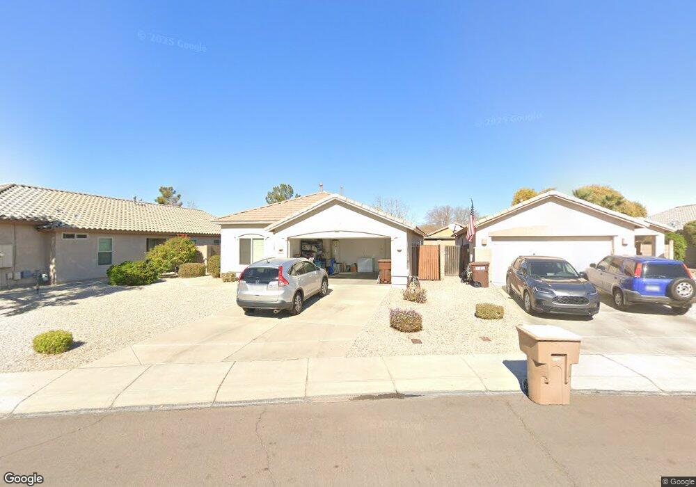
9348 W Deanna Dr Peoria, AZ 85382
Estimated Value: $347,985 - $424,000
--
Bed
2
Baths
1,475
Sq Ft
$274/Sq Ft
Est. Value
About This Home
This home is located at 9348 W Deanna Dr, Peoria, AZ 85382 and is currently estimated at $403,746, approximately $273 per square foot. 9348 W Deanna Dr is a home located in Maricopa County with nearby schools including Coyote Hills Elementary School, Sunrise Mountain High School, and Guidepost Montessori at Peoria.
Ownership History
Date
Name
Owned For
Owner Type
Purchase Details
Closed on
Aug 31, 2000
Sold by
First American Title Insurance Company
Bought by
Schweda Christine L
Current Estimated Value
Home Financials for this Owner
Home Financials are based on the most recent Mortgage that was taken out on this home.
Original Mortgage
$131,050
Outstanding Balance
$47,357
Interest Rate
7.98%
Mortgage Type
VA
Estimated Equity
$356,389
Create a Home Valuation Report for This Property
The Home Valuation Report is an in-depth analysis detailing your home's value as well as a comparison with similar homes in the area
Home Values in the Area
Average Home Value in this Area
Purchase History
| Date | Buyer | Sale Price | Title Company |
|---|---|---|---|
| Schweda Christine L | $127,251 | First American Title |
Source: Public Records
Mortgage History
| Date | Status | Borrower | Loan Amount |
|---|---|---|---|
| Open | Schweda Christine L | $131,050 |
Source: Public Records
Tax History Compared to Growth
Tax History
| Year | Tax Paid | Tax Assessment Tax Assessment Total Assessment is a certain percentage of the fair market value that is determined by local assessors to be the total taxable value of land and additions on the property. | Land | Improvement |
|---|---|---|---|---|
| 2025 | $1,477 | $18,531 | -- | -- |
| 2024 | $1,451 | $17,649 | -- | -- |
| 2023 | $1,451 | $29,960 | $5,990 | $23,970 |
| 2022 | $1,420 | $22,980 | $4,590 | $18,390 |
| 2021 | $1,517 | $21,070 | $4,210 | $16,860 |
| 2020 | $1,533 | $19,880 | $3,970 | $15,910 |
| 2019 | $1,485 | $18,170 | $3,630 | $14,540 |
| 2018 | $1,426 | $17,130 | $3,420 | $13,710 |
| 2017 | $1,429 | $15,610 | $3,120 | $12,490 |
| 2016 | $1,413 | $14,980 | $2,990 | $11,990 |
| 2015 | $1,319 | $14,530 | $2,900 | $11,630 |
Source: Public Records
Map
Nearby Homes
- 9341 W Albert Ln
- 9446 W Albert Ln
- 9541 W Frank Ave
- 9548 W Quail Ave
- 9426 W Melinda Ln
- 9148 W Lone Cactus Dr
- 9574 W Quail Ave
- 20681 N 93rd Ave
- 9582 W Albert Ln
- 9250 W Runion Dr
- 9031 W Adam Ave
- 9529 W Runion Dr
- 9225 W Runion Dr
- 20469 N 95th Dr
- 9333 W Clara Ln
- 20961 N 96th Dr
- 9372 W Louise Dr
- 84XX W Deer Valley Rd
- 9022 W Ross Ave
- 20477 N 91st Dr
- 9344 W Deanna Dr
- 9352 W Deanna Dr
- 9340 W Deanna Dr
- 9356 W Deanna Dr
- 9345 W Albert Ln
- 9336 W Deanna Dr
- 9347 W Deanna Dr
- 9343 W Deanna Dr
- 9332 W Deanna Dr
- 9339 W Deanna Dr
- 9337 W Albert Ln
- 9335 W Deanna Dr
- 9333 W Albert Ln
- 9328 W Deanna Dr
- 9355 W Deanna Dr
- 9340 W Harmony Ln
- 9450 W Frank Ave
- 9331 W Deanna Dr
- 9329 W Albert Ln
- 9344 W Harmony Ln