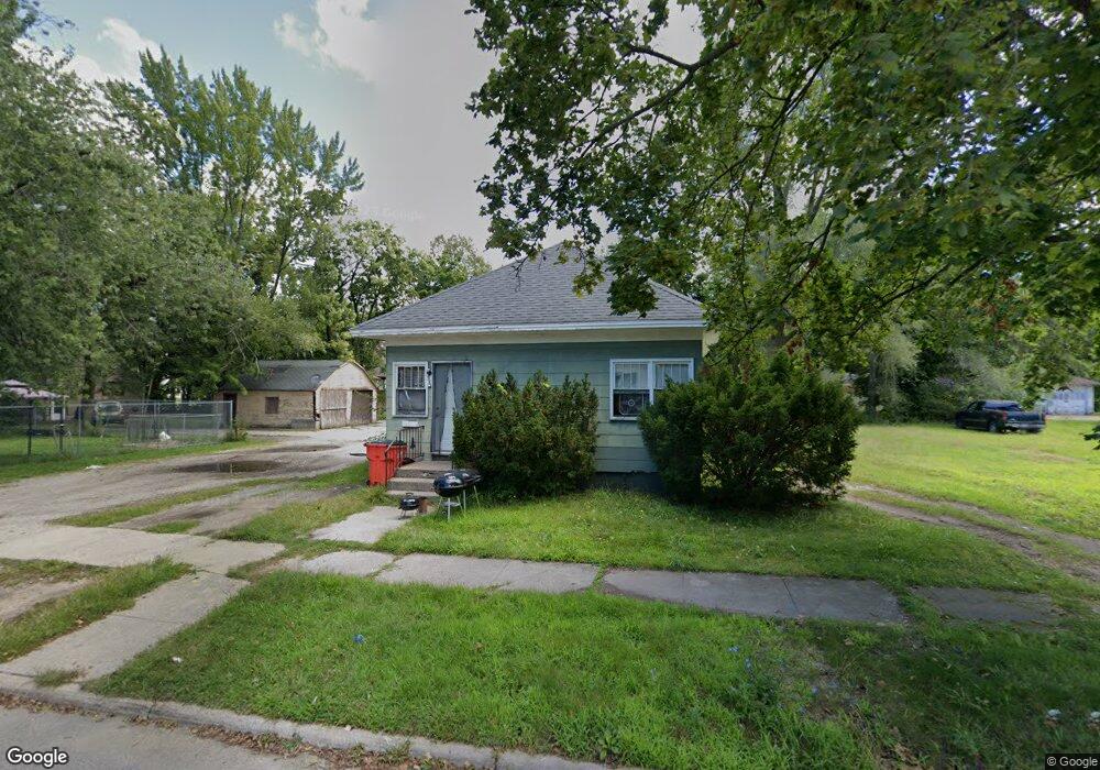
935 Superior St Benton Harbor, MI 49022
Estimated Value: $85,000 - $121,000
3
Beds
1
Bath
1,008
Sq Ft
$100/Sq Ft
Est. Value
About This Home
This home is located at 935 Superior St, Benton Harbor, MI 49022 and is currently estimated at $100,473, approximately $99 per square foot. 935 Superior St is a home located in Berrien County with nearby schools including Fair Plain Middle School, Benton Harbor High School, and Benton Harbor Charter School Academy.
Ownership History
Date
Name
Owned For
Owner Type
Purchase Details
Closed on
Oct 21, 2003
Sold by
Hays Michael J and Hays Rebecca L
Bought by
Benton Rentals Llc
Current Estimated Value
Purchase Details
Closed on
Oct 1, 2002
Purchase Details
Closed on
Apr 30, 1999
Purchase Details
Closed on
Jun 18, 1997
Purchase Details
Closed on
Aug 17, 1994
Purchase Details
Closed on
Jun 18, 1993
Purchase Details
Closed on
Sep 25, 1991
Purchase Details
Closed on
Aug 11, 1987
Purchase Details
Closed on
Sep 24, 1985
Purchase Details
Closed on
Jul 18, 1984
Create a Home Valuation Report for This Property
The Home Valuation Report is an in-depth analysis detailing your home's value as well as a comparison with similar homes in the area
Home Values in the Area
Average Home Value in this Area
Purchase History
| Date | Buyer | Sale Price | Title Company |
|---|---|---|---|
| Benton Rentals Llc | -- | -- | |
| -- | -- | -- | |
| -- | -- | -- | |
| -- | -- | -- | |
| -- | $33,200 | -- | |
| -- | $32,000 | -- | |
| -- | $12,700 | -- | |
| -- | $100 | -- | |
| -- | $12,700 | -- | |
| -- | -- | -- | |
| -- | -- | -- |
Source: Public Records
Tax History
| Year | Tax Paid | Tax Assessment Tax Assessment Total Assessment is a certain percentage of the fair market value that is determined by local assessors to be the total taxable value of land and additions on the property. | Land | Improvement |
|---|---|---|---|---|
| 2025 | $710 | $29,500 | $0 | $0 |
| 2024 | $683 | $25,500 | $0 | $0 |
| 2023 | $546 | $17,400 | $0 | $0 |
| 2022 | $620 | $12,700 | $0 | $0 |
| 2021 | $624 | $12,600 | $700 | $11,900 |
| 2020 | $616 | $12,900 | $0 | $0 |
| 2019 | $605 | $11,400 | $0 | $0 |
| 2018 | $591 | $11,500 | $0 | $0 |
| 2017 | $579 | $9,400 | $0 | $0 |
| 2016 | $569 | $9,500 | $0 | $0 |
| 2015 | $568 | $9,100 | $0 | $0 |
| 2014 | $616 | $11,000 | $0 | $0 |
Source: Public Records
Map
Nearby Homes
- 925 Superior St
- 951 Superior St
- 466 E Empire Ave
- 932 Superior St
- 940 Superior St
- 468 E Empire Ave
- 957 Superior St
- 948 Superior St
- 934 Ogden Ave
- 472 E Empire Ave
- 464 E Empire Ave
- 971 Superior St
- 432 E Empire Ave
- 956 Superior St
- 484 E Empire Ave
- 942 Ogden Ave
- 948 Ogden Ave
- 424 E Empire Ave
- 956 Ogden Ave
- 970 Superior St
Your Personal Tour Guide
Ask me questions while you tour the home.