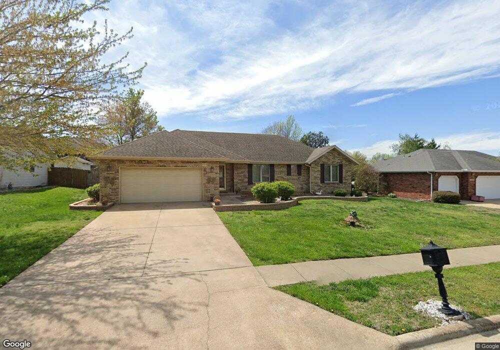
936 W Broad St Republic, MO 65738
Estimated Value: $252,678 - $287,000
3
Beds
2
Baths
1,735
Sq Ft
$157/Sq Ft
Est. Value
About This Home
This home is located at 936 W Broad St, Republic, MO 65738 and is currently estimated at $271,920, approximately $156 per square foot. 936 W Broad St is a home located in Greene County with nearby schools including Lyon Elementary School, Republic Middle School, and Republic High School.
Ownership History
Date
Name
Owned For
Owner Type
Purchase Details
Closed on
Nov 30, 2007
Sold by
Lucas Harvey G and Lucas Carrie
Bought by
Wilkins Maurice
Current Estimated Value
Home Financials for this Owner
Home Financials are based on the most recent Mortgage that was taken out on this home.
Original Mortgage
$128,905
Outstanding Balance
$80,525
Interest Rate
6.4%
Mortgage Type
New Conventional
Estimated Equity
$191,395
Create a Home Valuation Report for This Property
The Home Valuation Report is an in-depth analysis detailing your home's value as well as a comparison with similar homes in the area
Home Values in the Area
Average Home Value in this Area
Purchase History
| Date | Buyer | Sale Price | Title Company |
|---|---|---|---|
| Wilkins Maurice | -- | None Available |
Source: Public Records
Mortgage History
| Date | Status | Borrower | Loan Amount |
|---|---|---|---|
| Open | Wilkins Maurice | $128,905 |
Source: Public Records
Tax History
| Year | Tax Paid | Tax Assessment Tax Assessment Total Assessment is a certain percentage of the fair market value that is determined by local assessors to be the total taxable value of land and additions on the property. | Land | Improvement |
|---|---|---|---|---|
| 2025 | $1,832 | $34,500 | $5,700 | $28,800 |
| 2024 | $1,760 | $31,500 | $4,750 | $26,750 |
| 2023 | $1,726 | $31,500 | $4,750 | $26,750 |
| 2022 | $1,237 | $22,460 | $4,750 | $17,710 |
| 2021 | $1,229 | $22,460 | $4,750 | $17,710 |
| 2020 | $1,230 | $22,120 | $4,750 | $17,370 |
| 2019 | $1,226 | $22,120 | $4,750 | $17,370 |
| 2018 | $1,161 | $20,250 | $3,800 | $16,450 |
| 2017 | $1,151 | $19,400 | $3,800 | $15,600 |
| 2016 | $1,115 | $19,400 | $3,800 | $15,600 |
| 2015 | $1,111 | $19,400 | $3,800 | $15,600 |
| 2014 | $1,071 | $18,530 | $3,800 | $14,730 |
Source: Public Records
Map
Nearby Homes
- 1001 W Broad St
- 473 S Michelle Ave
- 4507 S Farm Road 71
- 000 W Crestview Ln
- 609 S Mckee Ave
- 1135 W Broad St
- 566 S Buxton Ln
- 548 S Buxton Ln
- 2450 Highway 60
- 114 S Eagan St
- 0 Highway 60 Unit 60308100
- 0 Highway 60 Unit 60308095
- 401 S West Ave
- 393 N Ladera Dr
- 421 W Elm St
- 413 W Elm St
- 347 W Elm St
- 626 W Melody Ln
- 1207 S Lakeside Dr
- 511 S Main Ave
- 920 W Broad St
- 954 W Broad St
- 919 W Stanton Dr
- 931 W Stanton Dr
- 903 W Stanton Dr
- 972 W Broad St
- 896 W Broad St
- 945 W Stanton Dr
- 937 W Broad St
- 955 W Broad St
- 921 W Broad St
- 887 W Stanton Dr
- 0 W Stanton Dr Unit 11103790
- 0 W Stanton Dr Unit 11110522
- 979 W Stanton Dr
- 986 W Broad St
- 973 W Broad St
- 872 W Broad St
- 897 W Broad St
- 871 W Stanton Dr
Your Personal Tour Guide
Ask me questions while you tour the home.