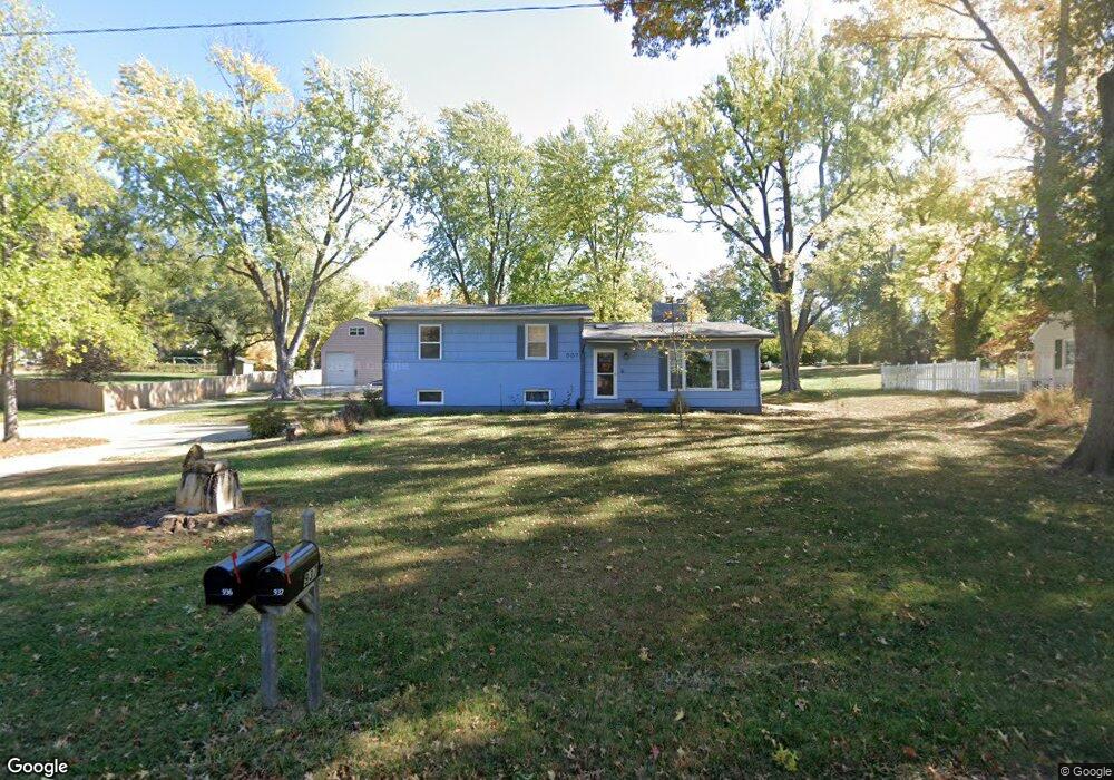
937 Manchester Rd Liberty, MO 64068
Estimated Value: $274,000 - $355,000
3
Beds
2
Baths
1,456
Sq Ft
$219/Sq Ft
Est. Value
About This Home
This home is located at 937 Manchester Rd, Liberty, MO 64068 and is currently estimated at $319,200, approximately $219 per square foot. 937 Manchester Rd is a home located in Clay County with nearby schools including Alexander Doniphan Elementary School, Discovery Middle School, and Liberty High School.
Ownership History
Date
Name
Owned For
Owner Type
Purchase Details
Closed on
Jun 26, 2003
Sold by
Olson Edward A and Olson Judith E
Bought by
Betts Ronald E and Betts Sharon D
Current Estimated Value
Home Financials for this Owner
Home Financials are based on the most recent Mortgage that was taken out on this home.
Original Mortgage
$142,500
Outstanding Balance
$60,630
Interest Rate
5.27%
Mortgage Type
Purchase Money Mortgage
Estimated Equity
$258,570
Purchase Details
Closed on
Jan 22, 1999
Sold by
Morris Thomas A and Morris Merle R
Bought by
Olson Edward A and Olson Judith E
Create a Home Valuation Report for This Property
The Home Valuation Report is an in-depth analysis detailing your home's value as well as a comparison with similar homes in the area
Home Values in the Area
Average Home Value in this Area
Purchase History
| Date | Buyer | Sale Price | Title Company |
|---|---|---|---|
| Betts Ronald E | -- | -- | |
| Olson Edward A | -- | Thomson Title Corp |
Source: Public Records
Mortgage History
| Date | Status | Borrower | Loan Amount |
|---|---|---|---|
| Open | Betts Ronald E | $142,500 |
Source: Public Records
Tax History Compared to Growth
Tax History
| Year | Tax Paid | Tax Assessment Tax Assessment Total Assessment is a certain percentage of the fair market value that is determined by local assessors to be the total taxable value of land and additions on the property. | Land | Improvement |
|---|---|---|---|---|
| 2025 | $3,206 | $45,490 | -- | -- |
| 2024 | $3,206 | $41,690 | -- | -- |
| 2023 | $3,261 | $41,690 | $0 | $0 |
| 2022 | $3,164 | $39,940 | $0 | $0 |
| 2021 | $3,139 | $39,938 | $11,400 | $28,538 |
| 2020 | $2,424 | $28,960 | $0 | $0 |
| 2019 | $2,113 | $25,250 | $0 | $0 |
| 2018 | $1,992 | $23,370 | $0 | $0 |
| 2017 | $1,973 | $23,370 | $5,320 | $18,050 |
| 2016 | $1,973 | $23,370 | $5,320 | $18,050 |
| 2015 | $1,974 | $23,370 | $5,320 | $18,050 |
| 2014 | $1,923 | $22,590 | $5,320 | $17,270 |
Source: Public Records
Map
Nearby Homes
- 918 Amesbury Ave
- 862 Amesbury Ave
- 1124 Amesbury Ave
- 716 Bristol Ct
- 415 Monterey Ave
- 509 Belmont St
- 1218 Canterbury Ln
- 1323 Amesbury Ave
- 420 Belmont St
- 253 S Stewart Rd
- 1507 Amesbury Ave
- 1331 Park Ln
- 1317 Park Ln
- 1209 Liberty Drive Terrace
- 1733 Welleslay Ln
- 1537 Canterbury Ln
- 1304 Wellington Way
- 1327 Easton Ct
- 7908 N Ditzler Ave
- 1025 Orchard Ave
- 1007 Manchester Rd
- 927 Manchester Rd
- 936 Manchester Rd
- 1006 Manchester Rd
- 1021 Manchester Rd
- 920 Manchester Rd
- 905 Manchester Rd
- 1020 Manchester Rd
- 1935 Kings Hwy
- 906 Manchester Rd
- 1037 Manchester Rd
- 936 S Liberty Dr
- 1000 S Liberty Dr
- 1925 Kings Hwy
- 1036 Manchester Rd
- 920 S Liberty Dr
- 1020 S Liberty Dr
- 1950 Kings Hwy
- 906 S Liberty Dr
- 1107 Manchester Rd