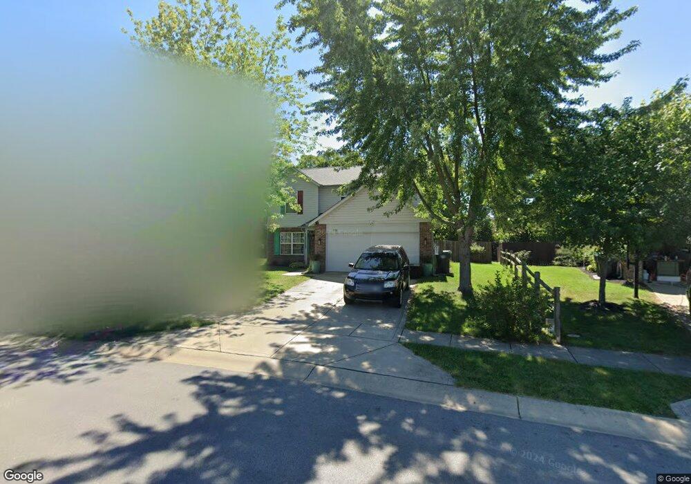
939 Nicole Way Whiteland, IN 46184
Estimated Value: $256,000 - $293,000
4
Beds
3
Baths
1,751
Sq Ft
$160/Sq Ft
Est. Value
About This Home
This home is located at 939 Nicole Way, Whiteland, IN 46184 and is currently estimated at $280,832, approximately $160 per square foot. 939 Nicole Way is a home located in Johnson County with nearby schools including Break-O-Day Elementary School, Clark-Pleasant Middle School, and Whiteland Community High School.
Ownership History
Date
Name
Owned For
Owner Type
Purchase Details
Closed on
Sep 18, 2008
Sold by
Poteet Donna M and Poteet Dennis M
Bought by
Poteet Donna M and Poteet Dennis M
Current Estimated Value
Purchase Details
Closed on
Nov 15, 2005
Sold by
Potect Donna M
Bought by
Fox John M and Fox Lori M
Home Financials for this Owner
Home Financials are based on the most recent Mortgage that was taken out on this home.
Original Mortgage
$23,186
Interest Rate
5.93%
Mortgage Type
Stand Alone Second
Purchase Details
Closed on
Aug 30, 2005
Sold by
Dura Builders Inc
Bought by
Poteet Donna
Home Financials for this Owner
Home Financials are based on the most recent Mortgage that was taken out on this home.
Original Mortgage
$23,186
Interest Rate
5.93%
Mortgage Type
Stand Alone Second
Create a Home Valuation Report for This Property
The Home Valuation Report is an in-depth analysis detailing your home's value as well as a comparison with similar homes in the area
Home Values in the Area
Average Home Value in this Area
Purchase History
| Date | Buyer | Sale Price | Title Company |
|---|---|---|---|
| Poteet Donna M | -- | None Available | |
| Fox John M | -- | None Available | |
| Poteet Donna | -- | Stewart Title |
Source: Public Records
Mortgage History
| Date | Status | Borrower | Loan Amount |
|---|---|---|---|
| Previous Owner | Poteet Donna | $23,186 | |
| Previous Owner | Poteet Donna | $92,746 |
Source: Public Records
Tax History Compared to Growth
Tax History
| Year | Tax Paid | Tax Assessment Tax Assessment Total Assessment is a certain percentage of the fair market value that is determined by local assessors to be the total taxable value of land and additions on the property. | Land | Improvement |
|---|---|---|---|---|
| 2025 | $2,369 | $229,600 | $56,000 | $173,600 |
| 2024 | $2,369 | $227,000 | $56,000 | $171,000 |
| 2023 | $2,314 | $222,400 | $56,000 | $166,400 |
| 2022 | $1,951 | $188,100 | $29,900 | $158,200 |
| 2021 | $1,670 | $160,800 | $29,900 | $130,900 |
| 2020 | $1,482 | $142,200 | $29,900 | $112,300 |
| 2019 | $1,415 | $135,900 | $29,900 | $106,000 |
| 2018 | $1,358 | $137,600 | $25,000 | $112,600 |
| 2017 | $1,293 | $128,300 | $25,000 | $103,300 |
| 2016 | $1,273 | $127,300 | $25,000 | $102,300 |
| 2014 | $1,306 | $129,500 | $30,500 | $99,000 |
| 2013 | $1,306 | $130,600 | $30,500 | $100,100 |
Source: Public Records
Map
Nearby Homes
- 132 Arabian Ct
- 1003 Hilltop Commons Blvd
- 733 Hanover Dr
- 647 Bluestem Cir
- 587 Bluestem Ln
- 114 Tracy Ridge Blvd
- 588 Bluestem Ln
- Lincoln Plan at Crossroads at Southport
- Liberty Plan at Crossroads at Southport
- Rushmore Plan at Crossroads at Southport
- Jefferson Plan at Crossroads at Southport
- Washington Plan at Crossroads at Southport
- 76 Fernleaf Dr
- 652 Mooreland Dr
- 190 Tracy Ridge Blvd
- 240 Shelton Place
- 0 E 700 N Unit MBR22036500
- 1195 Count Turf Ct
- 125 Hilltop Farms Blvd
- 256 Bittersweet Dr