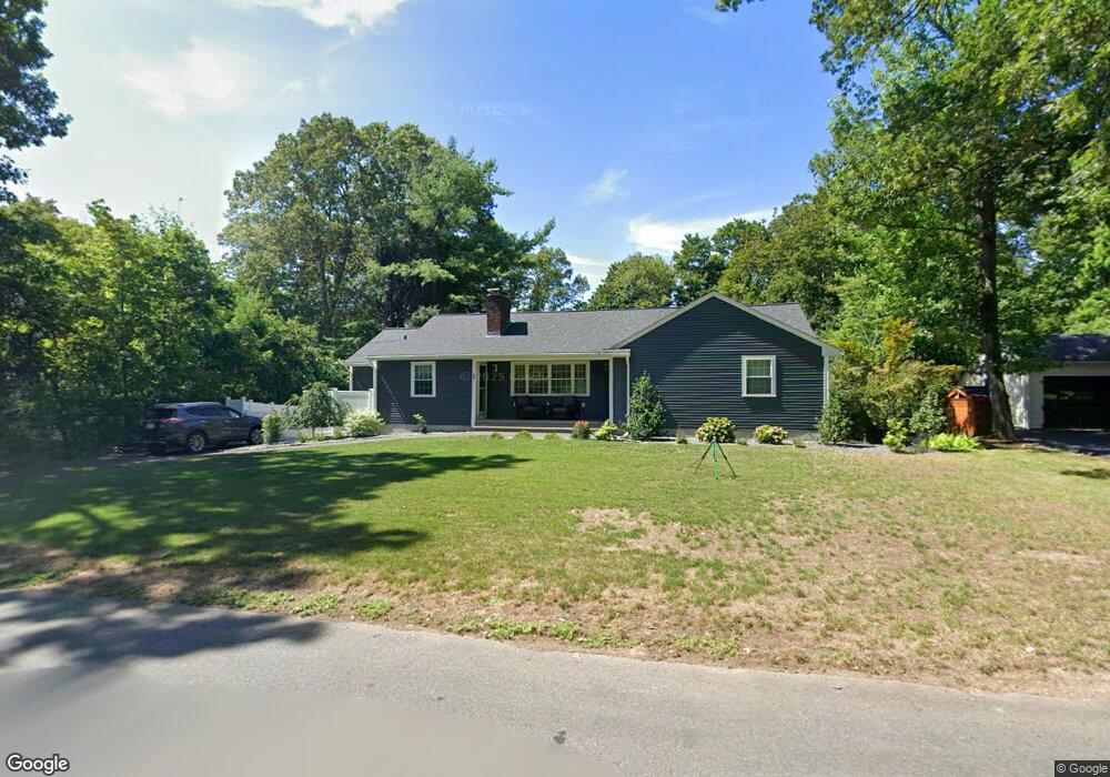
94 Grove St Plainville, MA 02762
Estimated Value: $418,000 - $602,000
3
Beds
2
Baths
1,921
Sq Ft
$276/Sq Ft
Est. Value
About This Home
This home is located at 94 Grove St, Plainville, MA 02762 and is currently estimated at $529,238, approximately $275 per square foot. 94 Grove St is a home located in Norfolk County with nearby schools including Anna Ware Jackson School, Beatrice H. Wood Elementary School, and Cadence Academy Preschool - North Attleborough.
Ownership History
Date
Name
Owned For
Owner Type
Purchase Details
Closed on
Jan 19, 2022
Sold by
Laughman Melissa A and Laughman Keith C
Bought by
Keith C Laughman T C and Keith Laughman
Current Estimated Value
Purchase Details
Closed on
Jun 16, 2021
Sold by
Laughman Keith C
Bought by
Cook Bruce C
Purchase Details
Closed on
Dec 30, 2019
Sold by
Cook Angelina Est and Gehling
Bought by
Cook Bruce C and Laughman Linda J
Purchase Details
Closed on
Dec 29, 2009
Sold by
Cook Bruce C
Bought by
Bmoshe Rockwood Cook I and Bmoshe Laughman
Create a Home Valuation Report for This Property
The Home Valuation Report is an in-depth analysis detailing your home's value as well as a comparison with similar homes in the area
Home Values in the Area
Average Home Value in this Area
Purchase History
| Date | Buyer | Sale Price | Title Company |
|---|---|---|---|
| Keith C Laughman T C | -- | None Available | |
| Cook Bruce C | -- | None Available | |
| Laughman Keith C | -- | None Available | |
| Cook Bruce C | -- | None Available | |
| Bmoshe Rockwood Cook I | -- | -- |
Source: Public Records
Tax History Compared to Growth
Tax History
| Year | Tax Paid | Tax Assessment Tax Assessment Total Assessment is a certain percentage of the fair market value that is determined by local assessors to be the total taxable value of land and additions on the property. | Land | Improvement |
|---|---|---|---|---|
| 2025 | $58 | $502,000 | $241,700 | $260,300 |
| 2024 | $5,512 | $459,300 | $222,400 | $236,900 |
| 2023 | $5,292 | $424,000 | $222,400 | $201,600 |
| 2022 | $4,918 | $350,500 | $210,400 | $140,100 |
| 2021 | $4,783 | $325,400 | $192,100 | $133,300 |
| 2020 | $4,623 | $314,500 | $192,100 | $122,400 |
| 2019 | $4,575 | $305,600 | $183,000 | $122,600 |
| 2018 | $3,979 | $264,200 | $174,200 | $90,000 |
| 2017 | $4,154 | $276,900 | $174,200 | $102,700 |
| 2016 | $4,158 | $280,400 | $174,200 | $106,200 |
| 2015 | $4,018 | $260,600 | $149,700 | $110,900 |
| 2014 | $3,927 | $262,500 | $149,700 | $112,800 |
Source: Public Records
Map
Nearby Homes
- 22 Potter Ave Unit 5
- 6 Hilltop Rd Unit 122
- 230 South St
- 44 Maple Terrace Unit 44
- 2 Woodridge St Unit 2
- 45 Moran St
- 52 George St Unit B
- 35-R Whiting St
- 10 Cliff Dr
- 1066 Mount Hope St
- 3 Field Dr
- 166 E Bacon St Unit 4
- 2 George St Unit C
- 387 South St
- 5 Farm Hill Ln
- 64 Smith St
- 20 South St
- 28 Messenger St
- 8 Al Pace Dr Unit 8
- 3 Serengeti Dr