
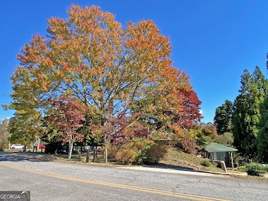
94 Mountain View Dr Dahlonega, GA 30533
Estimated payment $1,979/month
Highlights
- Deck
- Wood Flooring
- No HOA
- Private Lot
- Sun or Florida Room
- Breakfast Bar
About This Home
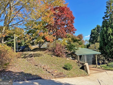
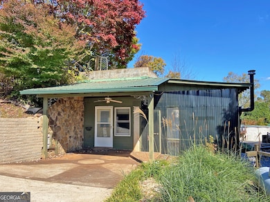
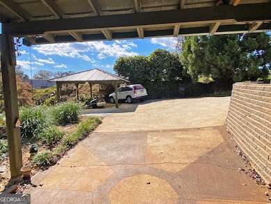
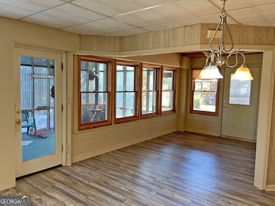
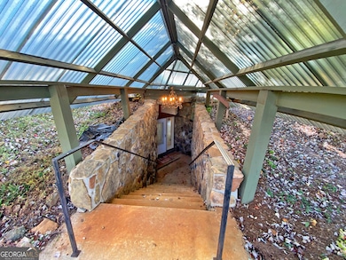
DAHLONEGA UNIQUE - How unique do you ask? How about the only earth-sheltered home in Town? This two bedroom, two bath berm home offers extraordinary energy efficiency and is constructed of the materials one might encounter in a flyover bridge on a highway. The setting is privatized and in harmony with the land. From the street the appearance is of a small, naturalized park. The full-length and glassed back side of the home looks out over the decking and landscaping and down across a grassy and terraced back yard. A cute little ancillary structure offers a sleeping berth and bath. Inside is a surround kitchen, spacious laundry/auxiliary room, and a sunroom. Entry is offered from both the front and the side. The streets are paved, and the parking is concreted. Sidewalks carry you all the way to the Downtown Square and all the delights of Dahlonega. Unique it is, and also unique is the infrequent availability of a home "in Town" Dahlonega.
Home Details
Home Type
- Single Family
Est. Annual Taxes
- $38
Year Built
- Built in 1981
Lot Details
- 0.55 Acre Lot
- Private Lot
Home Design
- Concrete Roof
- Concrete Siding
- Stone Siding
- Stone
Interior Spaces
- 1,260 Sq Ft Home
- 1-Story Property
- Ceiling Fan
- Family Room
- Living Room with Fireplace
- Sun or Florida Room
- Crawl Space
Kitchen
- Breakfast Bar
- Oven or Range
- Dishwasher
Flooring
- Wood
- Laminate
Bedrooms and Bathrooms
- 2 Main Level Bedrooms
- 2 Full Bathrooms
Laundry
- Laundry Room
- Laundry in Hall
- Dryer
- Washer
Parking
- Parking Accessed On Kitchen Level
- Parking Shed
- Side or Rear Entrance to Parking
- Off-Street Parking
Outdoor Features
- Deck
- Outbuilding
Location
- Property is near schools
- City Lot
Schools
- Lumpkin County Elementary And Middle School
- New Lumpkin County High School
Utilities
- Central Heating and Cooling System
- Underground Utilities
- Septic Tank
- High Speed Internet
- Phone Available
Community Details
- No Home Owners Association
Map
Home Values in the Area
Average Home Value in this Area
Tax History
| Year | Tax Paid | Tax Assessment Tax Assessment Total Assessment is a certain percentage of the fair market value that is determined by local assessors to be the total taxable value of land and additions on the property. | Land | Improvement |
|---|---|---|---|---|
| 2024 | $38 | $75,488 | $11,960 | $63,528 |
| 2023 | $83 | $70,947 | $11,960 | $58,987 |
| 2022 | $21 | $64,624 | $11,960 | $52,664 |
| 2021 | $2,017 | $55,429 | $11,960 | $43,469 |
| 2020 | $1,970 | $54,126 | $11,960 | $42,166 |
| 2019 | $160 | $54,126 | $11,960 | $42,166 |
| 2018 | $1,779 | $48,876 | $11,960 | $36,916 |
| 2017 | $0 | $48,652 | $11,960 | $36,692 |
| 2016 | -- | $45,151 | $11,960 | $33,191 |
| 2015 | -- | $45,152 | $11,960 | $33,191 |
| 2014 | -- | $45,654 | $11,960 | $33,694 |
| 2013 | -- | $46,660 | $11,960 | $34,700 |
Property History
| Date | Event | Price | List to Sale | Price per Sq Ft |
|---|---|---|---|---|
| 11/03/2025 11/03/25 | For Sale | $375,000 | -- | $298 / Sq Ft |
Purchase History
| Date | Type | Sale Price | Title Company |
|---|---|---|---|
| Warranty Deed | -- | -- | |
| Deed | $100,000 | -- | |
| Deed | -- | -- | |
| Deed | -- | -- |
Source: Georgia MLS
MLS Number: 10636679
APN: D05-000-064-000
Disclaimer: Certain information contained herein is derived from information provided by parties other than Homes.com. All information provided is deemed reliable, but is not guaranteed to be accurate and should be independently verified.
![]() The data relating to real estate for sale on this web site comes in part from the Broker Reciprocity Program of Georgia MLS. Real estate listings held by brokerage firms other than Redfin are marked with the Broker Reciprocity logo and detailed information about them includes the name of the listing brokers. Information deemed reliable but not guaranteed. Copyright 2025 Georgia MLS. All rights reserved.
The data relating to real estate for sale on this web site comes in part from the Broker Reciprocity Program of Georgia MLS. Real estate listings held by brokerage firms other than Redfin are marked with the Broker Reciprocity logo and detailed information about them includes the name of the listing brokers. Information deemed reliable but not guaranteed. Copyright 2025 Georgia MLS. All rights reserved.
- 10 Rustin Ridge
- 97 Beaumont Dr
- 502 Wimpy Mill Rd
- 22 Honeysuckle Ln
- 95 Jones St
- 399 N Chestatee St
- 0 Highway 19 N Unit 10594984
- 490 N Hall Rd
- 315 Church St
- LOT 6 Sky Country Rd
- 159 Misty Way
- 0 S Chestatee St Unit 10619536
- 168 W Main St
- 0 Timberlane Dr Unit 10483799
- 0 Timberlane Dr Unit 7479971
- 1392 S Chestatee St
- 6480A Highway 52
- 329 Morrison Moore Pkwy E
- 149 Highland Rd S
- 502 Wimpy Mill Rd
- 215 Stephens St
- 3 Bellamy Place
- 113 Roberta Ave
- 4000 Peaks Cir
- 25 Stoneybrook Dr
- 211 Stoneybrook Dr
- 364 Stoneybrook Dr
- 635 Ben Higgins Rd
- 16 Rustin Ridge
- 235 Yahoola Rd
- 2385 Porter Springs Rd
- 2331 Highway 52 W Unit Suite E
- 34 Souther Trail
- 99 Strawberry Ln
- 30 Rustin Ridge
- 55 Silver Fox Ct
- 1560 Grindle Bridge Rd
- 56 Puff Hill Dr
- 7065 Dawsonville Hwy Unit A
