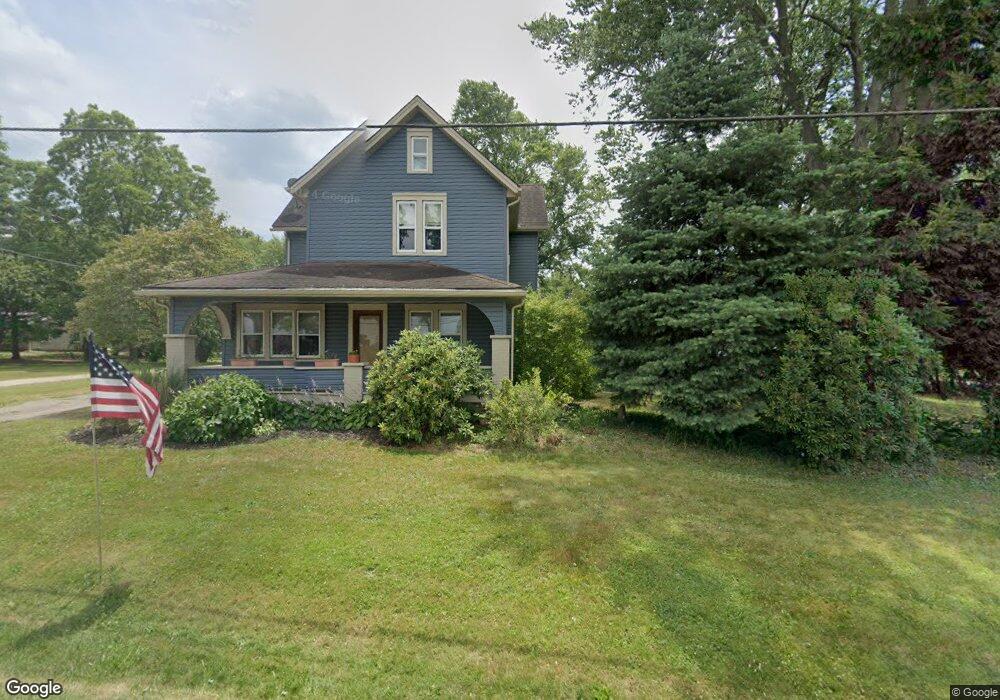
9400 Louisville St Louisville, OH 44641
Estimated Value: $263,526 - $295,000
3
Beds
2
Baths
2,072
Sq Ft
$131/Sq Ft
Est. Value
About This Home
This home is located at 9400 Louisville St, Louisville, OH 44641 and is currently estimated at $272,132, approximately $131 per square foot. 9400 Louisville St is a home located in Stark County with nearby schools including Louisville High School and St. Thomas Aquinas High School & Middle School.
Ownership History
Date
Name
Owned For
Owner Type
Purchase Details
Closed on
Mar 10, 2017
Sold by
Woolf Stephen F and Woolf Christine M
Bought by
Gerber Aaron and Gerber Cara
Current Estimated Value
Home Financials for this Owner
Home Financials are based on the most recent Mortgage that was taken out on this home.
Original Mortgage
$137,373
Outstanding Balance
$113,980
Interest Rate
4.19%
Mortgage Type
FHA
Estimated Equity
$158,152
Purchase Details
Closed on
Aug 20, 1993
Create a Home Valuation Report for This Property
The Home Valuation Report is an in-depth analysis detailing your home's value as well as a comparison with similar homes in the area
Home Values in the Area
Average Home Value in this Area
Purchase History
| Date | Buyer | Sale Price | Title Company |
|---|---|---|---|
| Gerber Aaron | $136,000 | None Available | |
| -- | $75,000 | -- |
Source: Public Records
Mortgage History
| Date | Status | Borrower | Loan Amount |
|---|---|---|---|
| Open | Gerber Aaron | $137,373 |
Source: Public Records
Tax History Compared to Growth
Tax History
| Year | Tax Paid | Tax Assessment Tax Assessment Total Assessment is a certain percentage of the fair market value that is determined by local assessors to be the total taxable value of land and additions on the property. | Land | Improvement |
|---|---|---|---|---|
| 2025 | -- | $79,000 | $18,480 | $60,520 |
| 2024 | -- | $79,000 | $18,480 | $60,520 |
| 2023 | $2,294 | $47,190 | $13,060 | $34,130 |
| 2022 | $2,300 | $47,190 | $13,060 | $34,130 |
| 2021 | $2,307 | $47,190 | $13,060 | $34,130 |
| 2020 | $1,968 | $42,530 | $11,760 | $30,770 |
| 2019 | $1,976 | $42,530 | $11,760 | $30,770 |
| 2018 | $1,969 | $42,530 | $11,760 | $30,770 |
| 2017 | $1,919 | $39,560 | $10,710 | $28,850 |
| 2016 | $1,372 | $28,890 | $7,000 | $21,890 |
| 2015 | $1,376 | $28,890 | $7,000 | $21,890 |
| 2014 | $1,298 | $25,210 | $6,090 | $19,120 |
| 2013 | $652 | $25,210 | $6,090 | $19,120 |
Source: Public Records
Map
Nearby Homes
- 203 Brookfield St
- 2015 E Main St
- 1812 E Broad St
- 2110 Edmar St
- 1715 High St
- 5495 Meese Rd NE
- 0 Michigan Blvd
- 3390 Meese Rd NE
- 308 Superior St
- 641 S Nickelplate St
- 5765 Maplegrove St
- 520 S Silver St
- 1170 Winding Ridge Ave
- 6052 N Nickelplate St
- 728 E Broad St
- 910 Crosswyck Cir
- 325 Lincoln Ave
- 822 Sand Lot Cir
- 908 Sand Lot Cir
- 204 E Broad St
- 9368 Louisville St
- 9420 Louisville St
- 9444 Louisville St
- 9464 Louisville St
- 9474 Louisville St
- 4415 Swallen Ave
- 9305 Louisville St
- 9580 Louisville St
- 9595 Louisville St
- 9609 Sommerville St
- 9611 Louisville St
- 4375 Swallen Ave
- 4375 Swallen Ave
- 9604 Louisville St NE
- 9626 Sommerville St
- 9604 Louisville St
- 4440 Swallen Ave
- 4420 Swallen Ave
- 9636 Louisville St
- 9644 Sommerville St