9424 Michael Dr Clinton, MD 20735
Estimated Value: $371,000 - $430,586
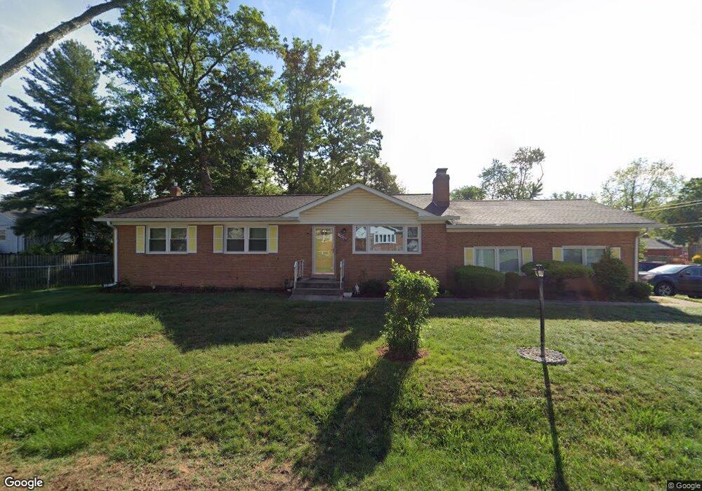
About This Home
This home is located at 9424 Michael Dr, Clinton, MD 20735 and is currently estimated at $410,397, approximately $305 per square foot. 9424 Michael Dr is a home located in Prince George's County with nearby schools including Waldon Woods Elementary School, Stephen Decatur Middle School, and Surrattsville High School.
Ownership History
We collect this data history from publicly available records. To have your information removed, we recommend requesting removal directly through your county’s website.
Purchase Details
Purchase Details
Home Financials for this Owner
Home Financials are based on the most recent Mortgage that was taken out on this home.Purchase Details
Home Values in the Area
Average Home Value in this Area
Purchase History
We collect this data history from publicly available records. To have your information removed, we recommend requesting removal directly through your county’s website.
| Date | Buyer | Sale Price | Title Company |
|---|---|---|---|
| $286,900 | -- | ||
| $144,950 | -- | ||
| $110,000 | -- |
Mortgage History
We collect this data history from publicly available records. To have your information removed, we recommend requesting removal directly through your county’s website.
| Date | Status | Borrower | Loan Amount |
|---|---|---|---|
| Previous Owner | $137,250 |
Tax History
We collect this data history from publicly available records. To have your information removed, we recommend requesting removal directly through your county’s website.
| Year | Tax Paid | Tax Assessment Tax Assessment Total Assessment is a certain percentage of the fair market value that is determined by local assessors to be the total taxable value of land and additions on the property. | Land | Improvement |
|---|---|---|---|---|
| 2025 | $4,683 | $343,400 | $101,200 | $242,200 |
| 2024 | $4,683 | $325,667 | -- | -- |
| 2023 | $4,517 | $307,933 | $0 | $0 |
| 2022 | $4,306 | $290,200 | $101,200 | $189,000 |
| 2021 | $4,139 | $280,200 | $0 | $0 |
| 2020 | $5,932 | $270,200 | $0 | $0 |
| 2019 | $5,571 | $260,200 | $100,600 | $159,600 |
| 2018 | $5,303 | $248,567 | $0 | $0 |
| 2017 | $3,748 | $236,933 | $0 | $0 |
| 2016 | -- | $225,300 | $0 | $0 |
| 2015 | $3,341 | $219,933 | $0 | $0 |
| 2014 | $3,341 | $214,567 | $0 | $0 |
Map
- 9401 Pine View Ln
- 9604 Lormar Ct
- 6706 Surratts Rd
- 6810 Surratts Rd
- 9515 Pin Oak St
- 6510 Horseshoe Rd
- 9904 Raintree Way
- F Gwynndale Dr
- 6704 Seabird Ct
- 6317 Hellen Lee Dr
- 9003 Woodyard Rd
- 7318 Rotunda Ct
- 7504 Foxcroft Ct
- 7604 Fox Hunt Ct
- 9312 Fox Run Dr
- 7606 Huntsman Ct
- 9015 Spring Acres Rd
- 8805 Mimosa Ave
- 6624 Bullrush Ct
- 6200 Terence Dr
- 9505 Hale Dr
- 9412 Michael Dr
- 9425 Michael Dr
- 9410 Pine View Ln
- 9501 Hale Dr
- 9500 Michael Dr
- 9504 Hale Dr
- 9408 Pine View Ln
- 9521 Hale Dr
- 9501 Michael Dr
- 9437 Hale Dr
- 9501 Beverly Ave
- 9406 Pine View Ln
- 9502 Michael Dr
- 9520 Hale Dr
- 9408 Michael Dr
- 9409 Michael Dr
- 9525 Hale Dr
- 9411 Michael Dr
- 9503 Beverly Ave
Ask me questions while you tour the home.