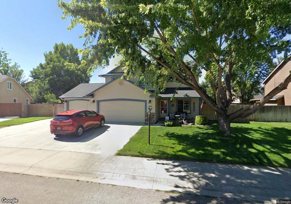
943 N Lambert Way Meridian, ID 83642
Northwest Meridian NeighborhoodEstimated Value: $523,000 - $536,215
4
Beds
3
Baths
2,054
Sq Ft
$257/Sq Ft
Est. Value
About This Home
This home is located at 943 N Lambert Way, Meridian, ID 83642 and is currently estimated at $528,054, approximately $257 per square foot. 943 N Lambert Way is a home located in Ada County with nearby schools including Chaparral Elementary School, Meridian Middle School, and Meridian High School.
Ownership History
Date
Name
Owned For
Owner Type
Purchase Details
Closed on
Jan 28, 2009
Sold by
Freshstart Solutions Inc
Bought by
Mortensen Thomas and Mortensen Jill R
Current Estimated Value
Home Financials for this Owner
Home Financials are based on the most recent Mortgage that was taken out on this home.
Original Mortgage
$187,750
Outstanding Balance
$118,934
Interest Rate
5.14%
Mortgage Type
VA
Estimated Equity
$409,120
Purchase Details
Closed on
Oct 29, 2008
Sold by
Glushchak Vladimir V
Bought by
Fresh Start Solutions Inc
Create a Home Valuation Report for This Property
The Home Valuation Report is an in-depth analysis detailing your home's value as well as a comparison with similar homes in the area
Home Values in the Area
Average Home Value in this Area
Purchase History
| Date | Buyer | Sale Price | Title Company |
|---|---|---|---|
| Mortensen Thomas | -- | Pioneer | |
| Fresh Start Solutions Inc | -- | None Available |
Source: Public Records
Mortgage History
| Date | Status | Borrower | Loan Amount |
|---|---|---|---|
| Open | Mortensen Thomas | $187,750 |
Source: Public Records
Tax History Compared to Growth
Tax History
| Year | Tax Paid | Tax Assessment Tax Assessment Total Assessment is a certain percentage of the fair market value that is determined by local assessors to be the total taxable value of land and additions on the property. | Land | Improvement |
|---|---|---|---|---|
| 2025 | $1,711 | $484,400 | -- | -- |
| 2024 | $1,646 | $468,700 | -- | -- |
| 2023 | $1,646 | $431,300 | $0 | $0 |
| 2022 | $2,336 | $565,000 | $0 | $0 |
| 2021 | $2,006 | $407,600 | $0 | $0 |
| 2020 | $1,885 | $326,200 | $0 | $0 |
| 2019 | $2,213 | $304,600 | $0 | $0 |
| 2018 | $1,909 | $263,500 | $0 | $0 |
| 2017 | $1,719 | $239,300 | $0 | $0 |
| 2016 | $1,651 | $223,400 | $0 | $0 |
| 2015 | $1,467 | $210,400 | $0 | $0 |
| 2012 | -- | $154,100 | $0 | $0 |
Source: Public Records
Map
Nearby Homes
- 722 Buroak Dr
- 798 Buroak Dr
- Plan 2755 at Pivot Pointe
- Plan 2605 at Pivot Pointe
- Plan 2330 Modeled at Pivot Pointe
- Plan 2070 at Pivot Pointe
- Plan 1870 at Pivot Pointe
- Plan 1570 Modeled at Pivot Pointe
- 4636 W Gillette St
- 729 N Traquair Place
- 4659 W Blue Creek Ct
- 4089 W Dover Dr
- 4748 W Topeka Ln
- 755 N Manship Ave
- 1233 N Cedar Creek Place
- 4521 W Quaker Ridge Dr
- 3698 W Dover Dr
- 3646 W Dover Dr
- 1690 N Henderson Ave
- 4887 W Quaker Ridge St
- 961 N Lambert Way
- 925 N Lambert Way
- 4570 W Hearst Dr
- 4560 W Hearst Dr
- 4590 W Hearst Dr
- 4542 W Hearst Dr
- 961 N Stronghold Ave
- 979 N Lambert Way
- 4642 W Hearst Dr
- 989 N Stronghold Ave
- 934 N Stronghold Ave
- 4569 W Hearst Dr
- 4587 W Hearst Dr
- 898 N Stronghold Ave
- 952 N Stronghold Ave
- 4551 W Hearst Dr
- 4615 W Hearst Dr
- 4654 W Hearst Dr
- 997 N Lambert Way
- 4533 W Hearst Dr