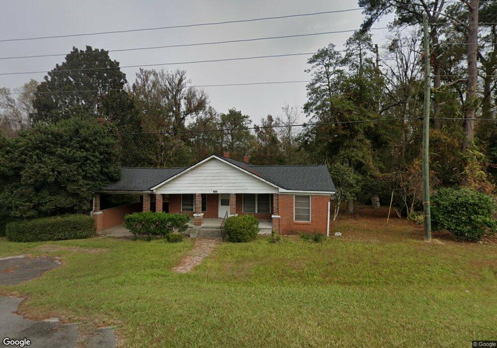
9448 E Oglethorpe Hwy Midway, GA 31320
Estimated Value: $244,000 - $324,000
3
Beds
2
Baths
1,996
Sq Ft
$144/Sq Ft
Est. Value
About This Home
This home is located at 9448 E Oglethorpe Hwy, Midway, GA 31320 and is currently estimated at $287,433, approximately $144 per square foot. 9448 E Oglethorpe Hwy is a home with nearby schools including Liberty Elementary School, Midway Middle School, and Liberty County High School.
Ownership History
Date
Name
Owned For
Owner Type
Purchase Details
Closed on
May 28, 2013
Sold by
Mcgriff Carrie
Bought by
Powell Johnny C and Mcgriff Carrie
Current Estimated Value
Purchase Details
Closed on
Oct 26, 1949
Sold by
Morrison Dewitt F
Bought by
Morrison Dewitt F
Purchase Details
Closed on
Jun 26, 1948
Sold by
Morrison Dewitt F
Bought by
Morrison Dewitt F
Purchase Details
Closed on
May 11, 1943
Bought by
Morrison Dewitt F
Create a Home Valuation Report for This Property
The Home Valuation Report is an in-depth analysis detailing your home's value as well as a comparison with similar homes in the area
Home Values in the Area
Average Home Value in this Area
Purchase History
| Date | Buyer | Sale Price | Title Company |
|---|---|---|---|
| Powell Johnny C | -- | -- | |
| Morrison Dewitt F | -- | -- | |
| Morrison Dewitt F | -- | -- | |
| Morrison Dewitt F | -- | -- |
Source: Public Records
Tax History Compared to Growth
Tax History
| Year | Tax Paid | Tax Assessment Tax Assessment Total Assessment is a certain percentage of the fair market value that is determined by local assessors to be the total taxable value of land and additions on the property. | Land | Improvement |
|---|---|---|---|---|
| 2024 | $2,642 | $62,842 | $25,323 | $37,519 |
| 2023 | $2,642 | $58,707 | $25,323 | $33,384 |
| 2022 | $2,062 | $52,243 | $25,323 | $26,920 |
| 2021 | $1,954 | $49,653 | $25,323 | $24,330 |
| 2020 | $1,979 | $50,155 | $25,323 | $24,832 |
| 2019 | $1,947 | $50,657 | $25,323 | $25,334 |
| 2018 | $1,943 | $51,158 | $25,323 | $25,835 |
| 2017 | $2,192 | $51,660 | $25,323 | $26,337 |
| 2016 | $1,846 | $52,162 | $25,323 | $26,839 |
| 2015 | $2,519 | $51,206 | $24,368 | $26,839 |
| 2014 | $2,519 | $70,921 | $42,359 | $28,562 |
| 2013 | -- | $35,978 | $9,464 | $26,514 |
Source: Public Records
Map
Nearby Homes
- 0 E Oglethorpe Unit 10592168
- 0 E Oglethorpe Unit SA333651
- 0 E Oglethorpe Unit 153327
- 124 Denham Ln
- 124 Denham Ln
- 9 Ashlynn Ln
- 10 Katelynn Ln
- 266 River Bend Dr
- 327 River Bend Dr
- 0000 E Oglethorpe Hwy
- 90 Charleston Ct
- 182 Gloucester Dr
- 0 S Coastal Hwy
- 175 U S 17
- 984 Stone Ct
- 1123 Stone Ct
- 140 Kettle Creek Ln
- 307 Cottage Loop
- 177 Cottage Loop
- 62 Carver Way
- 0 E Oglethorpe Unit 53387
- 0 E Oglethorpe Unit 60347
- 0 E Oglethorpe Unit 72122
- 0 E Olgethorpe Hwy Unit 75134
- 0 E Oglethorpe Unit 92800
- 0 E Oglethorpe Unit 93739
- 0 E Oglethorpe Unit 107305
- 0 E Oglethorpe Unit 119865
- 0 E Oglethorpe Unit 138412
- 0 E Oglethorpe Unit 159465
- 0 E Oglethorpe Unit 169671
- 0 E Oglethorpe Unit 172681
- 0 E Oglethorpe Unit 178312
- 0 E Oglethorpe Unit 179421
- 0 E Oglethorpe Unit 159154
- 0 E Oglethorpe Unit 10444641
- 0 E Oglethorpe Unit 324847
- 0 E Oglethorpe Unit 306920
- 0 E Oglethorpe Unit 310041
- 0 E Oglethorpe Unit 36734