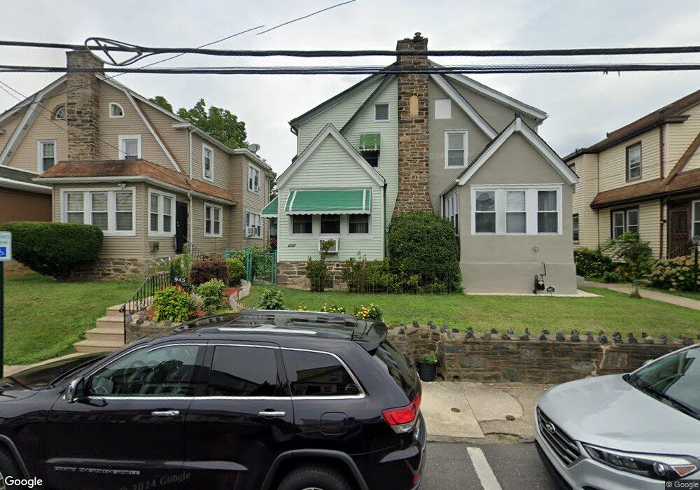
945 Bullock Ave Lansdowne, PA 19050
Estimated Value: $251,000 - $291,000
3
Beds
2
Baths
1,833
Sq Ft
$145/Sq Ft
Est. Value
About This Home
This home is located at 945 Bullock Ave, Lansdowne, PA 19050 and is currently estimated at $266,305, approximately $145 per square foot. 945 Bullock Ave is a home located in Delaware County with nearby schools including Evans Elementary School, Penn Wood Middle School, and Penn Wood High School - Cypress Street Campus.
Ownership History
Date
Name
Owned For
Owner Type
Purchase Details
Closed on
Jun 13, 2006
Sold by
Rodgers James B and Rodgers Sandra Venerse
Bought by
Rodgers James B and Rodgers Sandra V
Current Estimated Value
Home Financials for this Owner
Home Financials are based on the most recent Mortgage that was taken out on this home.
Original Mortgage
$108,800
Interest Rate
6.58%
Mortgage Type
Stand Alone Refi Refinance Of Original Loan
Create a Home Valuation Report for This Property
The Home Valuation Report is an in-depth analysis detailing your home's value as well as a comparison with similar homes in the area
Home Values in the Area
Average Home Value in this Area
Purchase History
| Date | Buyer | Sale Price | Title Company |
|---|---|---|---|
| Rodgers James B | -- | Lawyers Title Insurance Corp |
Source: Public Records
Mortgage History
| Date | Status | Borrower | Loan Amount |
|---|---|---|---|
| Closed | Rodgers James B | $108,800 |
Source: Public Records
Tax History Compared to Growth
Tax History
| Year | Tax Paid | Tax Assessment Tax Assessment Total Assessment is a certain percentage of the fair market value that is determined by local assessors to be the total taxable value of land and additions on the property. | Land | Improvement |
|---|---|---|---|---|
| 2025 | $5,593 | $130,970 | $32,570 | $98,400 |
| 2024 | $5,593 | $130,970 | $32,570 | $98,400 |
| 2023 | $5,079 | $130,970 | $32,570 | $98,400 |
| 2022 | $4,843 | $130,970 | $32,570 | $98,400 |
| 2021 | $7,324 | $130,970 | $32,570 | $98,400 |
| 2020 | $4,488 | $71,860 | $18,790 | $53,070 |
| 2019 | $4,409 | $71,860 | $18,790 | $53,070 |
| 2018 | $4,348 | $71,860 | $0 | $0 |
| 2017 | $4,256 | $71,860 | $0 | $0 |
| 2016 | $394 | $71,860 | $0 | $0 |
| 2015 | $394 | $71,860 | $0 | $0 |
| 2014 | $394 | $71,860 | $0 | $0 |
Source: Public Records
Map
Nearby Homes
- 932 Bullock Ave
- 939 Serrill Ave
- 921 Serrill Ave
- 908 Yeadon Ave
- 1021 Serrill Ave
- 932 Duncan Ave
- 923 Bell Ave
- 1049 Yeadon Ave
- 805 Yeadon Ave
- 800 Bullock Ave
- 1112 Serrill Ave
- 6718 Cobbs Creek Pkwy
- 740 Church Ln
- 6826 Cobbs Creek Pkwy
- 6535 Windsor St
- 729 Yeadon Ave
- 725 Yeadon Ave
- 6849 Chester Ave
- 6835 Chester Ave
- 6951 Chester Ave
- 943 Bullock Ave
- 947 Bullock Ave
- 941 Bullock Ave
- 949 Bullock Ave
- 951 Bullock Ave
- 939 Bullock Ave
- 937 Bullock Ave
- 942 Church Ln
- 953 Bullock Ave
- 936 Church Ln
- 935 Bullock Ave
- 955 Bullock Ave
- 948 Church Ln
- 933 Bullock Ave
- 944 Bullock Ave
- 942 Bullock Ave
- 946 Bullock Ave
- 940 Bullock Ave
- 948 Bullock Ave
- 957 Bullock Ave