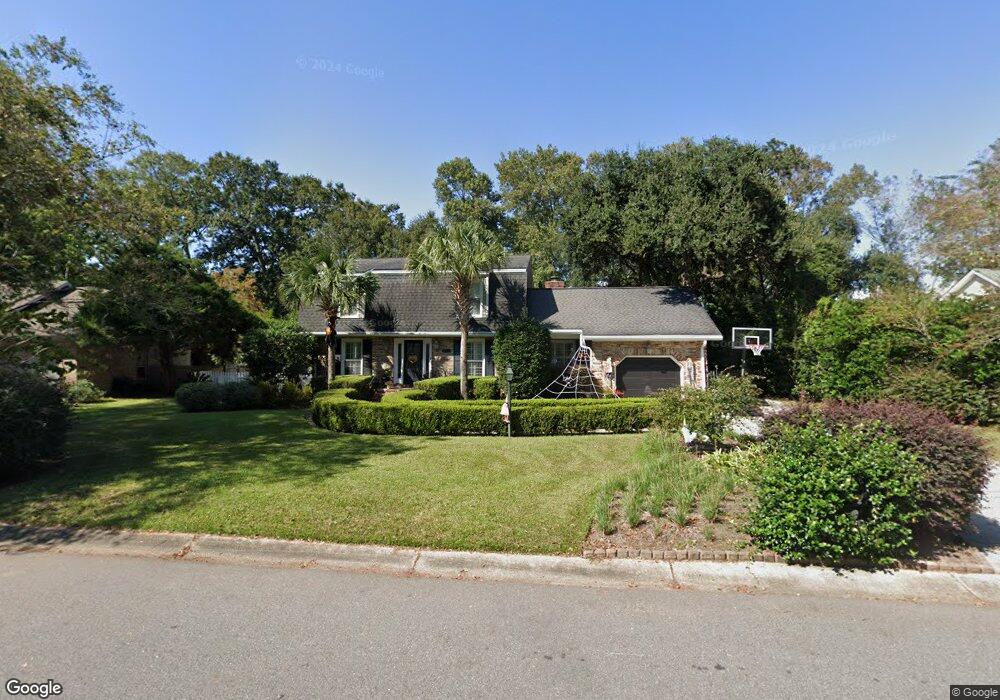
946 Anchor Rd Charleston, SC 29412
James Island NeighborhoodEstimated Value: $734,000 - $946,000
3
Beds
3
Baths
2,299
Sq Ft
$356/Sq Ft
Est. Value
About This Home
This home is located at 946 Anchor Rd, Charleston, SC 29412 and is currently estimated at $818,274, approximately $355 per square foot. 946 Anchor Rd is a home located in Charleston County with nearby schools including Stiles Point Elementary School, Camp Road Middle, and James Island Charter High School.
Ownership History
Date
Name
Owned For
Owner Type
Purchase Details
Closed on
Aug 29, 2013
Sold by
Smith Sharon Greer
Bought by
Smith Benjamin T and Smith Anna D
Current Estimated Value
Home Financials for this Owner
Home Financials are based on the most recent Mortgage that was taken out on this home.
Original Mortgage
$374,866
Outstanding Balance
$278,738
Interest Rate
4.31%
Mortgage Type
New Conventional
Estimated Equity
$539,536
Purchase Details
Closed on
Sep 13, 2010
Sold by
Estate Of John Douglas Smith and Smith Sharon Greer
Bought by
Smith Sharon Greer
Create a Home Valuation Report for This Property
The Home Valuation Report is an in-depth analysis detailing your home's value as well as a comparison with similar homes in the area
Home Values in the Area
Average Home Value in this Area
Purchase History
| Date | Buyer | Sale Price | Title Company |
|---|---|---|---|
| Smith Benjamin T | $388,000 | -- | |
| Smith Sharon Greer | -- | -- |
Source: Public Records
Mortgage History
| Date | Status | Borrower | Loan Amount |
|---|---|---|---|
| Open | Smith Benjamin T | $374,866 |
Source: Public Records
Tax History Compared to Growth
Tax History
| Year | Tax Paid | Tax Assessment Tax Assessment Total Assessment is a certain percentage of the fair market value that is determined by local assessors to be the total taxable value of land and additions on the property. | Land | Improvement |
|---|---|---|---|---|
| 2024 | $2,150 | $18,400 | $0 | $0 |
| 2023 | $2,150 | $18,400 | $0 | $0 |
| 2022 | $1,966 | $18,400 | $0 | $0 |
| 2021 | $2,108 | $18,400 | $0 | $0 |
| 2020 | $1,950 | $16,710 | $0 | $0 |
| 2019 | $1,888 | $15,520 | $0 | $0 |
| 2017 | $2,009 | $15,520 | $0 | $0 |
| 2016 | $1,923 | $15,520 | $0 | $0 |
| 2015 | $2,004 | $15,520 | $0 | $0 |
| 2014 | $1,900 | $0 | $0 | $0 |
| 2011 | -- | $0 | $0 | $0 |
Source: Public Records
Map
Nearby Homes
- 965 Mooring Dr
- 954 Harbortowne Rd
- 800 Heyward Cove Place
- 1013 Jamsie Cove Dr
- 865 Duvall St
- 804 Porcari St
- 816 Porcari St
- 939 Mikell Dr
- 969 Harbor View Rd
- 975 Harbor View Rd
- 1024 Greenhill Rd
- 1129 Quail Dr
- 1032 Greenhill Rd Unit A
- 777 Lake Frances Dr
- 1120 Seaside Ln
- 1149 Quail Dr
- 1102 Williams Rd
- 938 White Marlin Dr
- 825 Shutes Folly Dr
- 793 Shell Sand Rd
- 942 Anchor Rd
- 948 Anchor Rd
- 717 Lawton Harbor Dr
- 715 Lawton Harbor Dr
- 719 Lawton Harbor Dr
- 713 Lawton Harbor Dr
- 935 Anchor Rd
- 914 Regatta Rd
- 918 Regatta Rd
- 952 Anchor Rd
- 513 Cecilia Cove Dr
- 721 Lawton Harbor Dr
- 711 Lawton Harbor Dr
- 955 Anchor Rd
- 725 Lawton Harbor Dr
- 716 Lawton Harbor Dr
- 910 Regatta Rd
- 709 Lawton Harbor Dr
- 517 Cecilia Cove Dr
- 956 Mooring Dr