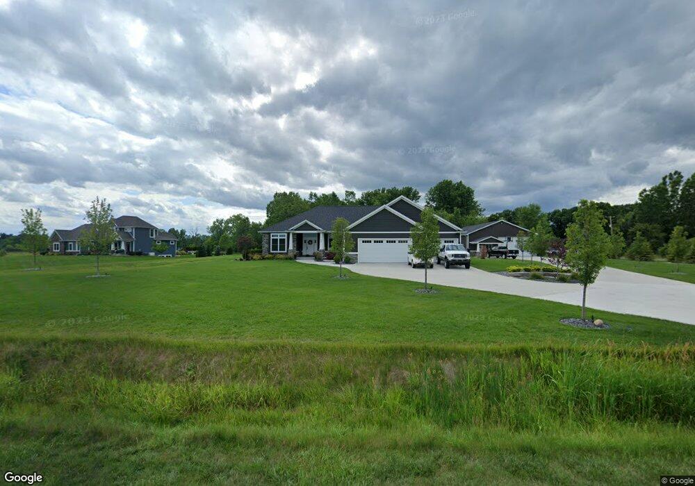
9469 Carter Rd Freeland, MI 48623
Estimated Value: $671,000 - $797,000
5
Beds
4
Baths
2,501
Sq Ft
$299/Sq Ft
Est. Value
About This Home
This home is located at 9469 Carter Rd, Freeland, MI 48623 and is currently estimated at $747,586, approximately $298 per square foot. 9469 Carter Rd is a home with nearby schools including Freeland Learning Center, Freeland Elementary School, and Freeland Middle/High School.
Ownership History
Date
Name
Owned For
Owner Type
Purchase Details
Closed on
Dec 30, 2020
Sold by
Lapierre Ken
Bought by
Lapierre Ken and Lapierre Lindsay
Current Estimated Value
Home Financials for this Owner
Home Financials are based on the most recent Mortgage that was taken out on this home.
Original Mortgage
$585,000
Outstanding Balance
$522,023
Interest Rate
2.7%
Mortgage Type
New Conventional
Estimated Equity
$225,563
Purchase Details
Closed on
Sep 13, 2019
Sold by
Cami Cumper Ret
Bought by
Lapierre Ken
Create a Home Valuation Report for This Property
The Home Valuation Report is an in-depth analysis detailing your home's value as well as a comparison with similar homes in the area
Home Values in the Area
Average Home Value in this Area
Purchase History
| Date | Buyer | Sale Price | Title Company |
|---|---|---|---|
| Lapierre Ken | -- | None Available | |
| Lapierre Ken | $48,000 | None Available |
Source: Public Records
Mortgage History
| Date | Status | Borrower | Loan Amount |
|---|---|---|---|
| Open | Lapierre Ken | $585,000 |
Source: Public Records
Tax History Compared to Growth
Tax History
| Year | Tax Paid | Tax Assessment Tax Assessment Total Assessment is a certain percentage of the fair market value that is determined by local assessors to be the total taxable value of land and additions on the property. | Land | Improvement |
|---|---|---|---|---|
| 2025 | $9,896 | $379,100 | $0 | $0 |
| 2024 | $2,960 | $347,300 | $0 | $0 |
| 2023 | $2,819 | $300,600 | $0 | $0 |
| 2022 | $8,111 | $271,500 | $0 | $0 |
| 2021 | $7,398 | $251,600 | $0 | $0 |
| 2020 | $771 | $19,600 | $0 | $0 |
| 2019 | $144 | $12,300 | $0 | $0 |
| 2018 | $32 | $11,200 | $0 | $0 |
| 2017 | $132 | $11,100 | $0 | $0 |
| 2016 | $131 | $0 | $0 | $0 |
Source: Public Records
Map
Nearby Homes
- 8981 Highland Dr
- 10585 Prairie View Ct
- 8884 Copper Ct
- 0 Foxtail Trail Unit 50182332
- 8657 Foxtail Trail
- 8630 Foxtail Trail
- 8483 N River Rock River Rock Unit 8487
- 5 Willow Point Dr
- 8599 Ashland Place
- 8535 Summer Ridge Dr
- 8442 Cottonwood Dr
- 10399 Webster Rd
- 10832 Carter Rd
- 9924 Garner Ln
- 8183 N River Rd
- 8421 Waxwing Dr
- 12422 Northway Pkwy
- 12449 Northway Pkwy
- 8611 Winding Brook Cir
- 10123 Hawk Dr
- 11096 Laduke Rd
- 9521 Carter Rd
- 11109 Laduke Rd
- 9599 Carter Rd
- 11133 Laduke Rd
- 11145 Laduke Rd
- 9480 Carter Rd
- 9433 Carter Rd
- 11177 Laduke Rd
- 9667 Carter Rd
- 11205 Laduke Rd
- 11234 Laduke Rd
- 11234 Laduke Rd
- 9689 Carter Rd
- 11261 Laduke Rd
- 9333 Carter Rd
- 11275 Laduke Rd
- 9785 Carter Rd
- 11344 Laduke Rd
- 11344 Laduke Rd