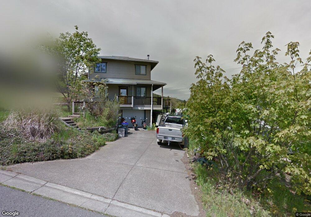
949 Cedar Way Ashland, OR 97520
North Ashland NeighborhoodEstimated Value: $477,000 - $568,000
3
Beds
2
Baths
1,258
Sq Ft
$424/Sq Ft
Est. Value
About This Home
This home is located at 949 Cedar Way, Ashland, OR 97520 and is currently estimated at $532,890, approximately $423 per square foot. 949 Cedar Way is a home located in Jackson County with nearby schools including Helman Elementary School, Ashland Middle School, and Ashland High School.
Ownership History
Date
Name
Owned For
Owner Type
Purchase Details
Closed on
Jan 22, 2016
Sold by
Rounds Susan Jay and Rounds Dylan E
Bought by
Rounds Dylan E and Rounds Susan Jay
Current Estimated Value
Home Financials for this Owner
Home Financials are based on the most recent Mortgage that was taken out on this home.
Original Mortgage
$190,000
Interest Rate
3.93%
Mortgage Type
New Conventional
Purchase Details
Closed on
Dec 22, 1999
Sold by
Jay Stephen H and Rounds Susan Jay
Bought by
Rounds Dylan E and Rounds Susan Jay
Create a Home Valuation Report for This Property
The Home Valuation Report is an in-depth analysis detailing your home's value as well as a comparison with similar homes in the area
Home Values in the Area
Average Home Value in this Area
Purchase History
| Date | Buyer | Sale Price | Title Company |
|---|---|---|---|
| Rounds Dylan E | -- | Ticor Title Company Of Or | |
| Rounds Dylan E | -- | -- |
Source: Public Records
Mortgage History
| Date | Status | Borrower | Loan Amount |
|---|---|---|---|
| Closed | Rounds Dylan E | $190,000 |
Source: Public Records
Tax History Compared to Growth
Tax History
| Year | Tax Paid | Tax Assessment Tax Assessment Total Assessment is a certain percentage of the fair market value that is determined by local assessors to be the total taxable value of land and additions on the property. | Land | Improvement |
|---|---|---|---|---|
| 2025 | $5,552 | $358,130 | $116,920 | $241,210 |
| 2024 | $5,552 | $347,700 | $113,510 | $234,190 |
| 2023 | $5,372 | $337,580 | $110,210 | $227,370 |
| 2022 | $5,199 | $337,580 | $110,210 | $227,370 |
| 2021 | $5,022 | $327,750 | $107,000 | $220,750 |
| 2020 | $4,881 | $318,210 | $103,890 | $214,320 |
| 2019 | $4,804 | $299,960 | $97,940 | $202,020 |
| 2018 | $4,539 | $291,230 | $95,090 | $196,140 |
| 2017 | $4,506 | $291,230 | $95,090 | $196,140 |
| 2016 | $4,388 | $274,520 | $89,630 | $184,890 |
| 2015 | $4,219 | $274,520 | $89,630 | $184,890 |
| 2014 | $4,049 | $258,770 | $84,480 | $174,290 |
Source: Public Records
Map
Nearby Homes
- 1179 N Main St
- 0 Schofield St Unit TL7200-TL7100
- 1501 Jackson Rd
- 720 Grover St
- 230 Grant St
- 242 Grant St
- 317 Maple St
- 472 Lindsay Ln
- 581 Scenic Dr Unit 9
- 347 Wimer St
- 495 Chestnut St Unit 6
- 495 Chestnut St Unit 19
- 662 Vansant St
- 311 Luna Vista St Unit 2
- 566 Coffee Ln
- 753 Wrights Creek Dr
- 364 Randy St
- 356 Randy St
- 360 Coventry Place
- 332 Randy St
- 945 Cedar Way
- 965 Cedar Way
- 1230 Ashland Mine Rd
- 950 Cedar Way
- 936 Cedar Way
- 1250 Ashland Mine Rd
- 1210 N Main St
- 211 Ashland Mine Rd
- 1210 Ashland Mine Rd
- 0 Ashland Mine Rd
- 1196 Ashland Mine Rd
- 1229 N Main St
- 206 Ashland Mine Rd
- 1221 N Main St
- 1260 Ashland Mine Rd
- 1190 N Main St
- 1213 N Main St
- 1180 Ashland Mine Rd
- 1249 Ashland Mine Rd