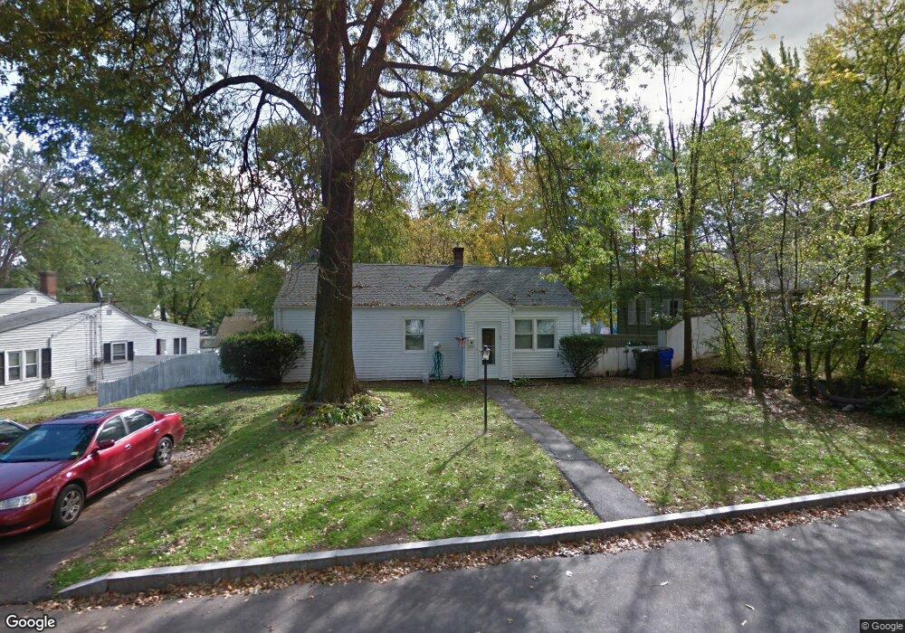
95 Cortland Cir West Hartford, CT 06110
Estimated Value: $280,000 - $371,000
4
Beds
1
Bath
960
Sq Ft
$335/Sq Ft
Est. Value
About This Home
This home is located at 95 Cortland Cir, West Hartford, CT 06110 and is currently estimated at $322,058, approximately $335 per square foot. 95 Cortland Cir is a home located in Hartford County with nearby schools including Webster Hill School, Sedgwick Middle School, and Conard High School.
Ownership History
Date
Name
Owned For
Owner Type
Purchase Details
Closed on
Feb 16, 2000
Sold by
Mundy Helen A
Bought by
Matos Migdalia
Current Estimated Value
Home Financials for this Owner
Home Financials are based on the most recent Mortgage that was taken out on this home.
Original Mortgage
$70,600
Outstanding Balance
$23,253
Interest Rate
8.11%
Estimated Equity
$298,805
Purchase Details
Closed on
Feb 5, 1991
Sold by
Auclair Flora
Bought by
Mundy Helen and Mundy Peter
Create a Home Valuation Report for This Property
The Home Valuation Report is an in-depth analysis detailing your home's value as well as a comparison with similar homes in the area
Home Values in the Area
Average Home Value in this Area
Purchase History
| Date | Buyer | Sale Price | Title Company |
|---|---|---|---|
| Matos Migdalia | $71,000 | -- | |
| Mundy Helen | $65,000 | -- |
Source: Public Records
Mortgage History
| Date | Status | Borrower | Loan Amount |
|---|---|---|---|
| Open | Mundy Helen | $70,600 |
Source: Public Records
Tax History Compared to Growth
Tax History
| Year | Tax Paid | Tax Assessment Tax Assessment Total Assessment is a certain percentage of the fair market value that is determined by local assessors to be the total taxable value of land and additions on the property. | Land | Improvement |
|---|---|---|---|---|
| 2025 | $5,332 | $119,070 | $46,340 | $72,730 |
| 2024 | $5,043 | $119,070 | $46,340 | $72,730 |
| 2023 | $4,872 | $119,070 | $46,340 | $72,730 |
| 2022 | $4,844 | $119,070 | $46,340 | $72,730 |
| 2021 | $4,671 | $110,110 | $42,140 | $67,970 |
| 2020 | $3,938 | $94,220 | $32,480 | $61,740 |
| 2019 | $3,938 | $94,220 | $32,480 | $61,740 |
| 2018 | $3,863 | $94,220 | $32,480 | $61,740 |
| 2017 | $3,867 | $94,220 | $32,480 | $61,740 |
| 2016 | $3,985 | $100,870 | $48,510 | $52,360 |
| 2015 | $3,864 | $100,870 | $48,510 | $52,360 |
| 2014 | $3,770 | $100,870 | $48,510 | $52,360 |
Source: Public Records
Map
Nearby Homes
- 39 Cortland St
- 67 Mayflower St
- 422 S Main St
- 1145 New Britain Ave
- 90 Park Place Cir Unit 90
- 49 Park Place Cir Unit 49
- 18 Federal St
- 16 School House Dr
- 62 Grove St
- 204 Trout Brook Dr
- 41 Page Ave
- 91 Shadow Ln Unit A2
- 83 Newington Rd
- 741 Quaker Ln S
- 24 Thorne Rd Unit 24
- 54 Jackson Ave
- 274 Newington Rd
- 63 Rumford St
- 32 Miles Standish Dr
- 21 Echo Ln
- 89 Cortland Cir
- 101 Cortland Cir
- 77 Vine Hill Rd
- 85 Vine Hill Rd
- 81 Cortland Cir
- 107 Cortland Cir
- 89 Vine Hill Rd
- 71 Vine Hill Rd
- 100 Cortland Cir
- 94 Cortland Cir
- 113 Cortland Cir
- 104 Cortland Cir
- 92 Cortland Cir
- 118 Cortland Cir
- 88 Cortland Cir
- 65 Vine Hill Rd
- 71 Cortland Cir
- 84 Cortland Cir
- 108 Cortland Cir
- 78 Cortland Cir