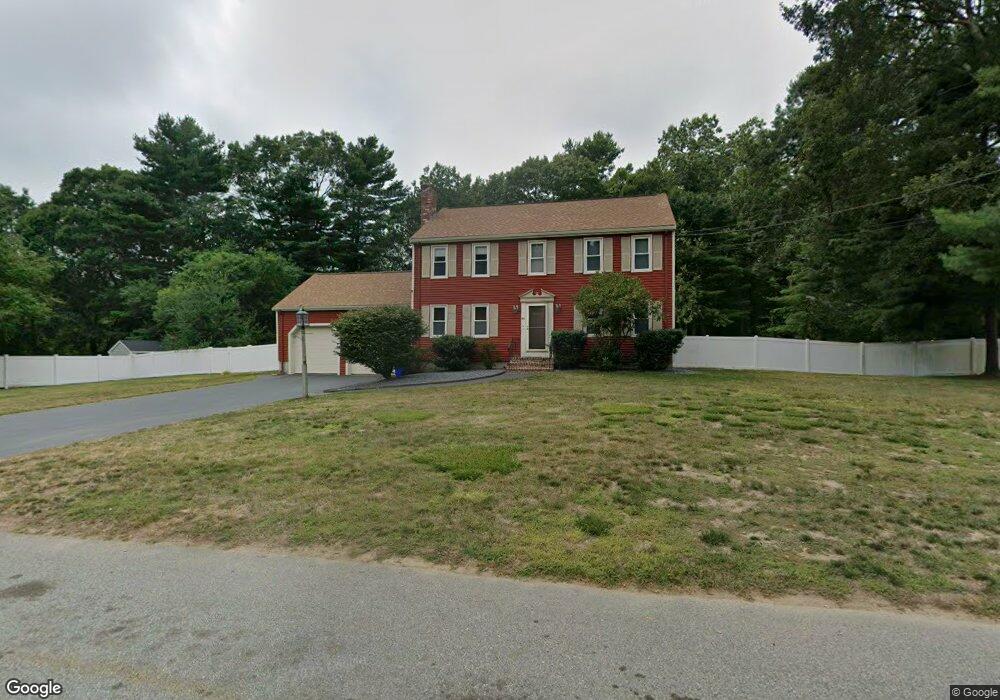
95 Duffy Dr Taunton, MA 02780
Weir Village NeighborhoodEstimated Value: $577,000 - $628,000
4
Beds
3
Baths
1,872
Sq Ft
$323/Sq Ft
Est. Value
About This Home
This home is located at 95 Duffy Dr, Taunton, MA 02780 and is currently estimated at $605,473, approximately $323 per square foot. 95 Duffy Dr is a home located in Bristol County with nearby schools including Elizabeth Pole School, Taunton High School, and John F. Parker Middle School.
Ownership History
Date
Name
Owned For
Owner Type
Purchase Details
Closed on
Dec 4, 2024
Sold by
Williams Donald
Bought by
Cla Williams Ft and Williams
Current Estimated Value
Purchase Details
Closed on
Oct 27, 2022
Sold by
Williams Kerry
Bought by
Williams Donald
Home Financials for this Owner
Home Financials are based on the most recent Mortgage that was taken out on this home.
Original Mortgage
$429,000
Interest Rate
6.02%
Mortgage Type
Purchase Money Mortgage
Purchase Details
Closed on
Oct 23, 2009
Sold by
Williams Donald
Bought by
Williams Donald and Williams Kerry
Home Financials for this Owner
Home Financials are based on the most recent Mortgage that was taken out on this home.
Original Mortgage
$204,000
Interest Rate
5.09%
Mortgage Type
Purchase Money Mortgage
Purchase Details
Closed on
Oct 29, 2004
Sold by
Rego Jan and Rego Karen M
Bought by
Williams Donald
Purchase Details
Closed on
Apr 27, 2001
Sold by
Neumeister Amy
Bought by
Rego Jan and Rego Karen M
Purchase Details
Closed on
Feb 20, 1990
Sold by
Adolph Coors Co
Bought by
Neumeister Anthony
Create a Home Valuation Report for This Property
The Home Valuation Report is an in-depth analysis detailing your home's value as well as a comparison with similar homes in the area
Home Values in the Area
Average Home Value in this Area
Purchase History
| Date | Buyer | Sale Price | Title Company |
|---|---|---|---|
| Cla Williams Ft | -- | None Available | |
| Cla Williams Ft | -- | None Available | |
| Williams Donald | $275,000 | None Available | |
| Williams Donald | -- | -- | |
| Williams Donald | -- | -- | |
| Williams Donald | $395,000 | -- | |
| Williams Donald | $395,000 | -- | |
| Rego Jan | $245,900 | -- | |
| Neumeister Anthony | $176,500 | -- | |
| Williams Donald | -- | -- | |
| Williams Donald | $395,000 | -- | |
| Rego Jan P | $245,900 | -- | |
| Neumeister Anthony K | $176,500 | -- |
Source: Public Records
Mortgage History
| Date | Status | Borrower | Loan Amount |
|---|---|---|---|
| Previous Owner | Williams Donald | $429,000 | |
| Previous Owner | Williams Donald | $204,000 |
Source: Public Records
Tax History
| Year | Tax Paid | Tax Assessment Tax Assessment Total Assessment is a certain percentage of the fair market value that is determined by local assessors to be the total taxable value of land and additions on the property. | Land | Improvement |
|---|---|---|---|---|
| 2025 | $5,757 | $526,200 | $143,000 | $383,200 |
| 2024 | $5,328 | $476,100 | $143,000 | $333,100 |
| 2023 | $5,380 | $446,500 | $149,500 | $297,000 |
| 2022 | $4,997 | $379,100 | $115,900 | $263,200 |
| 2021 | $5,004 | $352,400 | $105,400 | $247,000 |
| 2020 | $4,821 | $324,400 | $105,400 | $219,000 |
| 2019 | $4,938 | $313,300 | $108,300 | $205,000 |
| 2018 | $4,765 | $303,100 | $109,300 | $193,800 |
| 2017 | $4,565 | $290,600 | $103,800 | $186,800 |
| 2016 | $4,403 | $280,800 | $100,700 | $180,100 |
| 2015 | $4,281 | $285,200 | $103,000 | $182,200 |
| 2014 | $4,259 | $291,500 | $103,000 | $188,500 |
Source: Public Records
Map
Nearby Homes
- 5 Parcels Cape Highway Route 44
- 0 Cape Highway Route 44 Unit 73474847
- 24 Hunter St Unit A
- 0 S Main St Unit 73443212
- 115 Forge River Pkwy
- 152 Forgeriver
- 136 Dean St
- 136 Dean St Unit A&B
- 29 Johnson St Unit B
- 600 County St
- 38 Alicia Dr
- 0 Hart St Unit 73474079
- 22 Ingell St
- 1607 Carriage Ln Unit 1607
- 212 Carriage Ln Unit 212
- 1606 Carriage Ln Unit 1606
- 11 Dean St
- 800 County St Unit 23
- 3 Karena Dr Unit 4-21
- 816 County St Unit 11
Your Personal Tour Guide
Ask me questions while you tour the home.