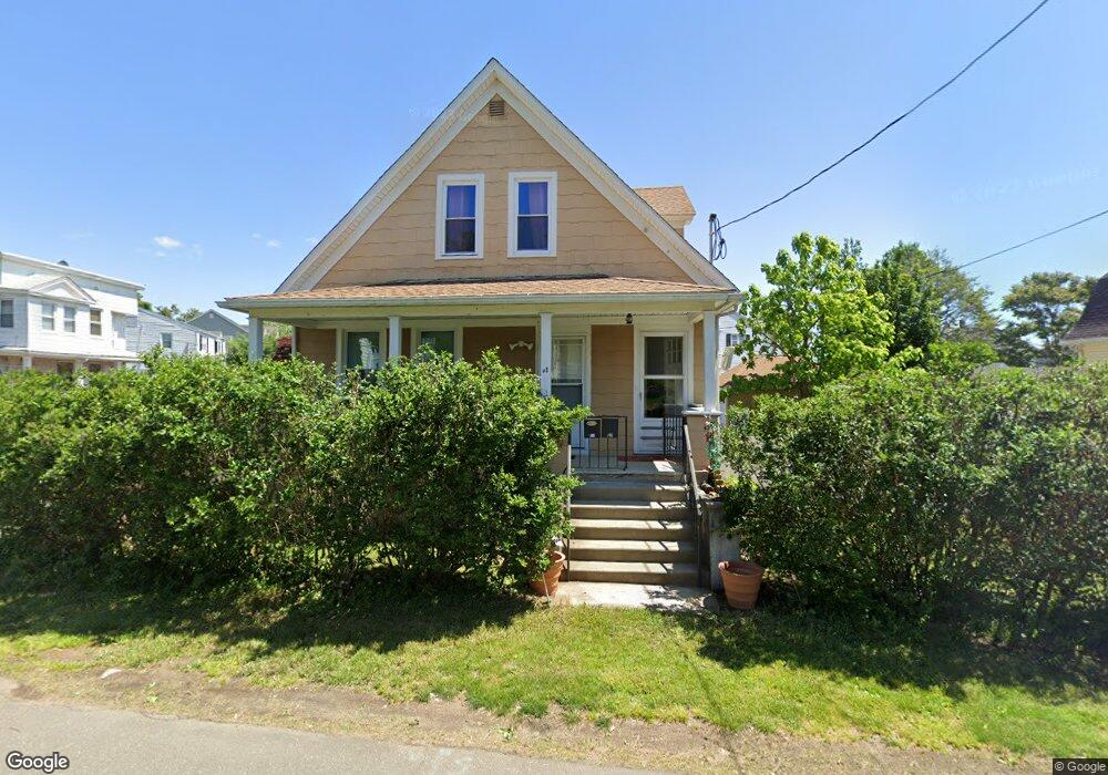
95 Holroyd St Bridgeport, CT 06606
Brooklawn-Saint Vincent NeighborhoodEstimated Value: $401,000 - $453,000
3
Beds
2
Baths
1,330
Sq Ft
$322/Sq Ft
Est. Value
About This Home
This home is located at 95 Holroyd St, Bridgeport, CT 06606 and is currently estimated at $427,971, approximately $321 per square foot. 95 Holroyd St is a home located in Fairfield County with nearby schools including Madison School, Central High School, and Catholic Academy of Bridgeport-St. Raphael Academy.
Ownership History
Date
Name
Owned For
Owner Type
Purchase Details
Closed on
Jun 18, 2018
Sold by
Wargo Rita
Bought by
Twigg Sonny
Current Estimated Value
Purchase Details
Closed on
Sep 19, 2017
Sold by
Ceresa Lucille
Bought by
Martin Lucy
Purchase Details
Closed on
Nov 29, 2016
Sold by
Marino Anthony
Bought by
Martin Lucy
Purchase Details
Closed on
Aug 16, 2016
Sold by
Mrino James
Bought by
Martin Lucy
Purchase Details
Closed on
Dec 30, 2015
Sold by
Fray Elizabeth
Bought by
Wargo Rita
Purchase Details
Closed on
Sep 30, 2010
Sold by
Monda Fannie
Bought by
Monda Concetta
Purchase Details
Closed on
Mar 30, 1967
Bought by
Wargo Rita
Create a Home Valuation Report for This Property
The Home Valuation Report is an in-depth analysis detailing your home's value as well as a comparison with similar homes in the area
Home Values in the Area
Average Home Value in this Area
Purchase History
| Date | Buyer | Sale Price | Title Company |
|---|---|---|---|
| Twigg Sonny | -- | -- | |
| Twigg Sonny | -- | -- | |
| Martin Lucy | -- | -- | |
| Martin Lucy | -- | -- | |
| Martin Lucy | -- | -- | |
| Martin Lucy | -- | -- | |
| Martin Lucy | -- | -- | |
| Martin Lucy | -- | -- | |
| Wargo Rita | -- | -- | |
| Wargo Rita | -- | -- | |
| Monda Concetta | -- | -- | |
| Monda Fannie | -- | -- | |
| Monda Fannie | -- | -- | |
| Wargo Rita | -- | -- |
Source: Public Records
Tax History Compared to Growth
Tax History
| Year | Tax Paid | Tax Assessment Tax Assessment Total Assessment is a certain percentage of the fair market value that is determined by local assessors to be the total taxable value of land and additions on the property. | Land | Improvement |
|---|---|---|---|---|
| 2025 | $6,681 | $153,760 | $77,650 | $76,110 |
| 2024 | $6,681 | $153,760 | $77,650 | $76,110 |
| 2023 | $6,681 | $153,760 | $77,650 | $76,110 |
| 2022 | $6,681 | $153,760 | $77,650 | $76,110 |
| 2021 | $6,681 | $153,760 | $77,650 | $76,110 |
| 2020 | $5,864 | $108,620 | $40,560 | $68,060 |
| 2019 | $5,864 | $108,620 | $40,560 | $68,060 |
| 2018 | $5,906 | $108,620 | $40,560 | $68,060 |
| 2017 | $5,906 | $108,620 | $40,560 | $68,060 |
| 2016 | $5,906 | $108,620 | $40,560 | $68,060 |
| 2015 | $5,709 | $135,280 | $49,100 | $86,180 |
| 2014 | $5,709 | $135,280 | $49,100 | $86,180 |
Source: Public Records
Map
Nearby Homes
- 241 Sampson St
- 11 Myron Ave
- 201 High Ridge Dr
- 150 Alexander Dr
- 125 Alexander Dr
- 119 Madison Terrace
- 203 Wayne St
- 508 Hawley Ave
- 252 Harlem Ave Unit B6
- 252 Harlem Ave Unit B5
- 105 Tremont Ave Unit E
- 105 Tremont Ave Unit B
- 106 Manhattan Ave Unit 108
- 123 Harlem Ave
- 724 Capitol Ave Unit 726
- 631 Fairview Ave
- 1275 Capitol Ave
- 390 Charles St Unit 106
- 2625 Park Ave Unit 12L
- 2625 Park Ave Unit 5N