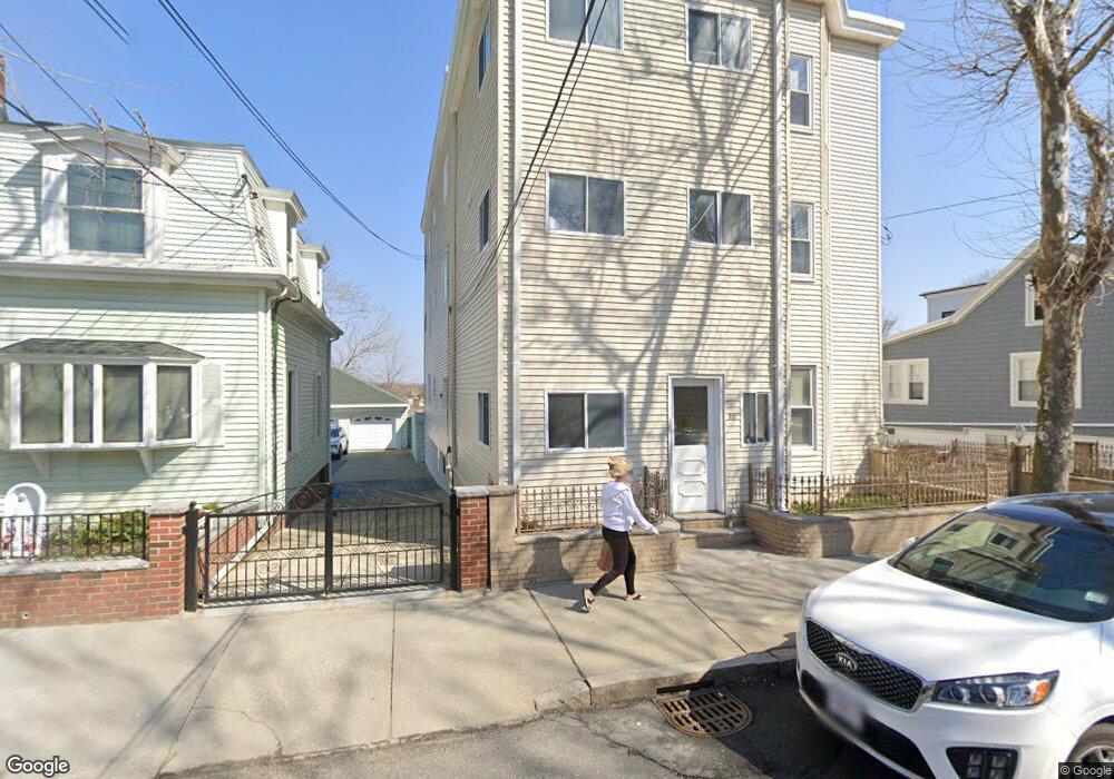
95 Jaques St Somerville, MA 02145
Ten Hills NeighborhoodEstimated Value: $1,381,000 - $1,985,000
9
Beds
3
Baths
4,317
Sq Ft
$390/Sq Ft
Est. Value
About This Home
This home is located at 95 Jaques St, Somerville, MA 02145 and is currently estimated at $1,682,667, approximately $389 per square foot. 95 Jaques St is a home located in Middlesex County with nearby schools including Somerville High School, Prospect Hill Academy Upper Elementary Campus, and Bright Future Educare Center.
Ownership History
Date
Name
Owned For
Owner Type
Purchase Details
Closed on
Jul 10, 1974
Bought by
Giordano Anthony R and Giordano Theresa
Current Estimated Value
Create a Home Valuation Report for This Property
The Home Valuation Report is an in-depth analysis detailing your home's value as well as a comparison with similar homes in the area
Home Values in the Area
Average Home Value in this Area
Purchase History
We collect this data history from publicly available records. To have your information removed, we recommend requesting removal directly through your county’s website.
| Date | Buyer | Sale Price | Title Company |
|---|---|---|---|
| Giordano Anthony R | $39,000 | -- |
Source: Public Records
Mortgage History
We collect this data history from publicly available records. To have your information removed, we recommend requesting removal directly through your county’s website.
| Date | Status | Borrower | Loan Amount |
|---|---|---|---|
| Open | Giordano Anthony R | $100,000 | |
| Closed | Giordano Anthony R | $55,000 | |
| Closed | Giordano Anthony R | $25,000 |
Source: Public Records
Tax History
| Year | Tax Paid | Tax Assessment Tax Assessment Total Assessment is a certain percentage of the fair market value that is determined by local assessors to be the total taxable value of land and additions on the property. | Land | Improvement |
|---|---|---|---|---|
| 2025 | $13,759 | $1,261,100 | $368,100 | $893,000 |
| 2024 | $12,867 | $1,223,100 | $368,100 | $855,000 |
| 2023 | $12,549 | $1,213,600 | $368,100 | $845,500 |
| 2022 | $12,015 | $1,180,300 | $350,600 | $829,700 |
| 2021 | $11,410 | $1,119,700 | $318,400 | $801,300 |
| 2020 | $11,174 | $1,107,400 | $306,100 | $801,300 |
| 2019 | $10,373 | $964,000 | $257,600 | $706,400 |
| 2018 | $8,599 | $760,300 | $234,200 | $526,100 |
| 2017 | $8,422 | $721,700 | $220,900 | $500,800 |
| 2016 | $7,705 | $614,900 | $179,400 | $435,500 |
| 2015 | $7,343 | $582,300 | $178,400 | $403,900 |
Source: Public Records
Map
Nearby Homes
- 13 Langmaid Ave Unit 1
- 13 Langmaid Ave Unit 3
- 60 Derby St Unit 4
- 33 Sewall St
- 115 Thurston St Unit I
- 8 Douglas Ave
- 41 Derby St Unit 2
- 7 Meacham St Unit 7
- 7 Meacham St
- 326 Broadway Unit 6
- 134 Heath St Unit 3
- 39 Ash Ave
- 102 Grant St Unit B
- 48 Ash Ave Unit B
- 2 Derby St
- 62 Governor Winthrop Rd Unit 1
- 7 Jaques St
- 93 Puritan Rd Unit 93
- 15 Kenneson Rd
- 34 Governor Winthrop Rd Unit 1
Your Personal Tour Guide
Ask me questions while you tour the home.