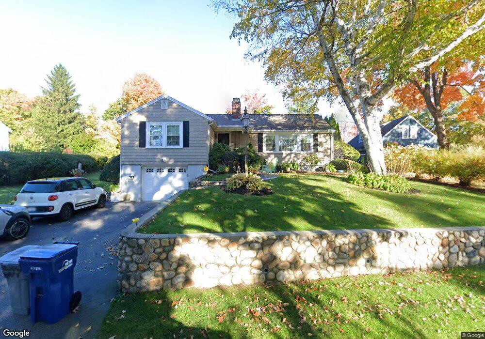
95 Macarthur Rd Stoneham, MA 02180
Bear Hill NeighborhoodEstimated Value: $751,000 - $1,060,000
3
Beds
2
Baths
1,917
Sq Ft
$447/Sq Ft
Est. Value
About This Home
This home is located at 95 Macarthur Rd, Stoneham, MA 02180 and is currently estimated at $857,820, approximately $447 per square foot. 95 Macarthur Rd is a home located in Middlesex County with nearby schools including Stoneham High School, St Joseph School, and St. Patrick Elementary School.
Ownership History
Date
Name
Owned For
Owner Type
Purchase Details
Closed on
Aug 18, 2005
Sold by
Zellen Marilyn J and Zellen Richard C
Bought by
Lograsso Filomena and Lograsso Salvatore
Current Estimated Value
Home Financials for this Owner
Home Financials are based on the most recent Mortgage that was taken out on this home.
Original Mortgage
$429,600
Interest Rate
5.66%
Mortgage Type
Purchase Money Mortgage
Purchase Details
Closed on
Dec 18, 2001
Sold by
Peterson-Perry Rita M
Bought by
Zellen Richard C and Zellen Marilyn J
Create a Home Valuation Report for This Property
The Home Valuation Report is an in-depth analysis detailing your home's value as well as a comparison with similar homes in the area
Home Values in the Area
Average Home Value in this Area
Purchase History
| Date | Buyer | Sale Price | Title Company |
|---|---|---|---|
| Lograsso Filomena | $537,000 | -- | |
| Zellen Richard C | $383,500 | -- |
Source: Public Records
Mortgage History
| Date | Status | Borrower | Loan Amount |
|---|---|---|---|
| Open | Zellen Richard C | $400,550 | |
| Closed | Lograsso Filomena | $429,600 |
Source: Public Records
Tax History
| Year | Tax Paid | Tax Assessment Tax Assessment Total Assessment is a certain percentage of the fair market value that is determined by local assessors to be the total taxable value of land and additions on the property. | Land | Improvement |
|---|---|---|---|---|
| 2025 | $7,029 | $687,100 | $401,000 | $286,100 |
| 2024 | $6,762 | $638,500 | $371,000 | $267,500 |
| 2023 | $6,620 | $596,400 | $341,000 | $255,400 |
| 2022 | $5,845 | $561,500 | $321,000 | $240,500 |
| 2021 | $49 | $528,800 | $301,000 | $227,800 |
| 2020 | $5,733 | $531,300 | $301,000 | $230,300 |
| 2019 | $5,713 | $509,200 | $271,000 | $238,200 |
| 2018 | $6,682 | $475,300 | $251,000 | $224,300 |
| 2017 | $49 | $439,900 | $241,000 | $198,900 |
| 2016 | $5,384 | $423,900 | $241,000 | $182,900 |
| 2015 | $5,299 | $408,900 | $241,000 | $167,900 |
| 2014 | $5,002 | $370,800 | $221,000 | $149,800 |
Source: Public Records
Map
Nearby Homes
- 62 High St Unit Lot 8
- 62 High St Unit 4
- 62 High St Unit Lot 5
- 62 High St Unit Lot 12
- 66 Main St Unit 15A
- 64 Main St Unit 24B
- 12 Isola Ln
- 95 Prospect St
- 8 Steele St
- 98 Main St Unit 2
- 68 Main St Unit 21C
- 55 Bartley St
- 3 Valley Rd
- 39 Cedar St
- 159 Main St Unit 27C
- 159 Main St Unit 39A
- 248 Albion St Unit 231
- 248 Albion St Unit 321
- 58 Washington St
- 11 Valdora Dr
- 93 Macarthur Rd
- 93 Macarthur Rd
- 2 Spalding Rd
- 97 Macarthur Rd
- 91 Macarthur Rd
- 18 Greenview Rd
- 96 Macarthur Rd
- 19 Greenview Rd
- 32 Winship Dr
- 99 Macarthur Rd
- 34 Winship Dr Unit 1
- 87 Macarthur Rd
- 17 Greenview Rd
- 98 Macarthur Rd
- 36 Winship Dr
- 101 Macarthur Rd
- 86 Macarthur Rd
- 42 Lawndale Rd
- 15 Greenview Rd
- 14 Greenview Rd
Your Personal Tour Guide
Ask me questions while you tour the home.