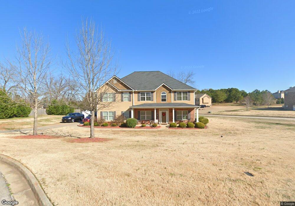
95 Muirfield Dr Covington, GA 30016
Estimated Value: $420,352 - $466,000
4
Beds
4
Baths
3,200
Sq Ft
$138/Sq Ft
Est. Value
About This Home
This home is located at 95 Muirfield Dr, Covington, GA 30016 and is currently estimated at $442,838, approximately $138 per square foot. 95 Muirfield Dr is a home located in Newton County with nearby schools including Livingston Elementary School, Liberty Middle School, and Alcovy High School.
Ownership History
Date
Name
Owned For
Owner Type
Purchase Details
Closed on
Dec 21, 2012
Sold by
H Roberts Inc
Bought by
Tolbert Robert A
Current Estimated Value
Home Financials for this Owner
Home Financials are based on the most recent Mortgage that was taken out on this home.
Original Mortgage
$200,000
Outstanding Balance
$137,445
Interest Rate
3.35%
Mortgage Type
VA
Estimated Equity
$305,393
Create a Home Valuation Report for This Property
The Home Valuation Report is an in-depth analysis detailing your home's value as well as a comparison with similar homes in the area
Home Values in the Area
Average Home Value in this Area
Purchase History
| Date | Buyer | Sale Price | Title Company |
|---|---|---|---|
| Tolbert Robert A | $200,000 | -- |
Source: Public Records
Mortgage History
| Date | Status | Borrower | Loan Amount |
|---|---|---|---|
| Open | Tolbert Robert A | $200,000 |
Source: Public Records
Tax History
| Year | Tax Paid | Tax Assessment Tax Assessment Total Assessment is a certain percentage of the fair market value that is determined by local assessors to be the total taxable value of land and additions on the property. | Land | Improvement |
|---|---|---|---|---|
| 2025 | $4,077 | $168,880 | $25,200 | $143,680 |
| 2024 | $3,966 | $158,080 | $25,200 | $132,880 |
| 2023 | $3,859 | $143,920 | $9,600 | $134,320 |
| 2022 | $2,542 | $95,360 | $9,600 | $85,760 |
| 2021 | $3,049 | $102,480 | $9,600 | $92,880 |
| 2020 | $3,148 | $95,840 | $9,600 | $86,240 |
| 2019 | $3,018 | $90,640 | $9,600 | $81,040 |
| 2018 | $2,924 | $87,360 | $11,200 | $76,160 |
| 2017 | $3,088 | $92,120 | $11,200 | $80,920 |
| 2016 | $2,714 | $81,240 | $5,600 | $75,640 |
| 2015 | $2,761 | $82,640 | $5,600 | $77,040 |
| 2014 | $2,368 | $73,040 | $0 | $0 |
Source: Public Records
Map
Nearby Homes
- 60 Muirfield Dr
- 50 Glen Echo Dr
- 15 Glen Echo Dr
- 66 Ellis Trail
- 75 Cannonade Ct
- 335 Glen Echo Dr
- 179 Ellis Trail
- 230 Belmont Trail
- 40 Belmont Cir Unit 2
- 25 Castlehill Ct
- 70 Blackberry Ln
- 230 Laurel Way
- 100 Willow Shoals Dr
- 395 Willow Shoals Dr
- 125 Willow Shoals Dr
- 10 Oaklake Ct
- 20 Crooked Creek Way
- 195 Cedar Rd
- 585 Cowan Rd
- 295 Long Creek Dr
- 85 Muirfield Dr
- 70 Muirfield Dr
- 75 Muirfield Dr
- 105 Muirfield Dr
- 90 Muirfield Dr
- 10 Paladin Dr Unit 65
- 10 Paladin Dr
- 3823 Highway 81 S Unit 39
- 3823 Highway 81 S
- 3821 Highway 81 S
- 65 Muirfield Dr
- 65 Muirfield Dr
- 65 Muirfield Dr Unit 65
- 20 Paladin Dr Unit 66
- 20 Paladin Dr
- 120 Muirfield Dr
- 115 Tanglewood Dr
- 55 Muirfield Dr
- 75 Tanglewood Dr
- 135 Tanglewood Dr
Your Personal Tour Guide
Ask me questions while you tour the home.