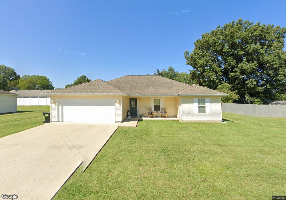
95 Pin Oak Ln Harrisburg, IL 62946
Estimated Value: $185,689 - $209,000
3
Beds
2
Baths
1,508
Sq Ft
$130/Sq Ft
Est. Value
About This Home
This home is located at 95 Pin Oak Ln, Harrisburg, IL 62946 and is currently estimated at $196,172, approximately $130 per square foot. 95 Pin Oak Ln is a home located in Saline County with nearby schools including East Side Intermediate School, Harrisburg Middle School, and Harrisburg High School.
Ownership History
Date
Name
Owned For
Owner Type
Purchase Details
Closed on
Aug 7, 2019
Sold by
Clarida Lindsey Kay and Witherspoon James Emmerson
Bought by
Brigham Timothy and Brigham Andrea
Current Estimated Value
Home Financials for this Owner
Home Financials are based on the most recent Mortgage that was taken out on this home.
Original Mortgage
$133,000
Outstanding Balance
$117,291
Interest Rate
4.25%
Mortgage Type
New Conventional
Estimated Equity
$78,881
Purchase Details
Closed on
Jul 15, 2008
Sold by
Budget Builders Wholesale Lumber Co
Bought by
Clarida Lindsey K
Home Financials for this Owner
Home Financials are based on the most recent Mortgage that was taken out on this home.
Original Mortgage
$102,300
Interest Rate
6.5%
Mortgage Type
New Conventional
Create a Home Valuation Report for This Property
The Home Valuation Report is an in-depth analysis detailing your home's value as well as a comparison with similar homes in the area
Home Values in the Area
Average Home Value in this Area
Purchase History
| Date | Buyer | Sale Price | Title Company |
|---|---|---|---|
| Brigham Timothy | $140,000 | Attorney | |
| Clarida Lindsey K | $126,000 | None Available |
Source: Public Records
Mortgage History
| Date | Status | Borrower | Loan Amount |
|---|---|---|---|
| Open | Brigham Timothy | $133,000 | |
| Previous Owner | Clarida Lindsey K | $102,300 |
Source: Public Records
Tax History Compared to Growth
Tax History
| Year | Tax Paid | Tax Assessment Tax Assessment Total Assessment is a certain percentage of the fair market value that is determined by local assessors to be the total taxable value of land and additions on the property. | Land | Improvement |
|---|---|---|---|---|
| 2024 | -- | $57,549 | $6,157 | $51,392 |
| 2023 | -- | $48,779 | $5,219 | $43,560 |
| 2022 | -- | $45,983 | $4,920 | $41,063 |
| 2021 | $0 | $47,404 | $5,072 | $42,332 |
| 2020 | $0 | $45,983 | $4,920 | $41,063 |
| 2019 | $2,293 | $40,935 | $4,920 | $36,015 |
| 2018 | $3,803 | $40,935 | $4,920 | $36,015 |
| 2017 | $3,745 | $40,935 | $4,920 | $36,015 |
| 2016 | $37 | $40,935 | $4,920 | $36,015 |
| 2015 | -- | $40,935 | $4,920 | $36,015 |
| 2014 | $3,520 | $40,935 | $4,920 | $36,015 |
| 2013 | $3,520 | $40,935 | $4,920 | $36,015 |
| 2012 | $3,520 | $41,750 | $5,735 | $36,015 |
Source: Public Records
Map
Nearby Homes
- 1116 S Holland St
- 405 S Shaw St
- 205 S Shaw St
- 827 W Raymond St
- 614 W College St
- 1006 S Land St
- 1116 S Land St
- 615 Liberty Rd
- 1101 S Mckinley St
- 500 W Sloan St
- 734 S Mckinley St
- 618 S Mckinley St
- 520 S Mckinley St
- 1523 S Mckinley St
- 0000 S Commercial St
- 504 W South St
- 885 Liberty Rd
- 517 W Barnett St
- 201 W Ogara St
- 1111 S Roosevelt St