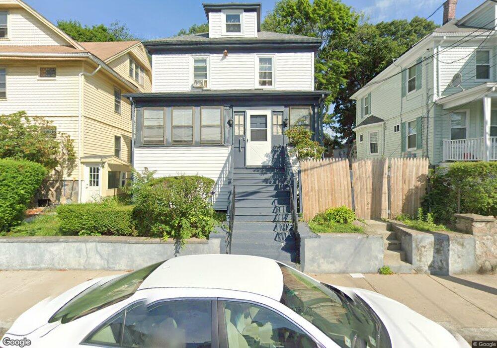
95 Rockdale St Mattapan, MA 02126
Southern Mattapan NeighborhoodEstimated Value: $619,000 - $652,698
3
Beds
2
Baths
1,688
Sq Ft
$375/Sq Ft
Est. Value
About This Home
This home is located at 95 Rockdale St, Mattapan, MA 02126 and is currently estimated at $633,425, approximately $375 per square foot. 95 Rockdale St is a home located in Suffolk County with nearby schools including KIPP Academy Boston Charter School, Boston Preparatory Charter Public School, and Berea Seventh-day Adventist Academy.
Ownership History
Date
Name
Owned For
Owner Type
Purchase Details
Closed on
Oct 9, 2015
Sold by
Harleston Mary M and Smith Teena
Bought by
Harleston Mary M
Current Estimated Value
Purchase Details
Closed on
May 14, 2015
Sold by
Harleston Mary M
Bought by
Harleston Mary M and Smith Teena
Create a Home Valuation Report for This Property
The Home Valuation Report is an in-depth analysis detailing your home's value as well as a comparison with similar homes in the area
Home Values in the Area
Average Home Value in this Area
Purchase History
| Date | Buyer | Sale Price | Title Company |
|---|---|---|---|
| Harleston Mary M | -- | -- | |
| Harleston Mary M | -- | -- |
Source: Public Records
Tax History Compared to Growth
Tax History
| Year | Tax Paid | Tax Assessment Tax Assessment Total Assessment is a certain percentage of the fair market value that is determined by local assessors to be the total taxable value of land and additions on the property. | Land | Improvement |
|---|---|---|---|---|
| 2025 | $6,080 | $525,000 | $183,100 | $341,900 |
| 2024 | $5,360 | $491,700 | $187,300 | $304,400 |
| 2023 | $5,028 | $468,200 | $178,400 | $289,800 |
| 2022 | $4,718 | $433,600 | $165,200 | $268,400 |
| 2021 | $4,406 | $412,900 | $157,300 | $255,600 |
| 2020 | $4,164 | $394,300 | $162,200 | $232,100 |
| 2019 | $3,495 | $331,600 | $121,600 | $210,000 |
| 2018 | $3,248 | $309,900 | $121,600 | $188,300 |
| 2017 | $3,011 | $284,300 | $121,600 | $162,700 |
| 2016 | $2,842 | $258,400 | $121,600 | $136,800 |
| 2015 | $2,252 | $186,000 | $94,200 | $91,800 |
| 2014 | $2,385 | $189,600 | $95,900 | $93,700 |
Source: Public Records
Map
Nearby Homes
- 48-50 Rockdale St
- 90 Hollingsworth St
- 645 River St
- 25 Malta St
- 23 Caton St
- 25 Alpine St Unit 7
- 16 Blue Hill Ave
- 20 Massasoit St
- 84 Blue Hills Pkwy
- 770 Cummins Hwy Unit 1
- 770 Cummins Hwy Unit 22
- 112 Brush Hill Rd
- 96 Brook Rd
- 10 Brockton St
- 42 Osceola St
- 128 Blue Hills Pkwy
- 7 Winborough St
- 839-843 Cummins Hwy
- 95 Woodhaven St
- 27 Hawthorn Rd
- 91 Rockdale St
- 99 Rockdale St
- 99 Rockdale St Unit 1
- 99 Rockdale St Unit 2
- 103 Rockdale St
- 89 Rockdale St
- 92 Rosewood St
- 96 Rosewood St
- 88 Rosewood St
- 85 Rockdale St
- 100 Rosewood St
- 84 Rosewood St
- 98 Rockdale St
- 109 Rockdale St
- 109 Rockdale St Unit 2
- 94 Rockdale St
- 104 Rosewood St
- 92 Rockdale St
- 100 Rockdale St
- 82 Rosewood St