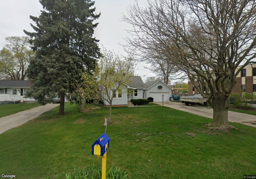
950 Englewood Ave Norton Shores, MI 49441
Estimated Value: $201,000 - $219,000
2
Beds
1
Bath
894
Sq Ft
$234/Sq Ft
Est. Value
About This Home
This home is located at 950 Englewood Ave, Norton Shores, MI 49441 and is currently estimated at $209,197, approximately $234 per square foot. 950 Englewood Ave is a home located in Muskegon County with nearby schools including Mona Shores High School, Edgewood Elementary Academy, and Dr. Martin Luther King Academy.
Ownership History
Date
Name
Owned For
Owner Type
Purchase Details
Closed on
Aug 12, 2015
Sold by
Hines Jerry D
Bought by
Robertson Barbara Ann and Hines Jerry D
Current Estimated Value
Purchase Details
Closed on
Nov 8, 2005
Sold by
Hines Jerry D and Robertson Barbara Ann
Bought by
Hines Jerry D
Home Financials for this Owner
Home Financials are based on the most recent Mortgage that was taken out on this home.
Original Mortgage
$70,000
Interest Rate
8.55%
Mortgage Type
New Conventional
Create a Home Valuation Report for This Property
The Home Valuation Report is an in-depth analysis detailing your home's value as well as a comparison with similar homes in the area
Home Values in the Area
Average Home Value in this Area
Purchase History
| Date | Buyer | Sale Price | Title Company |
|---|---|---|---|
| Robertson Barbara Ann | -- | None Available | |
| Hines Jerry D | -- | Fatic |
Source: Public Records
Mortgage History
| Date | Status | Borrower | Loan Amount |
|---|---|---|---|
| Closed | Hines Jerry D | $70,000 |
Source: Public Records
Tax History Compared to Growth
Tax History
| Year | Tax Paid | Tax Assessment Tax Assessment Total Assessment is a certain percentage of the fair market value that is determined by local assessors to be the total taxable value of land and additions on the property. | Land | Improvement |
|---|---|---|---|---|
| 2025 | $1,616 | $84,900 | $0 | $0 |
| 2024 | $1,267 | $78,700 | $0 | $0 |
| 2023 | $1,210 | $71,000 | $0 | $0 |
| 2022 | $1,475 | $61,100 | $0 | $0 |
| 2021 | $1,418 | $51,900 | $0 | $0 |
| 2020 | $1,402 | $48,300 | $0 | $0 |
| 2019 | $1,376 | $43,600 | $0 | $0 |
| 2018 | $1,344 | $40,200 | $0 | $0 |
| 2017 | $1,313 | $39,900 | $0 | $0 |
| 2016 | $1,016 | $37,300 | $0 | $0 |
| 2015 | -- | $34,900 | $0 | $0 |
| 2014 | $1,220 | $33,800 | $0 | $0 |
| 2013 | -- | $32,400 | $0 | $0 |
Source: Public Records
Map
Nearby Homes
- 1068 Englewood Ave
- 1130 Englewood Ave
- 945 Petrie Ave
- 4468 Spruce Ct
- 1067 Aspen Dr
- 4476 Cedar Ln Unit 54
- 4102 Highgate Rd
- V/L 4535 Thompson Rd
- 1065 Wilson Ct
- 1201 Shettler Rd
- 4535 Thompson Rd
- 4638 Lauren Dr
- 4060 Buck St
- 3920 Highgate Rd
- 1454 Airport Rd
- 4085 Quainton Rd
- 4677 Harvey St
- 4875 Paul Ct
- V/L E Ellis Rd
- 3835 Molly Blvd
- 944 Englewood Ave
- 4265 Grand Haven Rd
- 4265 Grand Haven Rd Unit 200
- 4265 Grand Haven Rd Unit 100
- 4265 Grand Haven Rd
- 4215 Grand Haven Rd
- 953 Airport Rd
- 939 Airport Rd
- 927 Airport Rd
- 948 Airport Rd
- 909 Airport Rd
- 938 Airport Rd
- 926 Airport Rd
- 32 Englewood Ave
- 31 Englewood Ave
- 1036 Englewood Ave
- 885 Airport Rd
- 914 Airport Rd
- 902 Airport Rd
- 1048 Englewood Ave