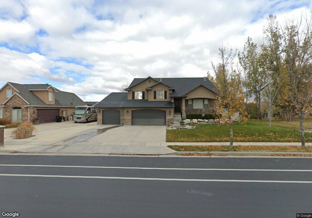
950 W 1600 N Woods Cross, UT 84087
Estimated Value: $815,000 - $884,000
5
Beds
3
Baths
3,778
Sq Ft
$223/Sq Ft
Est. Value
About This Home
This home is located at 950 W 1600 N, Woods Cross, UT 84087 and is currently estimated at $842,444, approximately $222 per square foot. 950 W 1600 N is a home located in Davis County with nearby schools including West Bountiful Elementary School, Bountiful Junior High School, and Viewmont High School.
Ownership History
Date
Name
Owned For
Owner Type
Purchase Details
Closed on
Jul 2, 2020
Sold by
Murri Jason Rex and Murri Alexis B
Bought by
Murri Jason
Current Estimated Value
Home Financials for this Owner
Home Financials are based on the most recent Mortgage that was taken out on this home.
Original Mortgage
$415,750
Outstanding Balance
$367,837
Interest Rate
3.1%
Mortgage Type
New Conventional
Estimated Equity
$474,607
Purchase Details
Closed on
Sep 14, 2018
Sold by
Hansen Michael D and Hansen Amy L
Bought by
Murri Jason Rex and Murri Alexis B
Home Financials for this Owner
Home Financials are based on the most recent Mortgage that was taken out on this home.
Original Mortgage
$416,415
Interest Rate
4.6%
Mortgage Type
New Conventional
Purchase Details
Closed on
Sep 1, 2017
Sold by
Hansen Micahel D
Bought by
Hansen Michael D and Hansen Amy L
Purchase Details
Closed on
Feb 24, 2006
Sold by
Beehive Building Inc
Bought by
Hansen Michael D and Hansen Amy L
Home Financials for this Owner
Home Financials are based on the most recent Mortgage that was taken out on this home.
Original Mortgage
$235,000
Interest Rate
6.04%
Mortgage Type
Construction
Purchase Details
Closed on
Dec 30, 2004
Sold by
Centennial Bank Inc
Bought by
Beehive Building Inc
Home Financials for this Owner
Home Financials are based on the most recent Mortgage that was taken out on this home.
Original Mortgage
$630,000
Interest Rate
5.8%
Mortgage Type
Seller Take Back
Purchase Details
Closed on
Aug 18, 2004
Sold by
Thurgood Development Corp
Bought by
Centennial Bank Inc
Purchase Details
Closed on
Sep 10, 2003
Sold by
Willow Bend Inc
Bought by
Thurgood Development Corp
Home Financials for this Owner
Home Financials are based on the most recent Mortgage that was taken out on this home.
Original Mortgage
$800,000
Interest Rate
6.3%
Mortgage Type
Purchase Money Mortgage
Create a Home Valuation Report for This Property
The Home Valuation Report is an in-depth analysis detailing your home's value as well as a comparison with similar homes in the area
Home Values in the Area
Average Home Value in this Area
Purchase History
| Date | Buyer | Sale Price | Title Company |
|---|---|---|---|
| Murri Jason | -- | Aspen Title Insurance | |
| Murri Jason Rex | -- | Backman Title Services | |
| Hansen Michael D | -- | Backman Title | |
| Hansen Michael D | -- | -- | |
| Hansen Michael D | -- | Aspen Title Insurance Agency | |
| Beehive Building Inc | -- | Aspen Title Insurance Agency | |
| Centennial Bank Inc | $600,000 | Bonneville Title Company Inc | |
| Thurgood Development Corp | -- | Founders Title Co |
Source: Public Records
Mortgage History
| Date | Status | Borrower | Loan Amount |
|---|---|---|---|
| Open | Murri Jason | $415,750 | |
| Closed | Murri Jason Rex | $416,415 | |
| Previous Owner | Hansen Michael D | $235,000 | |
| Previous Owner | Beehive Building Inc | $630,000 | |
| Previous Owner | Thurgood Development Corp | $800,000 |
Source: Public Records
Tax History Compared to Growth
Tax History
| Year | Tax Paid | Tax Assessment Tax Assessment Total Assessment is a certain percentage of the fair market value that is determined by local assessors to be the total taxable value of land and additions on the property. | Land | Improvement |
|---|---|---|---|---|
| 2025 | $4,621 | $401,500 | $108,237 | $293,263 |
| 2024 | $4,365 | $387,200 | $88,903 | $298,297 |
| 2023 | $4,198 | $681,000 | $211,154 | $469,846 |
| 2022 | $4,332 | $393,800 | $100,547 | $293,253 |
| 2021 | $3,908 | $531,000 | $134,296 | $396,704 |
| 2020 | $3,696 | $472,000 | $125,662 | $346,338 |
| 2019 | $3,488 | $474,000 | $127,637 | $346,363 |
| 2018 | $3,296 | $441,000 | $129,136 | $311,864 |
| 2016 | $2,822 | $203,830 | $32,621 | $171,209 |
| 2015 | $2,914 | $199,815 | $32,621 | $167,194 |
| 2014 | $2,782 | $195,013 | $32,621 | $162,392 |
| 2013 | -- | $147,296 | $40,751 | $106,545 |
Source: Public Records
Map
Nearby Homes
- 1084 W Audrey Ln Unit 20
- 1084 W Audrey Ln
- 988 W 1950 N Unit 134
- 825 W 1320 N
- 2257 N 830 W
- 637 W 1600 N
- 668 W 2300 N
- Lincoln Farmhouse Plan at Belmont Farms
- Belmont Traditional Plan at Belmont Farms
- Hampton Traditional Plan at Belmont Farms
- 548 S 675 W
- 280 N 1100 W
- 366 W 1000 N
- 790 N 500 W
- 239 Lyman Ln
- 767 W 220 N
- 234 Leah Cir
- 324 S 600 W
- 235 W 1400 N
- Carson Plan at Amberly Place
- 950 W 1600 N Unit 601
- 964 W 1600 N
- 964 W 1600 N Unit 602
- 936 W 1600 N
- 662 W Pages Ln
- 961 Meadowland Cir
- 955 Meadowland Cir
- 980 W 1600 N
- 980 W 1600 N Unit 603
- 965 W 1600 N
- 981 Meadowland Cir
- 981 Meadowland Cir Unit 606
- 935 W 1600 N
- 983 W 1600 N
- 935 Pages Ln
- 994 Pages Ln
- 954 Meadowland Cir
- 994 W 1600 N
- 994 W 1600 N Unit 604
- 993 Meadowland Cir