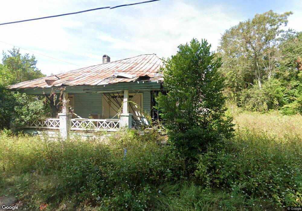
951 G St Waycross, GA 31501
Estimated Value: $53,000 - $125,000
--
Bed
1
Bath
1,486
Sq Ft
$63/Sq Ft
Est. Value
About This Home
This home is located at 951 G St, Waycross, GA 31501 and is currently estimated at $94,333, approximately $63 per square foot. 951 G St is a home located in Ware County with nearby schools including Wacona Elementary School, Ware County Middle School, and Ware County High School.
Ownership History
Date
Name
Owned For
Owner Type
Purchase Details
Closed on
Nov 6, 2014
Sold by
Graham Blondell E
Bought by
Jordan Joseph
Current Estimated Value
Purchase Details
Closed on
May 10, 1999
Sold by
Branch Cheryl
Bought by
Goodwin Myrtice and Goodwin Blondell
Purchase Details
Closed on
Apr 24, 1999
Sold by
Martin Rosalyn
Bought by
Goodwin Myrtice and Goodwin Blondell
Purchase Details
Closed on
Apr 20, 1999
Sold by
Perkins Elaine R
Bought by
Goodwin Myrtice and Goodwin Blondell
Purchase Details
Closed on
Apr 16, 1999
Sold by
Ray E C
Bought by
Goodwin Myrtice and Goodwin Blondell
Purchase Details
Closed on
Apr 13, 1999
Sold by
Branch Robert
Bought by
Goodwin Myrtice and Goodwin Blondell
Create a Home Valuation Report for This Property
The Home Valuation Report is an in-depth analysis detailing your home's value as well as a comparison with similar homes in the area
Home Values in the Area
Average Home Value in this Area
Purchase History
| Date | Buyer | Sale Price | Title Company |
|---|---|---|---|
| Jordan Joseph | $3,000 | -- | |
| Goodwin Myrtice | -- | -- | |
| Goodwin Myrtice | -- | -- | |
| Goodwin Myrtice | -- | -- | |
| Goodwin Myrtice | -- | -- | |
| Goodwin Myrtice | -- | -- |
Source: Public Records
Tax History Compared to Growth
Tax History
| Year | Tax Paid | Tax Assessment Tax Assessment Total Assessment is a certain percentage of the fair market value that is determined by local assessors to be the total taxable value of land and additions on the property. | Land | Improvement |
|---|---|---|---|---|
| 2024 | $97 | $2,880 | $2,880 | $0 |
| 2023 | $99 | $1,046 | $1,046 | $0 |
| 2022 | $42 | $1,046 | $1,046 | $0 |
| 2021 | $212 | $4,902 | $1,046 | $3,856 |
| 2020 | $210 | $4,828 | $1,046 | $3,782 |
| 2019 | $212 | $4,790 | $1,046 | $3,744 |
| 2018 | $212 | $4,751 | $1,046 | $3,705 |
| 2017 | $207 | $4,751 | $1,046 | $3,705 |
| 2016 | $207 | $4,751 | $1,046 | $3,705 |
| 2015 | $53 | $4,750 | $1,046 | $3,705 |
| 2014 | $248 | $5,653 | $1,046 | $4,608 |
| 2013 | -- | $5,653 | $1,045 | $4,607 |
Source: Public Records
Map
Nearby Homes
- 812 Effie St
- 1027 Robert St
- 629 Remshart St
- 1006 Roosevelt St
- 601 N Nicholls St
- 516 Folks St
- 1003 Carswell Ave
- 605 Walker St
- 511 Riverside Dr
- 310 Butler St
- 506 McDonald St
- 505 N Nicholls St
- 503 N Nicholls St
- 00 Roosevelt St
- 1219 Clough St
- 301 Riverside Dr
- 1504 Habersham Dr
- 1601 Genoa St
- 1405 Grove Ave
- 803 Elizabeth St
- 955 G St
- 910 Arnold McKinney Dr
- 828 Arnold McKinney Dr
- 901 Jones St
- 903 Jones St
- 905 Jones St
- 901 Arnold McKinney Dr
- 905 Arnold McKinney Dr
- 826 Arnold McKinney Dr
- 907 Arnold McKinney Dr
- 827 Arnold McKinney Dr
- 819 Jones St
- 916 Arnold McKinney Dr
- 893 G St
- 946 G St
- 822 Arnold McKinney Dr
- 904 Jones St
- 902 Jones St
- 821 Arnold McKinney Dr
- 813 Jones St