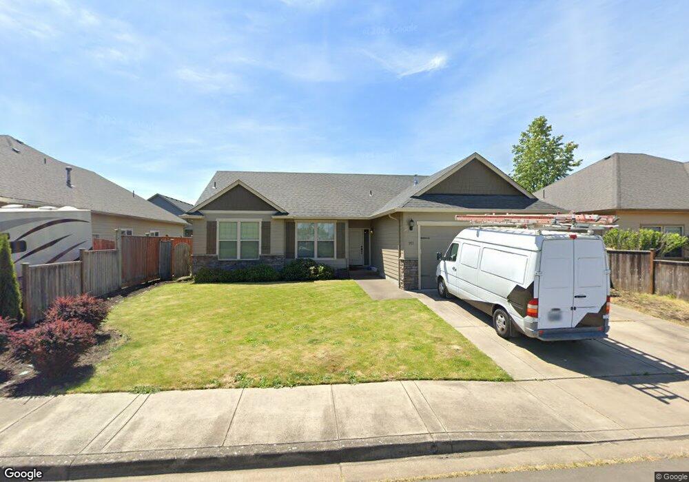
951 Ladd Ave Junction City, OR 97448
Estimated Value: $441,160 - $490,000
3
Beds
2
Baths
1,520
Sq Ft
$309/Sq Ft
Est. Value
About This Home
This home is located at 951 Ladd Ave, Junction City, OR 97448 and is currently estimated at $469,790, approximately $309 per square foot. 951 Ladd Ave is a home located in Lane County with nearby schools including Junction City High School.
Ownership History
Date
Name
Owned For
Owner Type
Purchase Details
Closed on
Jul 5, 2012
Sold by
Bruce Wiechert Custom Homes Inc
Bought by
Wiechert Bruce and Wiechert Joanne
Current Estimated Value
Purchase Details
Closed on
Nov 5, 2009
Sold by
Murry Ross
Bought by
Bruce Wiechert Custom Homes Inc
Purchase Details
Closed on
Apr 16, 2007
Sold by
Murry Ross
Bought by
Coast Range Construction Inc
Home Financials for this Owner
Home Financials are based on the most recent Mortgage that was taken out on this home.
Original Mortgage
$732,600
Interest Rate
6.1%
Mortgage Type
Purchase Money Mortgage
Create a Home Valuation Report for This Property
The Home Valuation Report is an in-depth analysis detailing your home's value as well as a comparison with similar homes in the area
Home Values in the Area
Average Home Value in this Area
Purchase History
| Date | Buyer | Sale Price | Title Company |
|---|---|---|---|
| Wiechert Bruce | -- | Cascade Title Company | |
| Bruce Wiechert Custom Homes Inc | $627,000 | Fidelity National Title Insu | |
| Coast Range Construction Inc | $840,000 | Western Title & Escrow Compa |
Source: Public Records
Mortgage History
| Date | Status | Borrower | Loan Amount |
|---|---|---|---|
| Previous Owner | Coast Range Construction Inc | $732,600 |
Source: Public Records
Tax History
| Year | Tax Paid | Tax Assessment Tax Assessment Total Assessment is a certain percentage of the fair market value that is determined by local assessors to be the total taxable value of land and additions on the property. | Land | Improvement |
|---|---|---|---|---|
| 2025 | $4,082 | $238,128 | -- | -- |
| 2024 | $3,940 | $231,193 | -- | -- |
| 2023 | $3,940 | $224,460 | $0 | $0 |
| 2022 | $3,676 | $217,923 | $0 | $0 |
| 2021 | $3,602 | $211,576 | $0 | $0 |
| 2020 | $3,487 | $205,414 | $0 | $0 |
| 2019 | $3,364 | $199,432 | $0 | $0 |
| 2018 | $3,267 | $187,984 | $0 | $0 |
| 2017 | $3,153 | $187,984 | $0 | $0 |
| 2016 | $3,065 | $182,509 | $0 | $0 |
| 2015 | $2,714 | $177,193 | $0 | $0 |
| 2014 | $2,723 | $172,032 | $0 | $0 |
Source: Public Records
Map
Nearby Homes
- 928 SW Coral St
- 93982 Prairie (Off Street) Rd
- 310 Pitney Ln Unit 25
- 310 Pitney Ln Unit 51
- 310 Pitney Ln Unit 40
- 1085 W 1st Ave Unit 8
- 1085 W 1st Ave Unit R
- 1085 W 1st Ave Unit E
- 115 Saxon Place
- 645 Juniper St
- 1225 W 10th Ave Unit 26
- 1225 W 10th Ave Unit 50
- 1225 W 10th Ave
- 371 E 2nd Ave
- 145 River Rd
- 970 W 10th Ave
- 920 W 10th Ave
- 1036 Oak St
- 1011 Rose St
- 145 River Rd
Your Personal Tour Guide
Ask me questions while you tour the home.