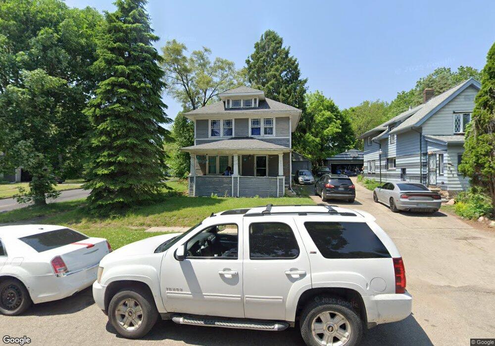
951 Perry St Flint, MI 48504
Mott Park NeighborhoodEstimated Value: $58,000 - $77,801
3
Beds
1
Bath
1,284
Sq Ft
$56/Sq Ft
Est. Value
About This Home
This home is located at 951 Perry St, Flint, MI 48504 and is currently estimated at $71,700, approximately $55 per square foot. 951 Perry St is a home located in Genesee County with nearby schools including Durant-Tuuri-Mott Elementary School, St John Vianney Catholic School, and St. Paul Lutheran School.
Ownership History
Date
Name
Owned For
Owner Type
Purchase Details
Closed on
Jan 20, 2021
Sold by
Genesee County Land Bank Authority
Bought by
Urbina Jose and Masias-De-Olivares Ana Maria
Current Estimated Value
Purchase Details
Closed on
Sep 1, 2015
Sold by
The Genesee County Land Bank Authority
Bought by
Urbina Jose and Masias De Olivares Ana Maria
Purchase Details
Closed on
Dec 22, 2014
Sold by
Genesee County Treasurer
Bought by
Genesee County Land Bank
Purchase Details
Closed on
Jul 21, 2006
Sold by
Bank One Na
Bought by
Front Door Financial
Purchase Details
Closed on
Mar 1, 2006
Sold by
Bradshaw Wayne R and Bradshaw Doris S
Bought by
Bank One Na
Create a Home Valuation Report for This Property
The Home Valuation Report is an in-depth analysis detailing your home's value as well as a comparison with similar homes in the area
Home Values in the Area
Average Home Value in this Area
Purchase History
| Date | Buyer | Sale Price | Title Company |
|---|---|---|---|
| Urbina Jose | $7,000 | None Listed On Document | |
| Urbina Jose | $7,000 | None Available | |
| Genesee County Land Bank | -- | None Available | |
| Front Door Financial | -- | Cislo Title Co | |
| Bank One Na | $44,000 | None Available |
Source: Public Records
Tax History
| Year | Tax Paid | Tax Assessment Tax Assessment Total Assessment is a certain percentage of the fair market value that is determined by local assessors to be the total taxable value of land and additions on the property. | Land | Improvement |
|---|---|---|---|---|
| 2025 | $2,409 | $32,200 | $0 | $0 |
| 2024 | $2,204 | $30,000 | $0 | $0 |
| 2023 | -- | $0 | $0 | $0 |
| 2022 | $0 | $0 | $0 | $0 |
| 2021 | $1,041 | $18,500 | $0 | $0 |
| 2020 | $958 | $15,800 | $0 | $0 |
| 2019 | $2,027 | $12,800 | $0 | $0 |
| 2018 | $1,067 | $11,500 | $0 | $0 |
| 2017 | $1,891 | $0 | $0 | $0 |
| 2016 | $896 | $0 | $0 | $0 |
| 2015 | -- | $0 | $0 | $0 |
| 2014 | -- | $0 | $0 | $0 |
| 2012 | -- | $13,400 | $0 | $0 |
Source: Public Records
Map
Nearby Homes
- 913 Perry St
- 2023 Cadillac St
- 1900 Cadillac St
- 1016 Dupont St
- 2026 Monteith St
- 751 Dupont St
- 971 N Chevrolet Ave
- 1025 Frost St
- 1717 Wolcott St
- 825 Frank St
- 2410 Sloan St
- 2008 University Ave
- 1409 Prospect St
- 2513 Tiffin St
- 2001 Mackin Rd
- 2602 Sloan St
- 2540 Altoona St
- 2547 Altoona St
- 314 Sheffield Ave
- 320 Sheffield Ave
- 955 Perry St
- 2006 Cadillac St
- 959 Perry St
- 2001 Cadillac St
- 2010 Cadillac St
- 2011 Cadillac St
- 963 Perry St
- 2007 Cadillac St
- 2014 Cadillac St
- 1916 Cadillac St
- 967 Perry St
- 2018 Cadillac St
- 1909 Bagley St
- 954 Perry St
- 909 Perry St
- 1913 Bagley St
- 916 Perry St
- 1917 Bagley St
- 958 Perry St
- 2015 Cadillac St
Your Personal Tour Guide
Ask me questions while you tour the home.