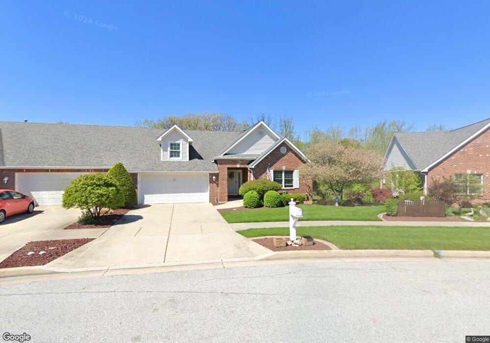
952 Ryan Ct Crown Point, IN 46307
Estimated Value: $417,000 - $466,000
4
Beds
3
Baths
3,126
Sq Ft
$141/Sq Ft
Est. Value
About This Home
This home is located at 952 Ryan Ct, Crown Point, IN 46307 and is currently estimated at $440,494, approximately $140 per square foot. 952 Ryan Ct is a home located in Lake County with nearby schools including Lake Street Elementary School, Robert Taft Middle School, and Crown Point High School.
Ownership History
Date
Name
Owned For
Owner Type
Purchase Details
Closed on
Jul 8, 2015
Sold by
Nutt Joyce M and Granger Elizabeth A
Bought by
Taylor Living Trust
Current Estimated Value
Purchase Details
Closed on
Oct 30, 2012
Sold by
Nutt Joyce M and Granger Elizabeth A
Bought by
Nutt Joyce M and Nutt Elizabeth A
Create a Home Valuation Report for This Property
The Home Valuation Report is an in-depth analysis detailing your home's value as well as a comparison with similar homes in the area
Home Values in the Area
Average Home Value in this Area
Purchase History
| Date | Buyer | Sale Price | Title Company |
|---|---|---|---|
| Taylor Living Trust | -- | Meridian Title Corp | |
| Nutt Joyce M | -- | None Available |
Source: Public Records
Tax History
| Year | Tax Paid | Tax Assessment Tax Assessment Total Assessment is a certain percentage of the fair market value that is determined by local assessors to be the total taxable value of land and additions on the property. | Land | Improvement |
|---|---|---|---|---|
| 2025 | $3,774 | $395,300 | $83,700 | $311,600 |
| 2024 | $9,265 | $385,400 | $83,700 | $301,700 |
| 2023 | $3,729 | $337,100 | $69,700 | $267,400 |
| 2022 | $3,615 | $324,000 | $69,700 | $254,300 |
| 2021 | $3,459 | $310,300 | $68,500 | $241,800 |
| 2020 | $3,366 | $302,100 | $68,500 | $233,600 |
| 2019 | $3,479 | $308,100 | $68,500 | $239,600 |
| 2018 | $4,426 | $314,100 | $68,500 | $245,600 |
| 2017 | $4,497 | $315,100 | $68,500 | $246,600 |
| 2016 | $4,637 | $318,700 | $68,500 | $250,200 |
| 2014 | $4,438 | $319,800 | $68,500 | $251,300 |
| 2013 | $4,379 | $312,900 | $68,500 | $244,400 |
Source: Public Records
Map
Nearby Homes
- 914 Lillian Russell Ct
- 964 Ryan Ct
- 804 Shannon Dr
- 1089 George Ade Ct
- 3709 W 121st Ave
- 1144 Mary Ellen Dr
- 815 Hayfield Dr
- 1140 Hyde Park
- 745 Huey Dr
- 12109 White Oak Dr
- 817 Mary Ellen Dr
- 778 Ronny Ct
- 3516 W 123rd Place
- 12275 S Williams Ct
- 1002 Gordon Ct
- 460 O'Hagan Dr
- 780 Williams Ct
- 11606 Westvalley Dr
- 437 Fairview Ave
- 1575 S Feather Rock Dr
- 950 Ryan Ct
- 954 Ryan Ct
- 948 Ryan Ct
- 946 Ryan Ct
- 958 Ryan Ct
- 912 Lillian Russell Ct
- 912 Lillian Russell Ct
- 944 Ryan Ct
- 916 Lillian Russell Ct
- 1055 Mary Ellen Dr
- 918 Lillian Russell Ct
- 942 Ryan Ct
- 920 Lillian Russell Ct
- 1045 Mary Ellen Dr
- 962 Ryan Ct
- 1059 Mary Ellen Dr
- Lot 344 Lillian Russell Ct
- Lot 342 Lillian Russell Ct
- Lot 354 Lillian Russell Ct
- Lot 349 Lillian Russell Ct
Your Personal Tour Guide
Ask me questions while you tour the home.