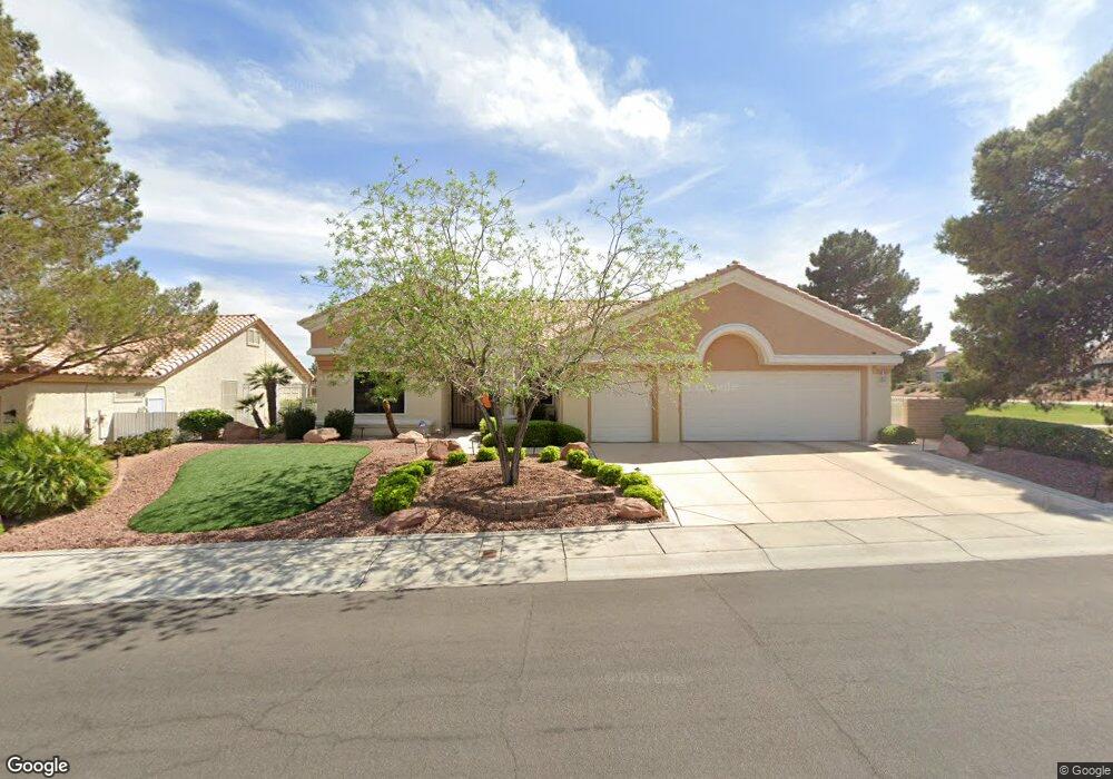
9521 Villa Ridge Dr Unit 26 Las Vegas, NV 89134
Sun City Summerlin NeighborhoodEstimated Value: $861,305 - $1,407,000
2
Beds
3
Baths
2,577
Sq Ft
$410/Sq Ft
Est. Value
About This Home
This home is located at 9521 Villa Ridge Dr Unit 26, Las Vegas, NV 89134 and is currently estimated at $1,056,826, approximately $410 per square foot. 9521 Villa Ridge Dr Unit 26 is a home located in Clark County with nearby schools including William Lummis Elementary School, Ernest Becker Middle School, and Palo Verde High School.
Ownership History
Date
Name
Owned For
Owner Type
Purchase Details
Closed on
Nov 29, 2010
Sold by
Day Donald Yates and Day Jane E
Bought by
Andrzejewski Edward F and Andrzejewski Patricia A
Current Estimated Value
Home Financials for this Owner
Home Financials are based on the most recent Mortgage that was taken out on this home.
Original Mortgage
$230,000
Outstanding Balance
$150,246
Interest Rate
4%
Mortgage Type
New Conventional
Estimated Equity
$906,580
Purchase Details
Closed on
Aug 26, 2003
Sold by
Day Donald Yates and Day Jane E
Bought by
Day Donald Yates and Day Jane E
Home Financials for this Owner
Home Financials are based on the most recent Mortgage that was taken out on this home.
Original Mortgage
$271,800
Interest Rate
6.06%
Mortgage Type
Unknown
Purchase Details
Closed on
Jun 5, 2001
Sold by
Day Donald Yates and Day Jane E
Bought by
Day Donald Yates and Day Jane E
Purchase Details
Closed on
Jan 22, 2001
Sold by
Kinnison Jon W and Kinnison Miriam
Bought by
Day Donald Yates and Day Jane E
Home Financials for this Owner
Home Financials are based on the most recent Mortgage that was taken out on this home.
Original Mortgage
$275,000
Interest Rate
7.06%
Purchase Details
Closed on
Feb 17, 1999
Sold by
Hayes James M and Hayes Sharon M
Bought by
Kinnison Jon W and Kinnison Miriam
Purchase Details
Closed on
Apr 21, 1998
Sold by
Hayes Sharon M
Bought by
Hayes James M and Hayes Sharon M
Home Financials for this Owner
Home Financials are based on the most recent Mortgage that was taken out on this home.
Original Mortgage
$227,150
Interest Rate
7.15%
Purchase Details
Closed on
Jul 5, 1995
Sold by
Hayes Sharon M
Bought by
Hayes Sharon
Purchase Details
Closed on
Oct 18, 1994
Sold by
Del Webb Communities Inc
Bought by
Hayes Sharon M
Purchase Details
Closed on
Oct 12, 1994
Sold by
Hayes James M
Bought by
Hayes Sharon M
Create a Home Valuation Report for This Property
The Home Valuation Report is an in-depth analysis detailing your home's value as well as a comparison with similar homes in the area
Home Values in the Area
Average Home Value in this Area
Purchase History
| Date | Buyer | Sale Price | Title Company |
|---|---|---|---|
| Andrzejewski Edward F | $460,000 | Equity Title Of Nevada | |
| Day Donald Yates | -- | Old Republic Title Co Of Ne | |
| Day Donald Yates | -- | Old Republic Title Co Of Ne | |
| Day Donald Yates | -- | -- | |
| Day Donald Yates | $469,500 | Old Republic Title Company | |
| Kinnison Jon W | $426,500 | Old Republic Title Company | |
| Hayes James M | -- | Land Title | |
| Hayes Sharon M | -- | Land Title | |
| Hayes Sharon | -- | -- | |
| Hayes Sharon M | $344,000 | First American Title Company | |
| Hayes Sharon M | -- | First American Title Company |
Source: Public Records
Mortgage History
| Date | Status | Borrower | Loan Amount |
|---|---|---|---|
| Open | Andrzejewski Edward F | $230,000 | |
| Previous Owner | Day Donald Yates | $271,800 | |
| Previous Owner | Day Donald Yates | $275,000 | |
| Previous Owner | Hayes Sharon M | $227,150 |
Source: Public Records
Tax History Compared to Growth
Tax History
| Year | Tax Paid | Tax Assessment Tax Assessment Total Assessment is a certain percentage of the fair market value that is determined by local assessors to be the total taxable value of land and additions on the property. | Land | Improvement |
|---|---|---|---|---|
| 2025 | $4,768 | $175,873 | $69,650 | $106,223 |
| 2024 | $4,630 | $175,873 | $69,650 | $106,223 |
| 2023 | $4,630 | $162,175 | $61,250 | $100,925 |
| 2022 | $4,495 | $140,373 | $47,950 | $92,423 |
| 2021 | $4,364 | $134,571 | $46,200 | $88,371 |
| 2020 | $4,234 | $134,057 | $46,200 | $87,857 |
| 2019 | $4,111 | $128,487 | $41,650 | $86,837 |
| 2018 | $3,991 | $121,749 | $37,800 | $83,949 |
| 2017 | $3,961 | $119,967 | $35,700 | $84,267 |
| 2016 | $3,784 | $114,476 | $30,100 | $84,376 |
| 2015 | $3,777 | $110,719 | $27,300 | $83,419 |
| 2014 | $3,660 | $107,551 | $25,550 | $82,001 |
Source: Public Records
Map
Nearby Homes
- 3109 Bangor Ct
- 2937 Billy Casper Dr
- 3109 Hawksdale Dr Unit 27
- 3012 Hawksdale Dr
- 3016 Lotus Hill Dr
- 3004 Lotus Hill Dr
- 3228 Mystic Ridge Ct
- 3104 Hayden Ct
- 3215 Mystic Ridge Ct
- 3112 Haddon Dr
- 9445 January Dr
- 2925 Lotus Hill Dr
- 2916 Hawksdale Dr
- 9352 Villa Ridge Dr
- 9428 January Dr
- 3016 High Range Dr
- 2837 Billy Casper Dr
- 9412 Mount Cherie Ave Unit 102
- 9333 Mount Cherie Ave Unit 102
- 9401 Mount Cash Ave Unit 103
- 9517 Villa Ridge Dr
- 3101 Bangor Ct
- 9513 Villa Ridge Dr
- 9509 Villa Ridge Dr
- 3105 Bangor Ct
- 3036 Hawksdale Dr
- 3100 Bangor Ct
- 3032 Hawksdale Dr
- 3100 Hawksdale Dr Unit 27
- 9505 Villa Ridge Dr
- 3028 Hawksdale Dr
- 3104 Hawksdale Dr
- 3104 Bangor Ct
- 3101 Gundy Ct
- 3024 Hawksdale Dr
- 9501 Villa Ridge Dr
- 3108 Bangor Ct
- 3108 Hawksdale Dr
- 3105 Gundy Ct
- 3037 Hawksdale Dr