Estimated Value: $800,000 - $881,000
4
Beds
2
Baths
1,652
Sq Ft
$499/Sq Ft
Est. Value
About This Home
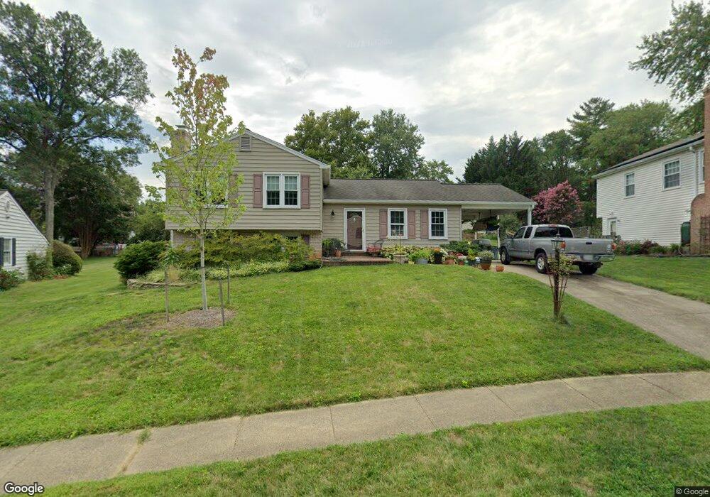
This home is located at 9527 Barnstable Ct, Burke, VA 22015 and is currently estimated at $825,009, approximately $499 per square foot. 9527 Barnstable Ct is a home located in Fairfax County with nearby schools including Kings Park Elementary School, Kings Glen Elementary School, and Lake Braddock Secondary School.
Ownership History
Date
Name
Owned For
Owner Type
Purchase Details
Closed on
Sep 7, 1999
Sold by
Kowalski Bernard M
Bought by
Comfort Anne
Current Estimated Value
Home Financials for this Owner
Home Financials are based on the most recent Mortgage that was taken out on this home.
Original Mortgage
$179,200
Outstanding Balance
$52,433
Interest Rate
7.65%
Estimated Equity
$772,576
Create a Home Valuation Report for This Property
The Home Valuation Report is an in-depth analysis detailing your home's value as well as a comparison with similar homes in the area
Home Values in the Area
Average Home Value in this Area
Purchase History
| Date | Buyer | Sale Price | Title Company |
|---|---|---|---|
| Comfort Anne | $224,000 | -- |
Source: Public Records
Mortgage History
| Date | Status | Borrower | Loan Amount |
|---|---|---|---|
| Open | Comfort Anne | $179,200 |
Source: Public Records
Tax History
| Year | Tax Paid | Tax Assessment Tax Assessment Total Assessment is a certain percentage of the fair market value that is determined by local assessors to be the total taxable value of land and additions on the property. | Land | Improvement |
|---|---|---|---|---|
| 2025 | $8,460 | $800,630 | $331,000 | $469,630 |
| 2024 | $8,460 | $730,290 | $306,000 | $424,290 |
| 2023 | $8,264 | $732,280 | $306,000 | $426,280 |
| 2022 | $7,702 | $673,510 | $281,000 | $392,510 |
| 2021 | $6,955 | $592,660 | $251,000 | $341,660 |
| 2020 | $6,610 | $558,540 | $241,000 | $317,540 |
| 2019 | $6,352 | $536,720 | $236,000 | $300,720 |
| 2018 | $6,172 | $536,720 | $236,000 | $300,720 |
| 2017 | $5,876 | $506,150 | $226,000 | $280,150 |
| 2016 | $5,690 | $491,150 | $211,000 | $280,150 |
Source: Public Records
Map
Nearby Homes
- 9604 Glenarm Ct
- 5502 Peppercorn Dr
- 9532 Burdett Rd
- 5552 Peppercorn Dr
- 5601 Castlebury Ct
- 5342 Guinea Rd
- 5635 Sutherland Ct
- 9752 High Water Ct
- 9502 Wallingford Dr
- 5406 Midship Ct
- 9438 Wallingford Dr
- 5482 Midship Ct
- 5460 Truxion Ct
- 9984 Whitewater Dr
- 9329 Raintree Rd
- 9315 Winbourne Rd
- 5513 Westcliff Ct
- 5078 Twinbrook Run Dr
- 5122 Pommeroy Dr
- 5037 Head Ct
- 9525 Barnstable Ct
- 9529 Barnstable Ct
- 9608 Glenarm Ct
- 9610 Glenarm Ct
- 9523 Barnstable Ct
- 5405 Duxford Place
- 9606 Glenarm Ct
- 5407 Duxford Place
- 9528 Barnstable Ct
- 9520 Blackburn Dr
- 5409 Duxford Place
- 9524 Barnstable Ct
- 9530 Barnstable Ct
- 9518 Blackburn Dr
- 9521 Barnstable Ct
- 9600 Glenarm Ct
- 9611 Glenarm Ct
- 9519 Barnstable Ct
- 9520 Barnstable Ct
- 9516 Blackburn Dr
Your Personal Tour Guide
Ask me questions while you tour the home.