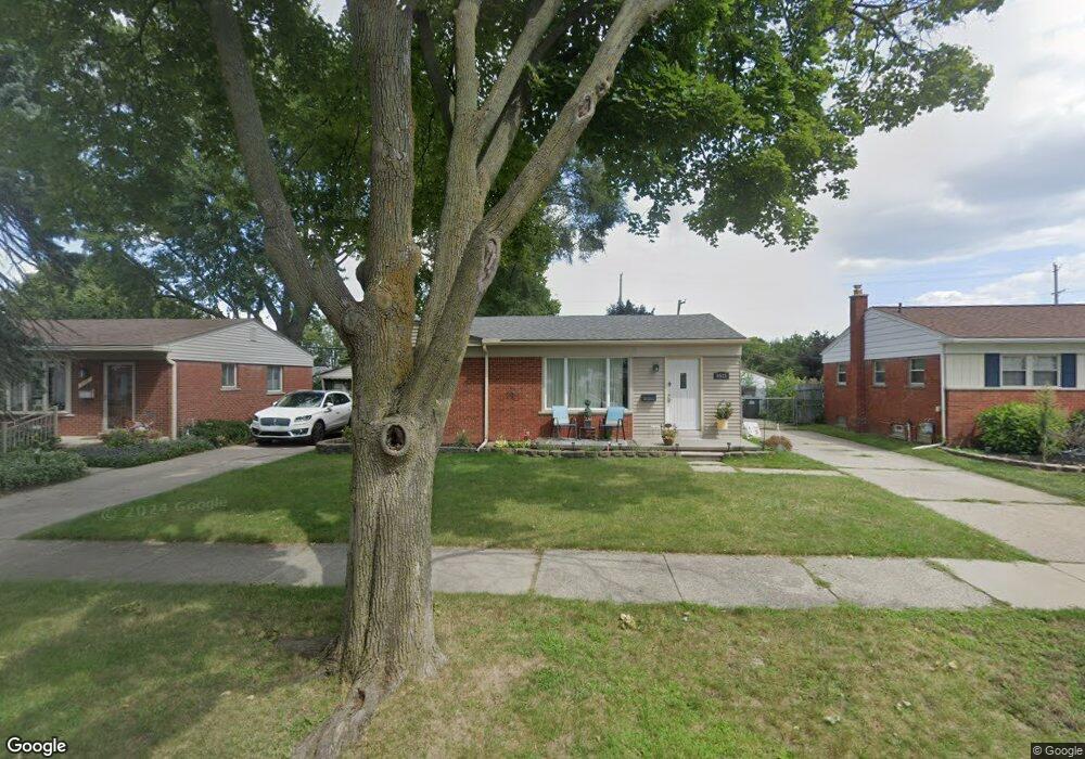
9533 Sylvester St Taylor, MI 48180
Estimated Value: $166,733 - $201,000
--
Bed
--
Bath
1,022
Sq Ft
$179/Sq Ft
Est. Value
About This Home
This home is located at 9533 Sylvester St, Taylor, MI 48180 and is currently estimated at $183,183, approximately $179 per square foot. 9533 Sylvester St is a home located in Wayne County with nearby schools including Kinyon Elementary School, Robert J. West Middle School, and Taylor High School.
Ownership History
Date
Name
Owned For
Owner Type
Purchase Details
Closed on
May 6, 2025
Sold by
Lafond Trevor and Lafond Dominique
Bought by
Lafond Management Llc
Current Estimated Value
Purchase Details
Closed on
May 17, 2019
Sold by
Federal Home Loan Mortgage Corporation
Bought by
Lafond Trevor Anthony
Purchase Details
Closed on
Jun 7, 2018
Sold by
Stewart Marilyn
Bought by
Lafond Trevor and Lafond Dominique
Purchase Details
Closed on
Mar 30, 2012
Sold by
Ritchie Michelle and Marker Gerald
Bought by
Stewart Marilyn
Purchase Details
Closed on
Mar 10, 2003
Sold by
Marker John C and Marker Shirley Marie
Bought by
Marker John C
Create a Home Valuation Report for This Property
The Home Valuation Report is an in-depth analysis detailing your home's value as well as a comparison with similar homes in the area
Home Values in the Area
Average Home Value in this Area
Purchase History
| Date | Buyer | Sale Price | Title Company |
|---|---|---|---|
| Lafond Management Llc | -- | None Listed On Document | |
| Lafond Management Llc | -- | None Listed On Document | |
| Lafond Trevor Anthony | $60,899 | None Available | |
| Lafond Trevor | -- | None Available | |
| Lafond Trevor | -- | None Available | |
| Stewart Marilyn | $60,000 | Reputation First Title Agenc | |
| Marker John C | -- | -- |
Source: Public Records
Tax History Compared to Growth
Tax History
| Year | Tax Paid | Tax Assessment Tax Assessment Total Assessment is a certain percentage of the fair market value that is determined by local assessors to be the total taxable value of land and additions on the property. | Land | Improvement |
|---|---|---|---|---|
| 2025 | $2,676 | $94,200 | $0 | $0 |
| 2024 | $2,676 | $87,800 | $0 | $0 |
| 2023 | $2,260 | $77,400 | $0 | $0 |
| 2022 | $1,807 | $68,200 | $0 | $0 |
| 2021 | $1,988 | $61,200 | $0 | $0 |
| 2020 | $1,968 | $54,100 | $0 | $0 |
| 2019 | $196,771 | $44,500 | $0 | $0 |
| 2018 | $2,210 | $38,300 | $0 | $0 |
| 2017 | $840 | $36,000 | $0 | $0 |
| 2016 | $2,556 | $34,900 | $0 | $0 |
| 2015 | $3,505 | $35,700 | $0 | $0 |
| 2013 | $3,490 | $35,600 | $0 | $0 |
| 2012 | $1,526 | $35,200 | $11,200 | $24,000 |
Source: Public Records
Map
Nearby Homes
- 9560 Sylvester St
- 22455 Meadow Woods Cir
- 9381 Pardee Rd
- 22150 Haig St
- 9942 Lincoln St
- 22327 Wick Rd
- 23364 Baker St
- 22311 Wick Rd
- 22333 Kinyon St
- 22129 Kinyon St Unit 52
- 9167 Groschner St
- 9883 Roosevelt St
- 23395 Pinewood Dr Unit 121
- 22134 Wick Rd
- 22382 Mary St
- 23210 Mary St
- 9062 Monroe Blvd
- 9788 Pine St
- 9602 Cornell St
- 9702 Cornell St
- 9549 Sylvester St
- 9521 Sylvester St
- 9563 Sylvester St
- 9507 Sylvester St
- 9534 Pardee Rd
- 9546 Pardee Rd
- 9522 Pardee Rd
- 9558 Pardee Rd
- 9577 Sylvester St
- 9510 Pardee Rd
- 9546 Sylvester St
- 9532 Sylvester St
- 9518 Sylvester St
- 9570 Pardee Rd
- 9591 Sylvester St
- 9574 Sylvester St
- 9504 Sylvester St
- 9608 Pardee Rd
- 9460 Pardee Rd
- 9469 Sylvester St