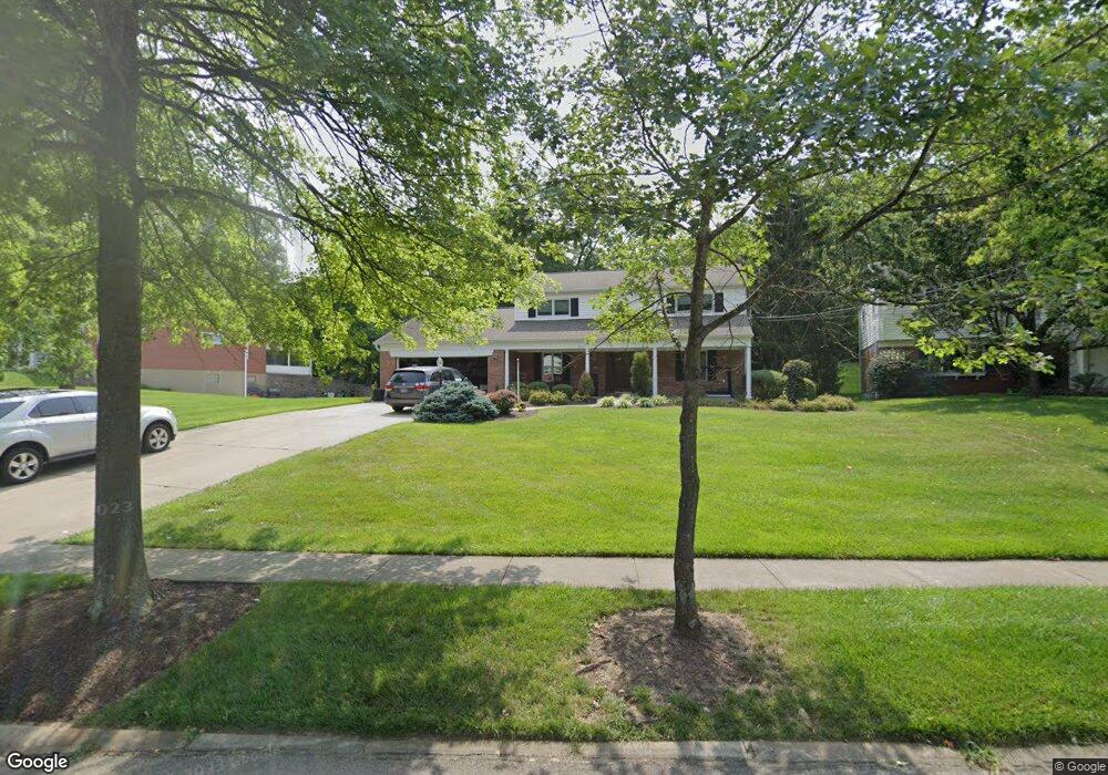
9545 Leebrook Dr Cincinnati, OH 45231
Winton Lake NeighborhoodEstimated Value: $314,000 - $345,000
4
Beds
4
Baths
2,238
Sq Ft
$148/Sq Ft
Est. Value
About This Home
This home is located at 9545 Leebrook Dr, Cincinnati, OH 45231 and is currently estimated at $331,209, approximately $147 per square foot. 9545 Leebrook Dr is a home located in Hamilton County with nearby schools including John Paul II Catholic School.
Ownership History
Date
Name
Owned For
Owner Type
Purchase Details
Closed on
Jul 11, 2008
Sold by
Sander William H and Sander Judith M
Bought by
Sander William H and Sander Beth R
Current Estimated Value
Home Financials for this Owner
Home Financials are based on the most recent Mortgage that was taken out on this home.
Original Mortgage
$160,000
Interest Rate
5.87%
Mortgage Type
Unknown
Create a Home Valuation Report for This Property
The Home Valuation Report is an in-depth analysis detailing your home's value as well as a comparison with similar homes in the area
Home Values in the Area
Average Home Value in this Area
Purchase History
| Date | Buyer | Sale Price | Title Company |
|---|---|---|---|
| Sander William H | $200,000 | Fidelity Land Title Agency O |
Source: Public Records
Mortgage History
| Date | Status | Borrower | Loan Amount |
|---|---|---|---|
| Closed | Sander William H | $160,000 |
Source: Public Records
Tax History
| Year | Tax Paid | Tax Assessment Tax Assessment Total Assessment is a certain percentage of the fair market value that is determined by local assessors to be the total taxable value of land and additions on the property. | Land | Improvement |
|---|---|---|---|---|
| 2025 | $6,184 | $90,664 | $16,044 | $74,620 |
| 2023 | $5,790 | $90,664 | $16,044 | $74,620 |
| 2022 | $6,105 | $71,709 | $15,145 | $56,564 |
| 2021 | $5,964 | $71,709 | $15,145 | $56,564 |
| 2020 | $6,049 | $71,709 | $15,145 | $56,564 |
| 2019 | $5,566 | $60,771 | $12,835 | $47,936 |
| 2018 | $5,578 | $60,771 | $12,835 | $47,936 |
| 2017 | $5,286 | $60,771 | $12,835 | $47,936 |
| 2016 | $5,218 | $58,814 | $12,964 | $45,850 |
| 2015 | $4,866 | $58,814 | $12,964 | $45,850 |
| 2014 | $4,849 | $58,814 | $12,964 | $45,850 |
| 2013 | $4,650 | $58,230 | $12,835 | $45,395 |
Source: Public Records
Map
Nearby Homes
- 650 Allencrest Ct
- 9458 Leebrook Dr
- 9469 Beech Dr
- 860 Sarbrook Dr
- 9315 Winton Rd
- 9319 Winton Rd
- 9441 Wyoming Point Place
- 9732 Woodmill Ln
- 9876 Lorelei Dr
- 9197 Long Ln
- 722 Compton Rd
- 9305 Bridgecreek Dr Unit 14A
- 946 Mckelvey Rd
- 9382 Stoneybrooke
- 429 Mccreary Ct
- 745 Compton Rd
- 9367 Stoneybrooke Unit 10G
- 357 Meadowcrest Rd
- 513 Chisholm Trail
- 343 Ashley Ln
- 9551 Leebrook Dr
- 9529 Leebrook Dr
- 9517 Leebrook Dr
- 9559 Leebrook Dr
- 9542 Galecrest Dr
- 9530 Galecrest Dr
- 9548 Leebrook Dr
- 9556 Leebrook Dr
- 9540 Leebrook Dr
- 9554 Galecrest Dr
- 9505 Leebrook Dr
- 9518 Galecrest Dr
- 9563 Leebrook Dr
- 688 Allencrest Ct
- 9564 Leebrook Dr
- 9566 Galecrest Dr
- 687 Allencrest Ct
- 9506 Galecrest Dr
- 9571 Leebrook Dr
- 9493 Leebrook Dr
Your Personal Tour Guide
Ask me questions while you tour the home.