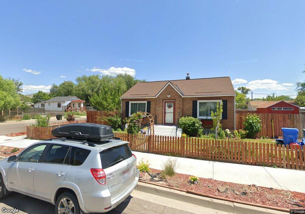
955 E Sherman St Pocatello, ID 83201
Downtown Pocatello NeighborhoodEstimated Value: $236,710 - $237,000
3
Beds
2
Baths
1,518
Sq Ft
$156/Sq Ft
Est. Value
About This Home
This home is located at 955 E Sherman St, Pocatello, ID 83201 and is currently estimated at $236,855, approximately $156 per square foot. 955 E Sherman St is a home located in Bannock County with nearby schools including Greenacres Elementary School, Irving Middle School, and Century High School.
Ownership History
Date
Name
Owned For
Owner Type
Purchase Details
Closed on
Sep 18, 2020
Sold by
Hinricks Deborah Marcks
Bought by
Hinricks Deborah Marcks
Current Estimated Value
Home Financials for this Owner
Home Financials are based on the most recent Mortgage that was taken out on this home.
Original Mortgage
$75,600
Outstanding Balance
$53,561
Interest Rate
2.9%
Mortgage Type
New Conventional
Estimated Equity
$183,294
Purchase Details
Closed on
May 23, 2007
Sold by
Hupe Kitty L
Bought by
Hinricks Deborah Marcks
Home Financials for this Owner
Home Financials are based on the most recent Mortgage that was taken out on this home.
Original Mortgage
$106,655
Interest Rate
6.18%
Mortgage Type
New Conventional
Create a Home Valuation Report for This Property
The Home Valuation Report is an in-depth analysis detailing your home's value as well as a comparison with similar homes in the area
Home Values in the Area
Average Home Value in this Area
Purchase History
| Date | Buyer | Sale Price | Title Company |
|---|---|---|---|
| Hinricks Deborah Marcks | -- | Accommodation | |
| Hinricks Deborah Marcks | -- | -- |
Source: Public Records
Mortgage History
| Date | Status | Borrower | Loan Amount |
|---|---|---|---|
| Open | Hinricks Deborah Marcks | $75,600 | |
| Closed | Hinricks Deborah Marcks | $106,655 |
Source: Public Records
Tax History
| Year | Tax Paid | Tax Assessment Tax Assessment Total Assessment is a certain percentage of the fair market value that is determined by local assessors to be the total taxable value of land and additions on the property. | Land | Improvement |
|---|---|---|---|---|
| 2025 | $923 | $170,971 | $60,000 | $110,971 |
| 2024 | $937 | $152,095 | $60,000 | $92,095 |
| 2023 | $1,064 | $156,844 | $60,000 | $96,844 |
| 2022 | $1,064 | $119,983 | $46,250 | $73,733 |
| 2021 | $1,045 | $119,983 | $46,250 | $73,733 |
| 2020 | $1,143 | $142,190 | $14,700 | $127,490 |
| 2019 | $1,215 | $123,031 | $11,760 | $111,271 |
| 2018 | $1,106 | $97,431 | $10,500 | $86,931 |
| 2017 | $1,098 | $97,431 | $10,500 | $86,931 |
| 2016 | $1,089 | $97,431 | $10,500 | $86,931 |
| 2015 | $1,100 | $0 | $0 | $0 |
| 2012 | -- | $102,659 | $10,500 | $92,159 |
Source: Public Records
Map
Nearby Homes
- 946 N 9th Ave
- 955 N 10th Ave
- 1028 N 9th Ave
- 908 E Hayden St
- 129 Wayne Ave
- 557 N 9th Ave
- 166 Washington Ave
- 168 Park Ave
- 1115 E Wyeth St
- TBD E Elm St
- Lot 19 Block 2 E Elm St
- 238 Randolph Ave
- 338 N 9th Ave
- LOT N 5th Ave
- 1221 E Fremont St
- 308 N 9th Ave
- 1046 E Lander St
- Lot 14 Block 2 E Lander St
- Lot 8 Block 1 E Lander St
- Lot 5 Block 1 E Lander St
Your Personal Tour Guide
Ask me questions while you tour the home.