Estimated Value: $160,318 - $227,000
Studio
1
Bath
1,600
Sq Ft
$126/Sq Ft
Est. Value
About This Home
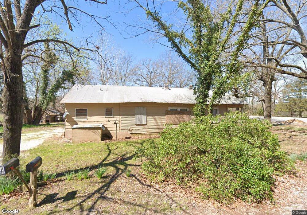
This home is located at 9555 Cord Rd, Cord, AR 72524 and is currently estimated at $201,439, approximately $125 per square foot. 9555 Cord Rd is a home located in Independence County with nearby schools including Cord-Charlotte Elementary School and Cedar Ridge High School.
Ownership History
Date
Name
Owned For
Owner Type
Purchase Details
Closed on
Feb 9, 2024
Sold by
Jericho Ag Llc
Bought by
The Rogers Group Llc
Current Estimated Value
Purchase Details
Closed on
Sep 27, 2023
Sold by
Randy L Bradley Irrevocable Family Trust
Bought by
Randy Bradley Irrevocable Trust and Bradley
Purchase Details
Closed on
Apr 22, 2000
Bought by
Mofield Charles William and Harrison Mofield %
Purchase Details
Closed on
Apr 21, 2000
Bought by
Mofield Harrison
Purchase Details
Closed on
Jul 23, 1986
Bought by
Roberts Ray
Purchase Details
Closed on
Nov 2, 1983
Bought by
Peck John C
Purchase Details
Closed on
Sep 26, 1982
Bought by
Perkins Charles J
Create a Home Valuation Report for This Property
The Home Valuation Report is an in-depth analysis detailing your home's value as well as a comparison with similar homes in the area
Purchase History
| Date | Buyer | Sale Price | Title Company |
|---|---|---|---|
| The Rogers Group Llc | $1,809,203 | None Listed On Document | |
| The Rogers Group Llc | $1,809,203 | None Listed On Document | |
| Randy Bradley Irrevocable Trust | -- | None Listed On Document | |
| Randy Bradley Irrevocable Trust | -- | None Listed On Document | |
| Randy Bradley Irrevocable Trust | -- | None Listed On Document | |
| Randy Bradley Irrevocable Trust | -- | None Listed On Document | |
| Mofield Charles William | -- | -- | |
| Mofield Harrison | $9,000 | -- | |
| Roberts Ray | $35,000 | -- | |
| Peck John C | -- | -- | |
| Perkins Charles J | -- | -- |
Source: Public Records
Tax History
| Year | Tax Paid | Tax Assessment Tax Assessment Total Assessment is a certain percentage of the fair market value that is determined by local assessors to be the total taxable value of land and additions on the property. | Land | Improvement |
|---|---|---|---|---|
| 2025 | $903 | $19,290 | $1,050 | $18,240 |
| 2024 | $903 | $19,290 | $1,050 | $18,240 |
| 2023 | $903 | $19,290 | $1,050 | $18,240 |
| 2022 | $903 | $19,290 | $1,050 | $18,240 |
| 2021 | $903 | $22,340 | $1,050 | $21,290 |
| 2020 | $1,046 | $22,340 | $1,050 | $21,290 |
| 2019 | $1,044 | $22,290 | $1,040 | $21,250 |
| 2018 | $1,044 | $22,290 | $1,040 | $21,250 |
| 2017 | $1,043 | $22,290 | $1,040 | $21,250 |
| 2016 | $1,044 | $22,290 | $1,040 | $21,250 |
| 2015 | $1,043 | $22,290 | $1,040 | $21,250 |
| 2014 | $1,061 | $22,670 | $1,010 | $21,660 |
Source: Public Records
Map
Nearby Homes
- 5 Summerset Ln
- Summerset Ln
- 0 Summerset Ln
- 155 Turkey Hill Rd
- 1962 Upper Lockhart Rd
- 1962 acres Upper Lockhart Rd
- 130 Blueberry Rd
- 787 Lower Lockhart Rd
- 183 Lawrence Road 352
- 310 Lawrence Road 333 Unit Option A
- 310 Lawrence Road 333 Unit Option B
- 3855 Antioch Rd
- 0 Lawrence Road 348
- 2132 Ar Hwy 230
- 2132 Arkansas 230
- 5976 Cord Rd
- 12 Shady Ln
- 65 Four Oaks Ln
- 70 and 76 Crow Ln
- 000 Milligan Campground Rd
Your Personal Tour Guide
Ask me questions while you tour the home.